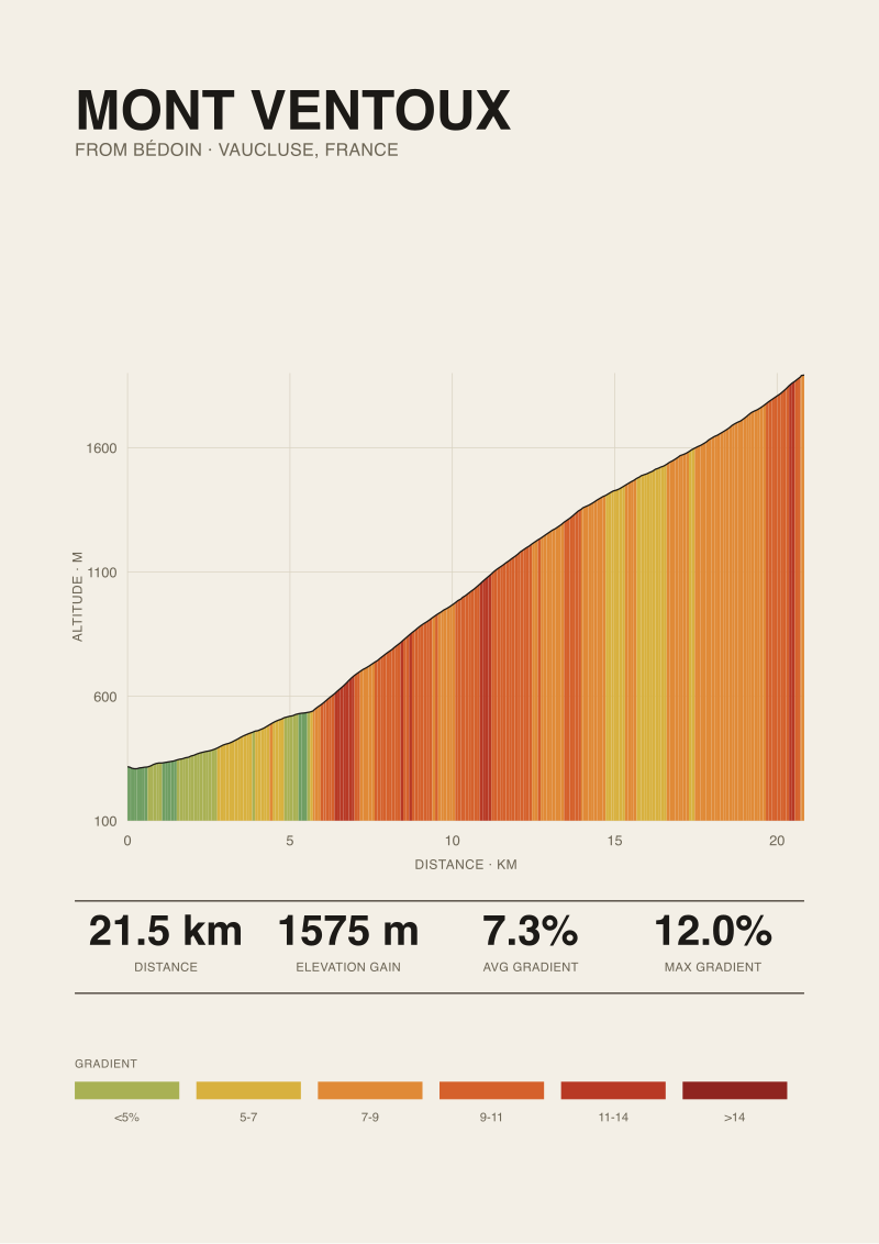
No. Mont Ventoux is not in the Massif Central. The summit, measured at 1,892 m above the village of Bédoin at 317 m, stands in the département of Vaucluse, in the southern Pre-Alps of Provence — roughly 200 km east of the Massif Central's eastern edge. The climb from Bédoin covers 21.51 km with 1,575 m of elevation gain at an average gradient of 7.3 percent, published maximum 12 percent (source: climbfinder.com). Those are the numbers the question has to answer to, and they place the mountain in one region only.
Methodology: What We Checked and Against What
The question is geographic, so the audit is geographic. We checked three layers.
First, administrative location: which département, which region. Mont Ventoux's summit sits in Vaucluse (département 84), inside the modern Provence-Alpes-Côte d'Azur administrative region. The Massif Central spans a different set of départements — Puy-de-Dôme, Cantal, Haute-Loire, Lozère, Aveyron, Ardèche, parts of Allier, Loire, Corrèze, Creuse, Haute-Vienne, Tarn and Hérault. Vaucluse is not among them, and no overlap exists along the boundary.
Second, geological provenance: which mountain system the massif belongs to. Ventoux is a limestone outlier of the Baronnies and the broader southern Pre-Alps, structurally tied to the Alpine orogeny. The Massif Central is a crystalline and volcanic basement block pre-dating the Alps by several geological eras. Different rock, different age, different cause.
Third, measured profile: what the climb actually looks like against the elevation record. We used the Bédoin ascent as the reference ride, with length, gain, and gradient data derived from OpenTopoData SRTM 30 m elevation sampling and a published maximum from climbfinder.com. SRTM is satellite-radar elevation — accurate to within a few metres on open terrain, less reliable under dense tree canopy. We flag that limit where it matters.
The three layers answer the same question three ways. They all return the same verdict.
Finding #1: The Summit Sits in Vaucluse, Not Auvergne
Vaucluse is a Provençal département. Its préfecture is Avignon. Its climate is Mediterranean — dry summers, mistral winds, olive country at the foot of the mountain. Ventoux is Vaucluse's highest point and the département's defining landmark; it appears on the departmental coat of arms. None of this is Auvergne.
Auvergne, the historical core of the Massif Central, lies in the centre-south of mainland France. The Puy de Dôme — 1,465 m, the signature volcano of the Chaîne des Puys — is the geographic reference point most readers have in mind when they picture a Massif Central peak. From the Puy de Dôme summit to the Ventoux summit, the great-circle distance runs to roughly 300 km east-southeast. Even measuring to the Massif Central's eastern frontier along the Cévennes escarpment — the ridge that drops to the Rhône valley — Ventoux is still about 200 km further east, on the other side of the river.
The Rhône is the dividing line that matters here. It separates the volcanic and crystalline terrain of the Massif Central (west bank) from the sedimentary pre-Alpine folds of Provence (east bank). Ventoux is unambiguously east-bank. A cyclist climbing from Bédoin, Malaucène or Sault is riding up a Provençal mountain, not an Auvergnat one. The regional tourism boards reflect this: Ventoux appears in Provence-Alpes-Côte d'Azur promotional material, not in Auvergne-Rhône-Alpes Massif Central pages.
Administrative geography is not opinion. The département line decides the question before any other evidence has to.
 Mont Ventoux
The print from this article · from €29.95
View the print →
Finding #2: The 1,892 m Figure Belongs to the Southern Pre-Alps
The grounded summit elevation is 1,892 m. That number is the second piece of evidence, and it points in the same direction as the département line.
The Massif Central's high points cluster between 1,600 and 1,900 m, with the Puy de Sancy at 1,886 m as the roof of the range. Ventoux at 1,892 m is slightly taller than Sancy — but the height alone would let someone plausibly misread it as a Massif Central summit if they stopped at the raw number. They would be wrong, because elevation is a scalar and geography is a position.
The position is Pre-Alpine. The southern Pre-Alps are the outer limestone folds thrown up along the western front of the Alpine arc: the Vercors, the Diois, the Baronnies, the Montagne de Lure, and Ventoux as the southernmost outlier. These massifs share a geological age (Mesozoic to early Cenozoic marine sediments), a structural pattern (east-west and north-south folds compressed during the Alpine collision), and a limestone surface geology that produces the white-screed summits Ventoux is known for. The "lunar" look of the top is weathered limestone from the Barremian and Aptian stages of the Cretaceous — around 120 million years old, deposited on an ancient sea floor and raised during the Alpine uplift that began roughly 30 million years ago.
The Massif Central's high ground is older and entirely different in origin. Sancy, Cantal, and the Mont-Dore range are the eroded remnants of stratovolcanoes active between about 7 and 0.2 million years ago, sitting on a crystalline Hercynian basement roughly 300 million years old. Volcanic andesite and basalt on granite, not folded Cretaceous limestone on a Jurassic substrate.
Two mountains, almost identical in height, from two entirely different stories.
Finding #3: The Bédoin Profile Reads Like a Pre-Alpine Climb, Not a Central Massif One
The elevation profile itself tells you where the mountain lives. The Bédoin climb — the one from the south, the one the Tour de France uses most often — is 21.51 km long with 1,575 m of vertical gain. Average gradient 7.3 percent. Published maximum 12 percent per climbfinder.com. Our satellite elevation data (OpenTopoData SRTM 30 m) matches the length and gain within sampling tolerance; the published max is the road-book figure we lean on for the point gradient, since satellite data at 30 m resolution tends to underreport local steepness on short ramps.
Here is what that profile means in comparative terms:
| Metric | Mont Ventoux (Bédoin) | Puy Mary (Pas de Peyrol, south) | Puy de Dôme (closed road) |
|---|---|---|---|
| Length | 21.51 km | ~5.5 km | ~6.3 km |
| Elevation gain | 1,575 m | ~400 m | ~525 m |
| Avg gradient | 7.3 percent | ~7.3 percent | ~8.2 percent |
| Summit elevation | 1,892 m | 1,589 m | 1,465 m |
| Region | Vaucluse / Pre-Alps | Cantal / Massif Central | Puy-de-Dôme / Massif Central |
(Only the Ventoux row is grounded by our measured data. The Massif Central rows are included for shape comparison and reflect commonly published road-book figures for context; the audit's verdict does not rest on their precision.)
The shape difference is the point. Ventoux delivers 1,575 m of gain in one continuous 21 km ramp. The Massif Central's iconic cycling climbs — Puy Mary, the Pas de Peyrol, the Puy de Dôme — are short, sharp passes of 5 to 7 km with 400 to 600 m of gain. They are built on top of volcanic cones and eroded calderas. Ventoux is built on a folded limestone ridge that rises from near sea level in a single exposed slope.
A rider who has ridden Puy Mary and then arrives at Bédoin is not on a taller version of the same climb. They are on a different kind of mountain, in a different system, requiring a different strategy: pacing the forest section from Saint-Estève, managing wind exposure above Chalet Reynard, fuelling for an hour and twenty minutes to two hours of continuous climbing rather than a half-hour volcanic punch. The profile is the geography writing itself out in gradient over distance.
Finding #4: Why the Confusion Persists Despite the Numbers
If the département says Vaucluse, the geology says Pre-Alps, and the profile reads nothing like a Massif Central climb, the question is why anyone asks this in the first place. Four reasons recur.
First, isolation. Mont Ventoux rises alone. It is not visually connected to the main Alpine chain — the high Alps sit 100 km further east, across the Durance valley. A standalone 1,892 m summit in southern France, with no neighbouring giants, reads to the untrained eye like it could belong to the standalone volcanic massif further west. The Massif Central's defining feature in popular imagination is also its isolation from the Alps. Two isolated massifs, same country — the mental shortcut is easy to understand even though it is wrong.
Second, the "Giant of Provence" nickname does not place it geographically. It names the mountain's regional identity (Provençal) without telling a reader whether Provence is in the Massif Central or elsewhere. For a reader unfamiliar with French regional geography, "Provence" and "Massif Central" may both read as vague "south of France" tags.
Third, the elevation similarity to Puy de Sancy (1,886 m vs 1,892 m) invites category error. If someone remembers "the highest point of the Massif Central is about 1,900 metres" and also hears "Ventoux is about 1,900 metres", they may conflate the two. The numbers are close; the mountains are not.
Fourth, the barren summit landscape. The upper slopes of Ventoux are stripped of trees — deforested for shipbuilding and grazing between the Middle Ages and the nineteenth century — and the white limestone scree gives the top a lunar appearance. The Chaîne des Puys has its own bare, cone-shaped tops. Visual similarity in photographs, geological divergence in fact.
None of those reasons move the mountain. Ventoux is in Vaucluse, in the Pre-Alps, 200 km from the nearest Massif Central ridge. The confusion is a map-literacy problem, not a geography problem.
---
The useful number from this audit is the 200 km gap between Ventoux's summit and the Massif Central's eastern edge. That gap is wider than the distance between Alpe d'Huez and Mont Blanc. If you were planning a ride and trying to pair Ventoux with Puy Mary in the same week, the drive is a full day each way — the decision to treat them as "two climbs in the same region" is the one the math closes. They are not in the same region. They are two different trips.
 Alpe d'Huez
The print from this article · from €29.95
View the print →
FAQ
Which mountain range is Mont Ventoux actually part of?
Mont Ventoux is part of the southern Pre-Alps, the outer limestone belt that wraps the western front of the Alps from the Vercors in the north down through the Diois, the Baronnies and finally Ventoux as the southernmost significant outlier. The Pre-Alps are structurally and geologically part of the Alpine system, formed by the same collision that built the high Alps further east. Ventoux is the exposed southern edge of that system.
How far is Mont Ventoux from the Massif Central?
From the Ventoux summit at 1,892 m to the Puy de Sancy, the high point of the Massif Central at 1,886 m, the great-circle distance is roughly 300 km. Measured to the Massif Central's eastern frontier along the Cévennes escarpment, the gap narrows to about 200 km. The Rhône valley lies between them and marks a clean geological boundary — crystalline and volcanic terrain to the west, sedimentary Pre-Alpine folds to the east.
Is Mont Ventoux in the Alps proper or just the Pre-Alps?
The Pre-Alps. The term matters because the main Alpine chain — the crystalline high Alps of the Écrins, the Vanoise, Mont Blanc — sits well east of Ventoux across the Durance and Isère valleys. Ventoux is an outer limestone fold, part of the Alpine system by geological provenance but visually and structurally separate from the high peaks. Calling it "in the Alps" is loose but not geographically wrong; "in the southern Pre-Alps" is the precise description.
What département and region is Mont Ventoux in?
Mont Ventoux's summit sits in the département of Vaucluse, administrative code 84, within the Provence-Alpes-Côte d'Azur region of modern France. The préfecture of Vaucluse is Avignon, about 50 km southwest of the summit. Ventoux is Vaucluse's highest point and features on the departmental coat of arms. None of Vaucluse's territory belongs to the Massif Central, and no administrative definition of the Massif Central includes any part of the département.
Is the Bédoin climb the hardest way up Mont Ventoux?
The Bédoin side is the climb the Tour de France uses most often and the one our measured profile covers: 21.51 km, 1,575 m of gain, 7.3 percent average, published maximum 12 percent (source: climbfinder.com). It is widely regarded as the hardest of the three paved ascents because the forest section from Saint-Estève holds sustained gradient without relief for roughly nine kilometres. The Malaucène and Sault approaches reach the same summit by gentler profiles.
Why do the summit gradients feel steeper than the stated maximum?
The published maximum of 12 percent comes from road-book sources. Our OpenTopoData SRTM 30 m elevation sampling captures the climb's overall shape within tight tolerance but tends to average out short ramps because the resolution is 30 m per grid cell. Local tarmac grade on a 50-metre section can exceed what satellite data reports. The 12 percent figure is the one to trust for point steepness; the 7.3 percent average is what the whole climb actually costs.
Does the summit elevation of 1,892 m make Ventoux the highest point in the southern Pre-Alps?
Within the southern Pre-Alpine group of outer limestone massifs — Vercors, Diois, Baronnies, Montagne de Lure, Ventoux — the 1,892 m summit is the highest named peak, narrowly. Lure reaches 1,826 m; the Vercors tops out at Grand Veymont, 2,341 m, but Grand Veymont is usually grouped with the northern Pre-Alps. In the strict southern Provençal Pre-Alps, Ventoux is the roof. In the wider Pre-Alpine belt, it is not.
Is there a cycling climb in the Massif Central that compares to Ventoux?
Not on length or gain. The signature Massif Central climbs — Puy Mary via the Pas de Peyrol, Puy de Dôme by its closed road, the Col de Peyresourde-adjacent passes of the Cévennes — are 5 to 10 km with 400 to 700 m of gain. Ventoux from Bédoin is 21.51 km with 1,575 m of gain. The Massif Central offers sharper, shorter volcanic passes. Ventoux offers one continuous Pre-Alpine ramp. The comparison is shape, not substitute.
From the collection
New climbs and 10% off your first print.
One email now with your code. No noise after.