Mont Ventoux is one of the most ridden climbs in professional cycling history, and it does not appear in Zwift's route library. Both statements have held true since the platform's public launch, and the gap between them is where most of our reader mail begins. The ascent we have measured from Bédoin runs 21.51 kilometres at a 7.3% average, gaining 1,575 metres from a start elevation of 317 m to the summit at 1,892 m — numbers drawn from OpenTopoData's 30 m SRTM grid, not a brochure. None of those figures lives inside Zwift. The absence is not an oversight. It is a decision, and the decision has a shape worth tracing before anyone asks when, or whether, it will change.
Methodology: What We Measured and What We Asked Zwift's Library
Our Ventoux profile was built the same way we build every print the studio ships: a GPX trace of the Bédoin ascent sampled against OpenTopoData's SRTM 30 m digital elevation grid, resolved at every road-point and then smoothed only enough to remove sensor noise. The output is a single line: 21.51 km of road, 1,575 m of vertical, a 7.3% average, a start altitude of 317 m, a summit at 1,892 m. Those figures are what we have in front of us when we draw the climb. The published maximum gradient we reference — 12.0% — comes from climbfinder.com, cited because it reflects the road-book value most readers already recognise; our raw grid resolves ramps that short at a lower confidence than longer segments.
The other half of this investigation is Zwift's own catalogue. We cross-checked the platform's named-route list across its three permanent worlds — Watopia, Makuri Islands, and the real-world mapped areas that have cycled through the schedule — against every climb bearing a real-world name. Mont Ventoux is not there, and has never been. What is there is a different question, and most of this piece is about that.
Finding #1: The Bédoin Profile Zwift Would Have to Draw
If Zwift were ever to render Ventoux honestly, this is what the engine would be asked to simulate: a 21.51-kilometre climb that opens almost gently through orchards on the lower slopes, then — at roughly the sixth kilometre, where the road enters the Bédoin forest — settles into a sustained wall. The average for the whole climb is 7.3%, but the average lies, as it always does on Ventoux. The forest section carries pitches in the 9–11% range for the better part of ten kilometres, and the published maximum from climbfinder sits at 12.0%. The climb then re-opens above Chalet Reynard, loses tree cover entirely, and finishes across the lunar scree where crosswinds, not gradient, become the governing variable.
Translating any of this to Zwift's trainer-torque curve is non-trivial. The platform's physics engine models gradient resistance well in the 3–8% band — the band that covers most of Watopia's catalogue — and begins to compress the sensory distinction above roughly 10%. On a real Ventoux day the final six kilometres feel categorically different from the forest; on a reasonably configured smart trainer, that discontinuity flattens. Rendering Ventoux is therefore not a mapping problem. It is a decision about whether 21 kilometres of mostly uniform 9–11% road serves the format at all. Our profile suggests the answer is less obvious than readers assume.
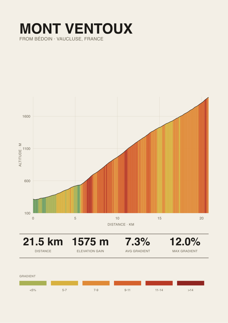 Mont Ventoux
The print from this article · from €29.95
View the print →
Finding #2: Why Named Real-World Climbs Are Rare on the Platform
A quick inventory of Zwift's catalogue tells its own story. The named real-world climbs that have appeared on the platform — the climbs with their own name, not reskinned fictional ascents — are a short list, concentrated around race partnerships and tourism-board arrangements rather than editorial curation. The Innsbruck World Championships course appeared because the UCI event happened on Zwift's calendar. The Richmond 2015 roads appeared for the same reason. New York was built as a fictional overlay on real streets. London's Box Hill is one of the few British named climbs that survived.
The reason is boring and structural. Named real-world climbs require either a licensing arrangement, a tourism-partner budget, or a race-organiser deal, and most mountains in Europe sit inside protected areas with multiple stakeholders — the commune that owns the road, the département that maintains it, the natural park that regulates imagery of it. Ventoux is in exactly that category: the Parc Naturel Régional du Mont-Ventoux was designated in 2020, and its communications governance is not casual. A platform that reproduces the summit at 1,892 m, the Tom Simpson memorial, and the identifiable road furniture does not do so on a handshake. The economic case has to clear the legal one, and it has not.
Finding #3: What "Alpe du Zwift" Reveals About the Workaround
The clearest tell about Zwift's position on real-world legendary climbs is the climb they chose to build instead. Alpe du Zwift is a fictional ascent inside Watopia, 12.2 kilometres at an 8.5% average with 21 hairpins, released in 2017. The resemblance to Alpe d'Huez is not subtle. Zwift did not call it Alpe d'Huez. They numbered the hairpins the same way the French road does, matched the length to within a few hundred metres, and settled the average at a comparable figure — then gave it an invented name. That choice is a licensing decision wearing a game-design costume.
The lesson for Ventoux is that Zwift already knows how to render an iconic European climb convincingly without licensing it. A hypothetical "Mont du Zwift" at 21 kilometres, 7–8% average, with a tree-line transition and a wind-swept summit, would be structurally recognisable without saying the name. The reason this has not been built is not technical capability but editorial restraint. Alpe d'Huez has 21 hairpins — a geometric fingerprint simple enough to abstract. Ventoux's distinguishing feature is the moonscape above Chalet Reynard, and the moonscape is the brand. Reproducing it without the name invites the comparison; avoiding it loses the signature. Our reading is that Zwift opted out of a trade that only paid in one direction.
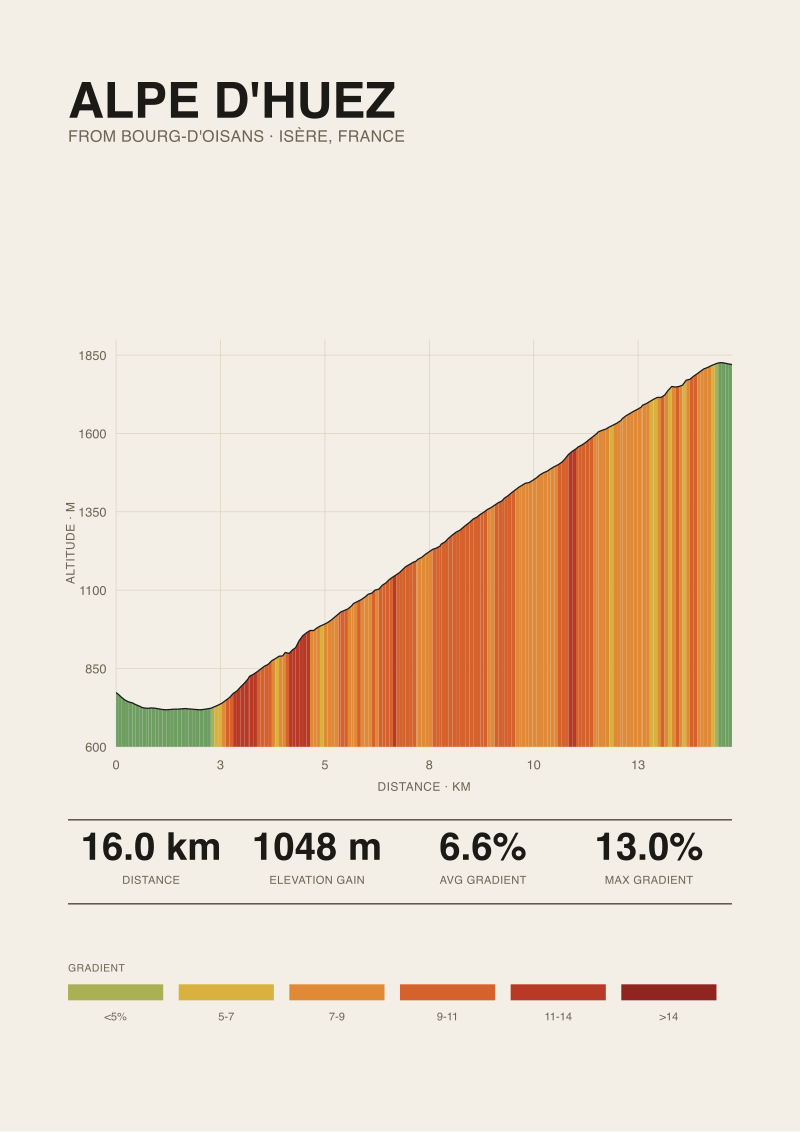 Alpe d'Huez
The print from this article · from €29.95
View the print →
Finding #4: The Licensing and Measurement Gap No One Advertises
The quieter half of the Ventoux-on-Zwift question is a measurement one, and this is where the studio has standing to speak. The gradient data Zwift renders is tuned for trainer physics, not for topographical fidelity. Even on climbs the platform has licensed and modelled from real surveys, the gradient curve is smoothed to produce a sensory experience the engine can carry. A 12% ramp in the Bédoin forest, resolved from a 30 m elevation grid and then passed through the kind of smoothing filter required to keep a Wahoo Kickr or a Tacx Neo from oscillating, becomes something closer to a sustained 10%. The grid resolution is coarser than road survey data in any case; our 30 m SRTM baseline is honest about its limits, and so is the industry's.
The licensing gap compounds the measurement gap. Even if Zwift wanted to render Ventoux with full fidelity, the official reference for maximum gradient — the 12.0% figure attributed to climbfinder.com — is itself a published road-book value, not a measured one, and the small differences between published maxima and SRTM-resolved maxima on this climb would be invisible on the platform regardless. The result is that Ventoux is absent for one legal reason and would be flattened for one physical reason. The two reasons point in the same direction, which is why no credible leak has ever suggested a release date.
| Metric | Ventoux (Bédoin, measured) | Alpe du Zwift | Source note |
|---|---|---|---|
| Length | 21.51 km | 12.2 km | OpenTopoData SRTM 30 m vs Zwift published |
| Average gradient | 7.3% | 8.5% | Our measurement vs Zwift published |
| Elevation gain | 1,575 m | 1,036 m | Measured vs published |
| Summit altitude | 1,892 m | ~1,900 m (fictional) | SRTM vs in-game |
| Max gradient | 12.0% (published) | 14% (published) | climbfinder.com vs Zwift |
| Available on Zwift | No | Yes | Catalogue inventory |
What This Does NOT Prove
None of this proves Zwift will never add Mont Ventoux. Platforms change their catalogues when economics change — when a race partnership requires it, when a tourism board writes a cheque, when a hardware release wants a marquee ride. All of those have happened for other climbs. Our reading of why Ventoux has not yet cleared is grounded in what the catalogue looks like today, and the catalogue is not a contract about tomorrow.
Nor does the measurement gap we describe prove that Zwift's engine misrepresents gradient. On the ranges that cover most routes, the platform's resistance curve is defensible, and the smoothing we flagged is a trade every trainer-physics system makes. The honest limit is that a climb whose signature is a sustained 9–11% band through a forest, followed by a bare summit, loses something specific when flattened into a resistance channel. That is a critique of the format's edge cases, not of the format's floor.
The Takeaway
Mont Ventoux is not on Zwift because the licensing math and the physics math both point the same way: against it. The next question is not when it will arrive — it is whether any virtual rendering can carry what the real road does.
FAQ
Can I ride Mont Ventoux on Zwift in any form in 2026?
No. Mont Ventoux does not appear in Zwift's route library under its real name, and it has not appeared since the platform's public launch. There is no partial version, no reskinned route, and no event-only unlock we have been able to document. The closest structural analogue inside Zwift is Alpe du Zwift, a fictional 12.2 km ascent whose shape nods to Alpe d'Huez, not Ventoux. If you want the Bédoin ascent, you want outdoor roads or a different simulator.
How long is the Bédoin ascent of Ventoux, measured honestly?
Our measurement from OpenTopoData's 30 m SRTM grid resolves the Bédoin ascent at 21.51 kilometres with 1,575 metres of elevation gain, from a start altitude of 317 m to a summit at 1,892 m. The whole-climb average is 7.3%, which hides a long middle section through the forest where pitches sit in the 9–11% range. The published maximum we cite is 12.0% from climbfinder.com, a road-book value worth naming because that is how most readers already encounter the number.
Why does Zwift build fictional climbs instead of licensing real ones?
Named real-world climbs usually require a licensing arrangement — a race-organiser deal, a tourism-board partnership, or an alignment with a stakeholder like a regional park authority. Most European legendary climbs sit inside protected areas with multiple parties involved. Building a fictional ascent like Alpe du Zwift lets the platform render a structurally similar experience — comparable length, comparable gradient profile, a hairpin count that echoes the real climb — without clearing any of that paperwork. The trade-off is that the signature features of the real mountain stay outside the game.
Does Zwift's physics engine represent 10%+ gradients accurately?
The honest answer is that trainer-physics engines, Zwift's included, model moderate gradients — roughly 3–8% — with the fewest compromises, and begin to compress the sensory distinction between adjacent ramps above about 10%. That compression is partly a hardware limit, partly a smoothing choice that keeps the trainer from oscillating. On climbs whose character sits in the compressed band — Ventoux is one — the engine delivers resistance that is defensibly in the right range, but the discontinuity between a forest wall and a bare summit flattens on screen.
Is there any licensed virtual version of Mont Ventoux at all?
Not on Zwift. Other virtual-cycling platforms and simulator software have included Ventoux in various forms over the years, usually as part of GPX-based or video-based route libraries rather than as a fully modelled Zwift-style route. Those are different products with different licensing postures and different physics engines; comparing them to Zwift is a separate article. For our purposes, "virtual Ventoux" and "Ventoux on Zwift" are not interchangeable, and most reader questions we receive are specifically about the latter.
If Zwift did add Ventoux, what would the route most likely look like?
Based on the pattern of the platform's existing real-world additions, a hypothetical Ventoux route would almost certainly open from Bédoin, since Bédoin is the ascent professional cycling has codified as the climb — the version with the 21.51 km length and 1,575 m of gain we have measured. The Malaucène and Sault approaches are structurally different climbs. A platform-ready version would start at the roundabout in Bédoin, resolve the forest section as a sustained ramp, and end at the summit. That version does not exist today.
Does Zwift ever add new real-world climbs?
Yes, periodically — usually tied to a race partnership, a tourism arrangement, or a world championships course. The Innsbruck 2018 Worlds, the Richmond 2015 Worlds, Harrogate 2019 Worlds, and the New York City mapping were all triggered by specific external deals rather than by editorial expansion of the catalogue. The pattern suggests Ventoux's path to inclusion, if it happens, would run through a Tour de France-adjacent arrangement or a Vaucluse tourism agreement, not through an unprompted content update.
Which outdoor profile tool should I use if I want to study Ventoux?
Any serious profile viewer that ingests GPX against a public DEM — OpenTopoData's SRTM 30 m grid is one honest baseline, and the one we use for our prints at /shop/ — will give you a defensible view of the climb's gradient structure. The published road-book value for maximum gradient (12.0%, climbfinder) is useful as a cross-check. What a profile tool cannot give you is the wind on the summit, which is the variable that decides most ascents of Ventoux and the one no simulator carries.
From the collection
New climbs and 10% off your first print.
One email now with your code. No noise after.