Most beautiful cycling climbs in the Dolomites" is a query that returns thousands of ranked lists, almost none of which measured the climbs before ranking them. Our profile library, drawn from OpenTopoData SRTM 30m elevation samples, currently holds 25.04 km of Passo dello Stelvio from Prato allo Stelvio and 18.42 km of Passo di Gavia from Ponte di Legno — both sitting at the western frontier of what riders casually call Dolomite country, neither geographically Dolomite. That distinction matters, because "beautiful" in a road-cycling context is not a mountain-range judgment. It is a profile-shape argument, and profile shape is what we can talk about honestly.
We are going to walk through three riders who could plausibly type that query into a search bar. Each one wants something different, though the words in the search box are identical. Only one of them is asking the question the geography actually answers, and even that rider is going to hit the limits of what our current library can tell them. What we can do is show where the data holds up, where it doesn't, and what a profile-first reader should take away in each case.
Scenario 1: The Rider Planning a First Alpine Trip Around Three Names
Picture a rider who has never been higher than 1,200 metres on a road bike, is booking a week in northern Italy for the first time, and has arrived at three names on a shortlist because those are the names that trip reports keep returning: Stelvio, Gavia, and something in the Sella group. The trip is real; the persona is a composite; the shortlist logic is what nearly every first-timer we speak to arrives with.
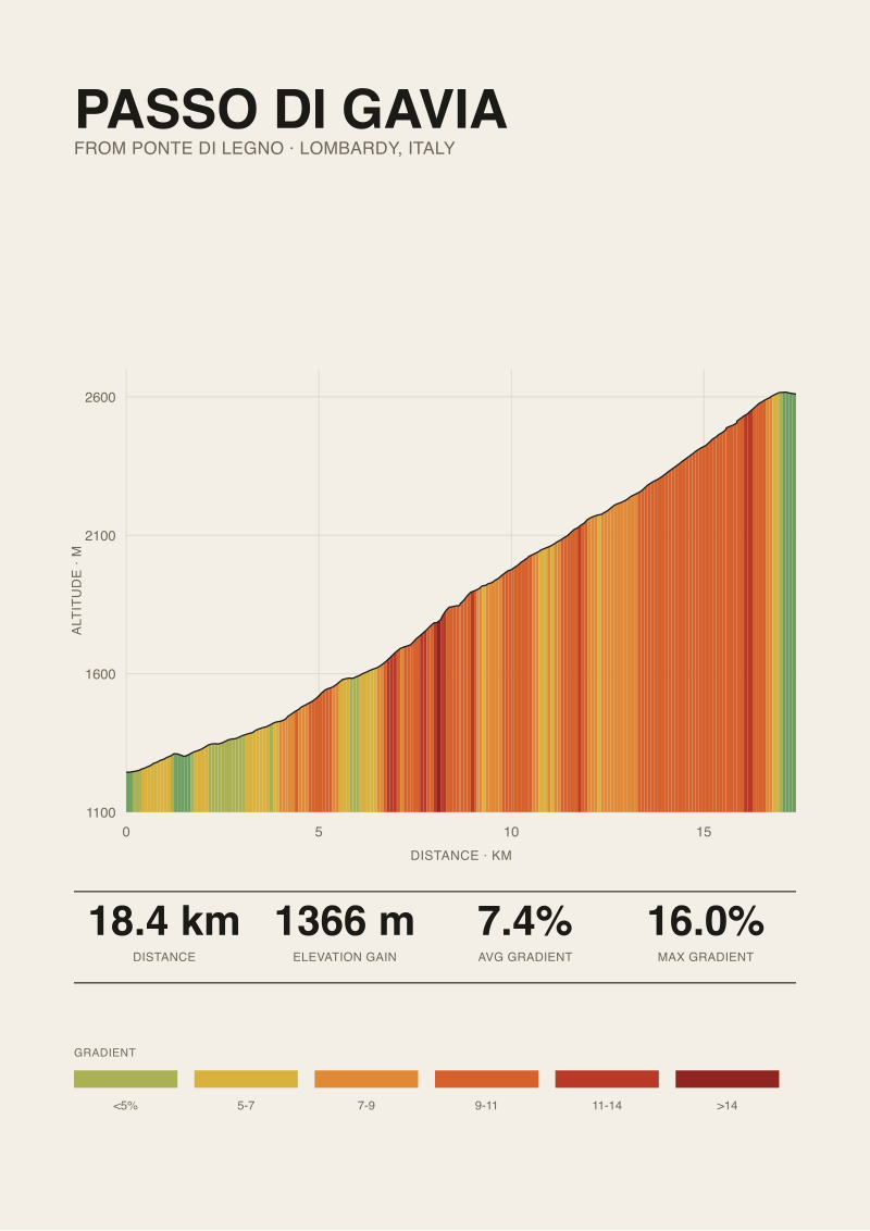
Here is what our data can tell that rider about two of those three names. Passo dello Stelvio from Prato allo Stelvio is 25.04 km long, gains 1,840 metres, and averages 7.3 percent. It starts at 908 metres and finishes at 2,748 metres. Passo di Gavia from Ponte di Legno is 18.42 km, 1,366 metres of gain, 7.4 percent average, finishing at 2,610 metres. Two climbs, two summits above 2,600 metres, roughly 25 km apart as the crow flies. A rider based in Bormio for four days can ride both without repositioning, which is not something we can say about the third name on the shortlist.
The third name — anything in the Sella group, Pordoi, Fedaia, Giau — is a two-and-a-half-hour transfer east from Bormio. Our library does not currently hold measured profiles for those climbs, so we are not going to tell this rider whether Pordoi from Arabba is more or less punishing than Gavia from Ponte di Legno. What we will say is that the practical answer for a first Alpine week is to accept that the western climbs and the true Dolomites are two separate trips, not one. Base yourself in Bormio, do Stelvio and Gavia as measured, and treat the Sella loop as next year.
The other honest observation, on the two climbs we do have: they are structurally similar. Both are just over 7 percent on average, both put you above 2,600 metres, both are long enough that pacing matters more than gearing choice. If a rider is trying to decide which one to attempt first, Gavia is 6.62 km shorter and 474 metres less climbing. Stelvio, from Prato allo Stelvio, is the longer sustained effort. That is the whole comparison. Whichever you climb first, the second one asks the same question with a different answer.
Scenario 2: The Rider Chasing the Steepest Ramp in the Library
Let us imagine a different rider. This one has done Ventoux from Bédoin twice, the Tourmalet from Luz-Saint-Sauveur once, and has arrived at the Dolomites query specifically hunting for a ramp — a section where the road tilts to double digits and stays there. The premise of the search is not scenery. It is the maximum figure on the profile.
The comparison our library can support is narrow but useful. Ventoux from Bédoin publishes a maximum gradient of 12.0 percent, sourced from climbfinder.com. Tourmalet from Luz publishes the same 12.0 percent, same source. Stelvio from Prato allo Stelvio publishes 14.0 percent. Gavia from Ponte di Legno publishes 16.0 percent. On the published road-book figures for the four climbs in our library, Gavia is the steepest at its worst point.
The caveat we have to name plainly: those maximum figures are published road-book values, not sustained gradients we measured continuously. Our own elevation samples come from OpenTopoData's SRTM 30m dataset, which is satellite-derived at thirty-metre horizontal resolution. That resolution is honest about the shape of a climb over hundreds of metres. It is not the right instrument for arguing about a fifty-metre ramp inside a hairpin. When a rider wants to know "how bad does it get for one specific bend," the published road-book figure — the one every guidebook has been copying from the same source since the 1990s — is what we can point to, not what we can independently confirm.
So if this rider wants the steepest ramp our four-climb library can promise, the honest answer is Gavia from Ponte di Legno at a published 16 percent maximum, and the honest asterisk is that we have not measured that ramp segment ourselves at a resolution fine enough to defend the number to a decimal place. If the query is really about the steepest climb in the wider Dolomite range — Zoncolan, Mortirolo — those profiles are not in our library yet, and we would rather say so than invent a comparison.
 Passo dello Stelvio
The print from this article · from €29.95
View the print →
Passo dello Stelvio
The print from this article · from €29.95
View the print →
Scenario 3: The Rider Who Wants the Highest Paved Summit in the Data
Now imagine a rider who has spent the last three seasons ticking off altitudes: the Galibier, the Iseran, an aborted attempt at the Bonette. What they are searching for, under the Dolomites keyword, is the highest paved summit they can ride to on a road bike in northern Italy without needing a mountain-bike gearing or a gravel setup.
This is the one scenario where our current library gives a clean answer. Passo dello Stelvio from Prato allo Stelvio ends at 2,748 metres, gaining 1,840 metres from a start at 908 metres. Passo di Gavia from Ponte di Legno ends at 2,610 metres, gaining 1,366 metres from a start at 1,244 metres. For comparison, Mont Ventoux from Bédoin finishes at 1,892 metres, and Col du Tourmalet from Luz finishes at 2,114 metres. Stelvio, in our library, is 634 metres higher than Tourmalet and 856 metres higher than Ventoux at the top.
For the altitude-hunting rider, that is the summary: Stelvio from Prato allo Stelvio is the highest paved summit currently in our profile data, and Gavia from Ponte di Legno is the second. Both of those numbers hold up whether or not we call the surrounding geology "Dolomite," because they are altitudes above sea level, not range assignments.
Two operational notes we can add without straying from the data. First: the difference between starting a climb at 908 metres, as Stelvio does from Prato, and starting at 1,244 metres, as Gavia does from Ponte di Legno, is 336 metres of thinner-air adaptation the Stelvio side does not give you. A rider used to sea-level rides will feel more of the altitude curve on Stelvio simply because they cover more of it. Second: the total gain figures — 1,840 metres for Stelvio, 1,366 metres for Gavia — are the honest comparison for how much work each climb represents. Summit altitude tells you what postcard you take at the top. Gain tells you what the day cost you.
What All Three Reveal About the Dolomites Search
The three composite riders are asking three different questions and arriving at the same search term. That mismatch is what our data actually diagnoses. The first-timer wants a manageable, defensible itinerary and is getting listicles that have never distinguished western passes from true Dolomite climbs. The ramp-hunter wants a maximum gradient and is getting adjectives. The altitude-hunter wants a summit elevation and is getting the same photo of the same hairpin, repeated.
Our library, at four climbs, is small. But its shape is deliberate: two western-Italian giants at the frontier of the Dolomite region, one Provençal reference climb, one Pyrenean reference climb, all measured at the same 30-metre resolution from the same elevation source, so that the numbers are comparable to one decimal place. That is what lets us say, with a straight face, that Stelvio's 25.04 km against Gavia's 18.42 km is a real difference and not an artefact of different measurement conventions.
The pattern extraction, then, is not about which climb is most beautiful. It is that the word "beautiful" is doing three completely different jobs in three completely different queries. Once a rider names which job they meant — trip logistics, ramp severity, or summit altitude — the answer stops being subjective and starts being measurable. And when a climb sits in our library at a resolution we trust, we can sell you a print of its profile at see the Passo dello Stelvio print with the exact same numbers you have just read.
 Passo di Gavia
The print from this article · from €29.95
View the print →
Passo di Gavia
The print from this article · from €29.95
View the print →
Which Scenario Fits the Trip You Are Actually Planning
If you are booking a first week in northern Italy and staring at three names on a shortlist, you are scenario one, and the practical read on our data is: base in Bormio, do Stelvio and Gavia, treat the eastern Dolomite passes as a second trip. If you have climbed several of the classic Alpine and Pyrenean passes already and you are searching for the next step in gradient, you are scenario two, and Gavia's published 16 percent is the honest headline our library can defend. If you are keeping an altitude ledger and the summit is what matters, you are scenario three, and Stelvio at 2,748 metres is the answer without qualification.
If none of the three fits — if you actually want a scenery ranking of the eastern Dolomite groups, the Sella and the Marmolada and the Cinque Torri, judged as a rider rides them — our current profile library will not fake that answer for you. Those climbs are next on our measurement queue, and when they are in the data, we will write that piece too.
FAQ
Are Passo dello Stelvio and Passo di Gavia actually in the Dolomites?
No. Both climbs sit west of the geologically defined Dolomite range. Stelvio is in South Tyrol on the Ortler Alps side; Gavia sits between Lombardy's Ortler and Adamello groups. Riders and travel writing routinely group them under "Dolomites" because they are Italian high-altitude passes accessible from the same broad region, but geographically they are Alpine passes at the western frontier of that country. The distinction affects trip logistics more than it affects the ride itself.
How was the elevation profile actually measured?
Every profile in our library is sampled from OpenTopoData's SRTM 30m dataset — satellite-derived terrain elevation at thirty-metre horizontal resolution. That is high enough to give an honest picture of a climb's shape across kilometres and reliable to a metre or two on total gain. It is not the right resolution for arguing about the gradient of a single hairpin, which is why we report published road-book figures for maximum gradient rather than pretending our data resolves that question.
Is Stelvio harder than Gavia in objective terms?
On our measured profile, Stelvio from Prato allo Stelvio is longer by 6.62 km and gains 474 metres more than Gavia from Ponte di Legno. Average gradients are effectively tied at 7.3 percent and 7.4 percent. So Stelvio is the larger workload; Gavia is the shorter but published-steeper ramp at up to 16 percent. Which one is harder depends on whether the rider is limited by duration or by acute gradient tolerance.
Which climb should a first-time Alpine visitor attempt first?
On the data, Gavia is the lower-cost introduction: 18.42 km and 1,366 metres of gain versus Stelvio's 25.04 km and 1,840 metres. A rider who arrives fresh from sea level will feel the altitude curve less on Gavia because its start elevation is already at 1,244 metres, meaning less of the climb is spent transitioning through the middle band. Stelvio, from Prato allo Stelvio at 908 metres, exposes a rider to more of that altitude gradient in one continuous effort.
Do you have profiles for Pordoi, Sella, Fedaia, or Giau?
Not yet in the current library. Our published profile data covers Stelvio from Prato allo Stelvio and Gavia from Ponte di Legno as the two Italian climbs closest to what searches call Dolomite country, plus Mont Ventoux from Bédoin and Col du Tourmalet from Luz-Saint-Sauveur as external reference climbs. The eastern Dolomite passes are on our measurement queue but are not yet at a state where we would publish figures against them.
Why do you keep citing published maximum gradients instead of your own?
Because our elevation samples resolve the climb at thirty-metre intervals, which is not fine enough to defend a specific double-digit gradient over a fifty-metre ramp inside a hairpin. The published maxima we cite — 14 percent for Stelvio, 16 percent for Gavia, both via climbfinder.com — come from road-book sources measured on the ground. Reporting them as published, with the source named, is more honest than back-solving a number from our own data at the wrong resolution.
Where does Mont Ventoux fit into a Dolomites comparison?
Ventoux is a Provençal climb, not remotely near Italy, but it sits in our library at the same measurement standard as Stelvio and Gavia, which makes it useful as a benchmark. From Bédoin, Ventoux is 21.51 km at 7.3 percent average, gaining 1,575 metres to a 1,892-metre summit. That gives a reader who has ridden Ventoux a like-for-like reference for what Stelvio's extra 265 metres of gain and 856 metres of summit altitude actually mean in a day.
Can I plan a week that combines Stelvio, Gavia, and a Dolomite pass?
Logistically it is a stretch. Stelvio and Gavia are close enough that a single base in Bormio covers both. The nearest true Dolomite passes — Stelvio Pass to Passo Pordoi is roughly a 150 km road transfer — sit far enough east that combining them in one week usually means changing accommodation mid-trip. Most first-time visitors get more out of concentrating on the western pair one year and returning for the eastern groups on a dedicated second trip.
From the collection

New climbs and 10% off your first print.
One email now with your code. No noise after.