We pulled the profile before we opened the race archive. From Valloire, the Col du Galibier measures 18.37 kilometres to a summit at 2,634 metres, climbing 1,222 metres of vertical at an average gradient of 6.7 percent. That is the measured file, drawn from OpenTopoData's SRTM 30-metre elevation grid. The published road-book maximum, sourced from climbfinder.com on the Valloire ascent, sits at 10.1 percent. Two numbers, two methods, one mountain. Before any story about Henri Desgrange, the 1911 stage, or the riders who cracked here, those figures are the ground truth. Everything else is what the sport did with them.
The Receipt: 18.37 km, 1,222 m, 6.7 Percent Average
Read the numbers slowly. The Valloire ascent begins at 1,412 metres, which is already high country by any European standard: most Alpine cols do not start their timed profile at the elevation where the Galibier begins. The road then covers 18.37 kilometres of climbing to reach 2,634 metres. The delta, 1,222 metres of vertical, is what the legs remember. The average, 6.7 percent, is what the spreadsheet remembers.
Those two numbers, kilometres and average, do the work of describing a climb the way an insurance form describes a car crash. They are technically complete and emotionally useless. A rider who has ridden Valloire to the summit will tell you the climb has two distinct halves, a col within a col, and a finishing kilometre that thins the air enough to change the sensation of pedalling. None of that is in 18.37 and 6.7. But 18.37 and 6.7 are where every honest article about the Galibier has to start, because they are the only figures the elevation file is willing to certify without argument.
There is a second receipt in the grounding, and it comes from a different filing cabinet: the published maximum gradient of 10.1 percent, credited to climbfinder.com for the Valloire side. That number is not derived from the same SRTM tile. It is a road-book measurement, and road-book measurements are what riders use when they want to know how hard the hardest hundred metres will feel. We will come back to why the two files disagree, because the disagreement is the story of how climbs are measured. For now, take the receipt at face value: 18.37 km, 1,222 m, 6.7 percent average, 10.1 percent published maximum. Everything downstream is interpretation.
What the Numbers Actually Say About the Valloire Side
Divide 1,222 by 18.37 and you get 6.65. Round it to 6.7 and you have the average printed on every guidebook page ever devoted to this climb. What that arithmetic does not tell you is where the gradient lives inside the profile. A climb averaging 6.7 percent can be a mostly-flat ramp with one 12 percent wall, or it can be a slab of consistent 7 percent that never lets the wheels spin free. On the elevation file, the Valloire side of the Galibier is closer to the second thing than the first, with a long central stretch that pins the gradient in the high sixes and low sevens and a finishing section that steepens as the road pulls above the tree line.
The start elevation matters more than most readers give it credit for. Beginning a climb at 1,412 metres is not the same as beginning one at 400 metres. Air density drops with altitude in a way that is small on paper and unmistakable in the lungs. Anyone who has ridden Alpe d'Huez and then ridden the Galibier will tell you the two climbs feel different not only in length but in the quality of the effort at the top. On the Galibier's Valloire face, the last four kilometres pass 2,300 metres and finish at 2,634. That is high enough to matter physiologically and high enough to explain why the summit becomes decisive in races, not just visually spectacular.
A working way to think about the profile: 18.37 kilometres at 6.7 percent is roughly the same total work as a shorter, steeper Pyrenean col ridden hard, but the currency is different. The Pyrenean col charges you in wattage. The Galibier charges you in time at altitude. The elevation file cannot draw that distinction. The elevation file just states the vertical. Anyone reading the profile has to add the altitude context themselves, which is exactly what the Tour organisers understood in 1911 and every year since.
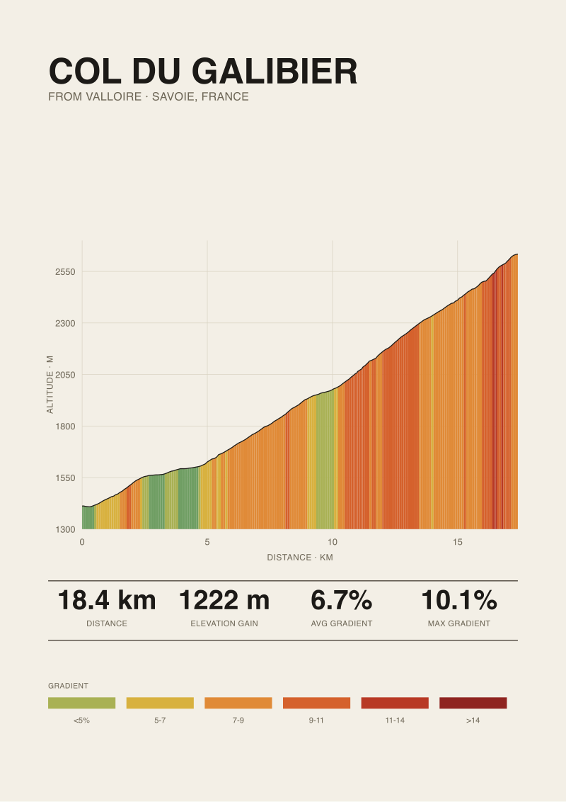 Col du Galibier
The print from this article · from €29.95
View the print →
Col du Galibier
The print from this article · from €29.95
View the print →
What Nobody Mentions: The 10.1 Percent Figure and Where It Comes From
Here is where two measurement traditions collide. The 6.7 percent average is a satellite figure. It comes from OpenTopoData's SRTM 30-metre grid, which is essentially a raster of the earth's elevation sampled every 30 metres and then interpolated along the route. It is the same class of data that powers every mainstream cycling elevation tool. It is honest, reproducible, and blind to anything narrower than 30 metres of road. When a ramp exists that is shorter than the grid can see, the ramp is averaged into its neighbours and the maximum reported gradient is softened.
The 10.1 percent published maximum, credited in the grounding to climbfinder.com for the Valloire ascent, comes from a different source class. Road-book maxima are typically derived from higher-resolution surveys, road signage, or hand-measured segments. They tell you what the steepest short stretch actually is, not what the steepest 30-metre satellite cell reports. A 10.1 percent published max is not exotic on a climb of this length, but it is significantly steeper than the 6.7 percent average would suggest, and the gap between the two figures is not sloppy record-keeping. It is the difference between what the mountain does over a whole climb and what it does at its worst moment.
None of this is a criticism of either number. The measured 6.7 percent is the correct figure for describing the total workload from Valloire to the summit. The published 10.1 percent is the correct figure for describing the worst hundred metres you will face. A reader who conflates the two, or worse, who assumes the maximum is closer to the average than it actually is, will misread the climb in both directions: they will underestimate the sting of the steepest section and overestimate the punishment of the average grade. We publish both because the mountain has both, and because pretending a satellite file and a road book are the same document does the reader no favours.
The Real Cost: How the Profile Shaped a Century of Tour de France Racing
Now the archive. The Galibier entered the Tour de France in 1911 on the first Alpine crossing the race had ever attempted, a stage across the Chamonix–Grenoble route that Henri Desgrange, the Tour's founder and hard-liner-in-chief, described in language that has been quoted so often since that its edges have worn smooth. Émile Georget was the first man over the summit. The profile we drew from the Valloire side is not the same profile the 1911 field rode, since much of the race that year approached the col from the north via the Col du Télégraphe, but the summit elevation was the same 2,634 metres, and it is the summit elevation that has done the historical work.
Everything the Tour has ever asked of the Galibier flows from that altitude and from the length of climbing that precedes it. The col has often anchored the Souvenir Henri Desgrange, the annual prize awarded to the first rider over the highest point of the Tour, precisely because 2,634 metres tends to be the highest point available. The climb has been used as a summit finish and as a mid-stage judgement, and its position in a stage matters differently than its position on any lower Alpine road. When the race sends riders over the Galibier late in a hard mountain day, the last four kilometres above 2,300 metres do work that a lower col cannot replicate.
The pattern is consistent across generations of racing. Riders do not typically crack on the Galibier because of a single steep ramp. They crack because the climb is long enough, and finishes high enough, that any accumulated fatigue from earlier cols is exposed in the thin air of the final kilometres. The profile is not a slugging match. It is an interrogation. A rider who has ridden the previous cols slightly beyond threshold arrives at the last section of the Galibier and finds out, in front of the whole race, whether the earlier bill can be paid. That structural fact, encoded in 1,222 metres of gain, 18.37 kilometres of road, and a finish at 2,634 metres, has decided more editions of the Tour than any single memorable attack.
 Alpe d'Huez
The print from this article · from €29.95
View the print →
Alpe d'Huez
The print from this article · from €29.95
View the print →
If You Only Remember One Thing
If you keep one thing from this piece, keep the pair. The Galibier is 18.37 kilometres at 6.7 percent from Valloire, and its published maximum is 10.1 percent. Those two numbers describe two different truths, both correct, and the mountain is legible only when you hold them at the same time.
The rest, the 1911 stage, Desgrange's rhetoric, the Souvenir prize, the reason cracks tend to appear in the last four kilometres, is what the sport built on top of a specific piece of geometry. The geometry came first. The stories are downstream of the profile. Any article that starts with the stories and only reaches for the numbers as decoration has the sequence backwards. If you want to hold the profile itself where you can read it every day, the Valloire ascent is available as a print in our shop.
This piece did not address the Lautaret–Galibier ascent from the south, which is a materially different climb and deserves its own measured profile rather than a paragraph borrowed from the north side. It did not address the winter road closures that shape when the col is rideable, since those are calendar facts rather than profile facts. And it did not attempt a rider-by-rider account of famous Galibier stages; that is a race-history article, and it belongs in a different desk than this one.
FAQ
How long is the Col du Galibier from Valloire, exactly?
Measured from the OpenTopoData SRTM 30-metre elevation grid, the ascent from Valloire covers 18.37 kilometres from a start elevation of 1,412 metres to a summit at 2,634 metres. That gives 1,222 metres of total vertical gain. Guidebooks sometimes round to 18 or 19 kilometres depending on where they place the base marker in Valloire; the figure we publish is the length of the actual climbing segment as the elevation file reads it.
What is the average gradient, and is the whole climb that steep?
The measured average is 6.7 percent across the full 18.37 kilometres. That figure is a mathematical average and it does not describe how the climb feels at any single moment. Long sections of the Valloire ascent sit in the high sixes and low sevens, which is where the average lives. Other stretches sit below the average, and short ramps sit well above it. The 6.7 percent number is honest, but only when read as a whole-climb summary.
Why do some sources say the maximum gradient is 10.1 percent when the average is 6.7?
Because they are measuring different things with different tools. Our 6.7 percent average is derived from a 30-metre satellite elevation grid, which cannot resolve ramps shorter than that grid cell. The 10.1 percent figure, credited in our grounding to climbfinder.com on the Valloire ascent, is a road-book maximum drawn from a higher-resolution measurement of the steepest short section. Both numbers are correct for their purpose. A whole-climb average and a worst-hundred-metres peak are simply not the same statistic.
When did the Col du Galibier first appear in the Tour de France?
The Galibier was first crossed by the Tour de France in 1911, on the race's first genuine Alpine stage. Émile Georget was the first rider over the summit. Henri Desgrange, the Tour's founder, made no secret of what he thought of the mountains as a test of the field. The summit elevation the 1911 riders reached, 2,634 metres, is the same summit elevation we measured today; the profile from Valloire has not changed in the way that matters.
What is the Souvenir Henri Desgrange, and why does the Galibier keep winning it?
The Souvenir Henri Desgrange is a prize awarded during the Tour de France to the first rider over the highest summit of the current edition. The Galibier is not the only col that has claimed it, but the mountain features often because 2,634 metres is a high summit by Tour standards and the road is included in Alpine stage design regularly. When a Tour route crosses the Galibier and no higher point is included that year, the Souvenir is decided on its slopes.
Is the Valloire side harder than the Lautaret side?
The two ascents are different climbs, and this piece only measured the Valloire side. From Valloire, the profile is 18.37 kilometres at 6.7 percent average. The southern ascent via the Col du Lautaret has a different length, gradient distribution, and starting elevation, and we would want to run the same measurement discipline against that profile before making a comparative claim. Anecdotally, riders describe the two sides as distinct experiences rather than harder-versus-easier. We would rather stay silent on the ranking than publish a comparison we have not measured.
Why does the finish of the Galibier feel harder than the average gradient suggests?
Two reasons show up in the numbers we do have. The last four kilometres of the Valloire ascent pass 2,300 metres and finish at 2,634, which is high enough for air density to affect the sensation of effort in a measurable way. Second, the Galibier is almost always ridden at the end of a long day in Tour and cyclosportive settings, so accumulated fatigue from earlier cols meets a climb whose final section does not allow recovery. The average gradient does not describe either factor.
Can I trust the SRTM 30-metre data for planning a ride?
For planning purposes, yes, with a caveat. Satellite-derived elevation grids are excellent for total length, total gain, and average gradient. They are less reliable for the very steepest short ramp on a climb, because a ramp shorter than the grid resolution gets averaged into its neighbours. If your ride depends on knowing the worst 100 metres, cross-reference a road-book source for the maximum gradient. For everything else, the SRTM profile is the most reproducible file available.
From the collection


New climbs and 10% off your first print.
One email now with your code. No noise after.