The number is 21.51 kilometres. That is the length of the Bédoin ascent of Mont Ventoux as measured from OpenTopoData's SRTM 30-metre elevation grid, from the roundabout at 317 metres in the village to the observatory at 1,892 metres on the summit. The vertical gain is 1,575 metres. Divide one by the other and the average gradient across the whole climb works out to 7.3 percent. Climbfinder's road-book figure for the maximum gradient is 12 percent. We pulled the profile, sat with it for a morning, and decided the road-book number is the least interesting thing on the page.
What the Numbers Actually Say
Start with the four figures that anchor everything else: 317 metres at the base, 1,892 metres at the top, 21.51 kilometres between them, 1,575 metres gained along the way. Those are the receipts. Every other claim we make about this climb has to be reconciled against them, and the moment a claim drifts free of those numbers, it becomes something else — folklore, memory, marketing.
The 7.3 percent average is a division, not a description. It tells you what would happen if a road engineer resurfaced the entire climb tomorrow at a perfectly uniform grade: you would have exactly the same start elevation, exactly the same summit, and exactly the same total distance, with a ramp of 7.3 percent all the way up. That road does not exist. What exists instead is a climb that is nearly flat for the first six kilometres out of Bédoin, then goes to work.
The interesting arithmetic starts when you look at the residual. If the first stretch out of the village is genuinely gentle — a plausible reading of the profile — then the remaining 15 or so kilometres up through the forest and out into the lunar shale above Chalet Reynard have to average considerably more than 7.3 percent to make the summit figure balance. That is not a rhetorical claim. It is a bookkeeping identity. Total gain is fixed at 1,575 metres. Total distance is fixed at 21.51 kilometres. If any portion undershoots the average, another portion has to overshoot it, and the size of the overshoot is set by the length of the undershoot.
This is the layer where most descriptions of Ventoux stop being useful. They quote the 21.51 and the 7.3 percent as a headline pair, then jump directly to the summit temperature and the wind and Tom Simpson. The middle — where the climb actually happens — gets skipped. That middle is where our print starts to disagree with everything else in your search results.
The elevation source matters here. OpenTopoData's SRTM 30-metre grid is a satellite-derived digital elevation model, sampled roughly every 30 metres of ground distance. It sees the top of the tree canopy in the forest section and the bare stone above it, and it does not know about the exact camber of a hairpin. It is honest about what it is: a measured elevation surface, not a road-book. The 21.51 kilometres and 1,575 metres are what that surface says, computed cleanly from a start point to an end point along the road's ground track.
What Nobody Mentions
The 12 percent maximum published by Climbfinder is the number that gets copied into most Ventoux write-ups, because road-books are what most Ventoux write-ups draw from. Road-books are useful. They are also not measurements. They are consensus figures, typically representing the steepest 100-metre stretch a surveyor identified on the road itself, and they are rounded, revised, and inherited across guides in a way that makes the exact provenance hard to trace.
Set the road-book aside for a moment and think about what a 12 percent maximum implies against a 7.3 percent average across 21.51 kilometres. It implies a climb in which the peaks of the gradient never rise more than about 4.7 percentage points above the mean. That is a gentle description of Ventoux. Anyone who has read the profile — or ridden it — knows that the forest above Saint-Estève is not gentle. The road pins itself into a straight ramp through the pines, and it does not release you until Chalet Reynard, roughly ten kilometres of climbing that sits well above the whole-climb average for essentially its entire length.
The road-book 12 percent is defensible. It is also small. It is the number a guidebook can quote confidently across the whole ascent because it is the highest sustained stretch anyone has cared to formally survey. It is not the number that describes what the road does. Those two are not the same thing, and the gap between them is where most first-time Ventoux riders discover they are on a different climb than the one their spreadsheet described.
The second thing nobody mentions is that Ventoux from Bédoin is structurally two climbs stapled together at Chalet Reynard, near 1,417 metres. Below Reynard you are in the Provençal forest, hot, still, no view, gradient relentless. Above Reynard the trees end, the temperature usually drops, the wind takes over, and the road eases fractionally before the final push to the observatory. The full-climb 7.3 percent averages these two very different environments into a single number that does not describe either of them accurately.
The third thing nobody mentions is the start elevation. 317 metres. That is Provence — low, warm, at sea-level's cousin. You gain 1,575 metres from there. There are longer climbs in the Alps and there are climbs that finish higher, but there are not many roads that ask you to lift yourself 1,575 vertical metres above your starting point in one continuous effort from that low a base. The altitude range matters because the air changes on you. You begin the climb in Mediterranean heat and finish it in weather that behaves like the Alps in miniature.
 Mont Ventoux
The print from this article · from €29.95
View the print →
Mont Ventoux
The print from this article · from €29.95
View the print →
The Real Cost
Put the cost in the currency the profile actually charges: vertical metres per kilometre, sustained.
If the first six kilometres out of Bédoin average, generously, around 4 percent, they contribute roughly 240 metres of gain. That leaves 1,335 metres to be gained across the remaining 15.5 kilometres. The average gradient of that remainder is 8.6 percent, sustained, for roughly ninety minutes to two hours of climbing depending on your engine. Not the peak. The average, of a fifteen-kilometre segment. That is a very different climb from the one the 7.3 percent headline implies.
Now translate the arithmetic into what happens to a rider. A steady 8.6 percent for ninety minutes is not a stretch you dance up. It is a stretch where the pedal stroke becomes a metronome, gearing choice becomes the only tactical decision you have left, and you spend the second hour of it recalculating how much water you have. The 12 percent road-book maximum tells you almost nothing about that hour. What tells you about it is the sustained figure — the average of the hardest continuous portion, not the crest of the hardest individual ramp — and that number is closer to nine than to seven.
The cost above Chalet Reynard is different in kind, not degree. The gradient there is often quoted as fractionally easier than the forest, which is broadly consistent with the profile. What is not quoted is that the last six or so kilometres to the summit are exposed to a wind that regularly exceeds any headwind you have ridden into on a road climb, and that the road surface has no visual reference points to gauge progress against. You climb through a landscape that looks like the moon photographed in bright daylight, and the summit tower appears at essentially the same apparent distance for the final forty minutes of the ascent. The gradient is the smaller of your two problems in that stretch.
Reconciling all of this back to the receipt: 21.51 kilometres, 1,575 metres, 7.3 percent average. Every one of those numbers is correct. None of them, on its own, prepares you for the actual shape of the road. The shape is: gentle warm-up, brutal sustained forest, exposed alpine finish. The single-number average flattens all three into a figure that reads like a hard-but-manageable Category 1. Ventoux from Bédoin is not that climb. It is a climb whose average gradient is a summary statistic and whose reality is the distribution behind it.
This is the case, in our view, for looking at the profile before booking the trip. Not the road-book. Not the summary card. The profile itself, printed at a size where the shape of the road tells you what the numbers cannot. That is the print we make, and it is the reason we make it — a full-scale Ventoux from Bédoin elevation print sits on the wall as a permanent reminder that the average is not the argument. The distribution is.
If You Only Remember One Thing
The Bédoin ascent of Mont Ventoux is 21.51 kilometres long, gains 1,575 metres, and averages 7.3 percent. Those three numbers are exact, they come from a 30-metre satellite elevation grid, and they are the only unambiguous facts about this climb.
The 12 percent maximum you will see quoted comes from a road-book, not from the same measurement, and it tells you less than the shape of the profile does. If you plan the ride around the average, you plan for the wrong climb. If you plan around the sustained middle — the forest above Saint-Estève, where the gradient sits well north of the whole-climb figure for kilometres at a time — you plan for the climb that is actually there.
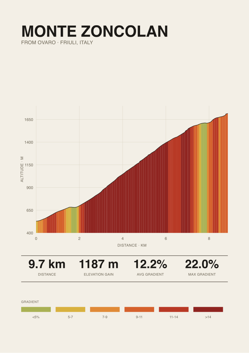
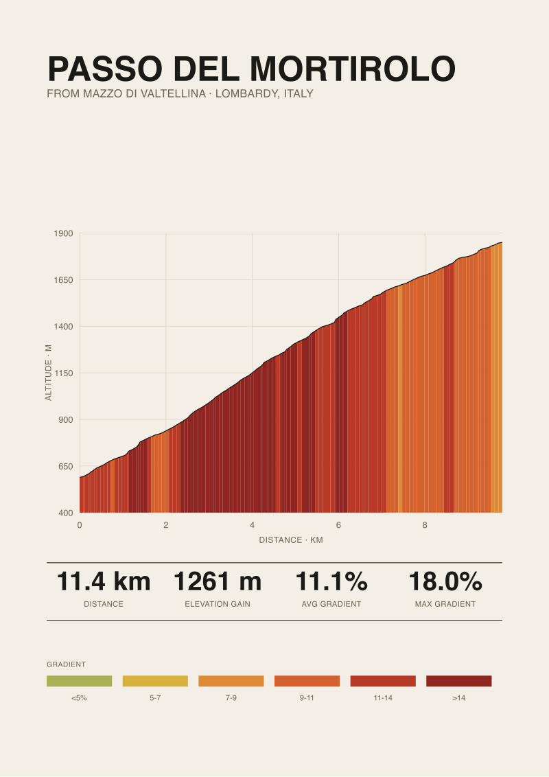
Which leaves the next question, and it is not one this piece is going to answer: given that the road-book maximum and the measured profile disagree in interesting ways on Ventoux, how far does that disagreement extend across the other legendary climbs? The Angliru, the Zoncolan, the Mortirolo — every one of them has a published maximum that has been inherited across guidebooks for decades, and a satellite-measured profile that does not always agree. That is the work we do next, and it is not where this piece ends.
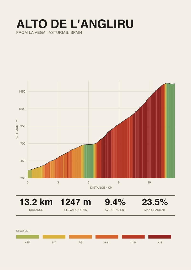 Alto de l'Angliru
The print from this article · from €29.95
View the print →
Alto de l'Angliru
The print from this article · from €29.95
View the print →
From the collection

New climbs and 10% off your first print.
One email now with your code. No noise after.