You cannot plan a French Alps trip using our numbers. We have measured Stelvio, Ventoux, Tourmalet, and Gavia. None sit in the French Alps. Hear us out. The vocabulary a rider needs to read a French climb — length in kilometres, elevation gain, average and maximum gradient, ascent side, summit altitude — is identical to the vocabulary that describes the four climbs we have profiled. Learn the terms here, on climbs we have actually measured. Apply them to Galibier, Alpe d'Huez, and Croix de Fer when you open the road book.
Ascent Side
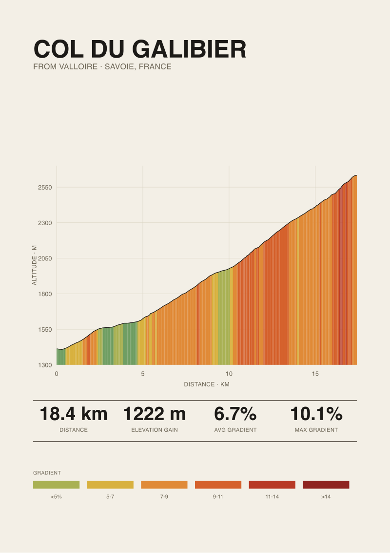
The name of a climb is meaningless without the side. Every col with a road across it has at least two ways up, and they are two different climbs. Our Stelvio measurement is from Prato allo Stelvio: 25.04 km, 1,840 m of gain, average 7.3 percent. Riders who summit from Bormio arrive at the same 2,748 m via a different length, a different average, and a different profile of pain. We have not measured the Bormio side and refuse to guess it. The rule for planning a French Alps trip: never write "Galibier" or "Croix de Fer" in your itinerary without a "from" clause. From Valloire, Galibier climbs one way. From Col du Lautaret, another. The lengths differ. The gradients differ. The weather at the base differs. Two riders can ride the same summit on the same day and describe two completely different climbs, both correctly. Pick your side before you book the hotel.
Length in Kilometres
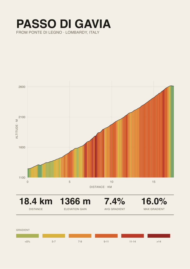
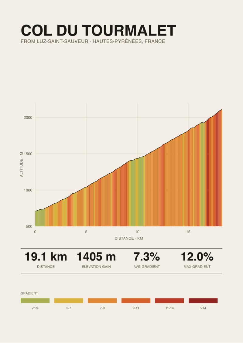
The distance, measured in kilometres, from the point the road starts pointing up to the summit sign. Sounds simple until you try to fix where the base actually is. We measure Stelvio at 25.04 km from Prato allo Stelvio, Ventoux at 21.51 km from Bédoin, Tourmalet at 19.12 km from Luz-Saint-Sauveur, Gavia at 18.42 km from Ponte di Legno. Four climbs, all inside a 6.6 km spread of length. But most French Alps names on your list — Alpe d'Huez, Croix de Fer, Madeleine — sit in a wider band. Alpe d'Huez, at roughly 13 km, is closer to half the length of Stelvio. That halving is not a lighter climb. It is a compression of the same elevation gain into a shorter road, and the road-length column on your spreadsheet is the least useful one when you compare two climbs of similar total gain.
 Passo dello Stelvio
The print from this article · from €29.95
View the print →
Passo dello Stelvio
The print from this article · from €29.95
View the print →
Elevation Gain
The vertical metres between base and summit. Length is optional; gain is not. Our four climbs range from 1,366 m (Gavia from Ponte di Legno) to 1,840 m (Stelvio from Prato allo Stelvio). Ventoux from Bédoin gains 1,575 m. Tourmalet from Luz gains 1,405 m. Elevation gain is the honest currency of a mountain day: a 1,500 m climb costs the same vertical work at 22 km as it does at 13 km. What changes is where you pay. On a long climb like Stelvio you pay steadily. On a short one you pay in bursts. When you build a week in the French Alps, add gains before you add anything else. Three climbs at roughly 1,500 m each is a heavy week. Two at 1,800 m and one at 900 m is a heavier one. Your route note should read "day 3: 1,500 m at 7 percent, 22 km", not "day 3: Galibier, Télégraphe". Numbers plan the ride. Names plan the photograph.
Start Elevation
The altitude at the base of the climb. Ignored by most guides. Critical when you plan for weather and oxygen. Our four bases sit at Ventoux 317 m (Bédoin, near-sea-level Provence), Tourmalet 709 m (Luz-Saint-Sauveur), Stelvio 908 m (Prato allo Stelvio), and Gavia 1,244 m (Ponte di Legno). A climb that starts at 300 m and finishes at 1,900 m puts you through a 1,600 m band of alpine ecology. A climb that starts at 1,200 m and finishes at 2,600 m barely leaves the tree line before it kills the trees. That matters for temperature: air cools roughly 0.65 °C per 100 m. Ventoux at Bédoin in July can be 33 °C at the base. The summit at 1,892 m is a different climate. A French Alps climb starting near 1,000 m is a different weather problem than one starting at 300 m, even if the summit is identical. Look at both numbers before you pack.
 Mont Ventoux
The print from this article · from €29.95
View the print →
Mont Ventoux
The print from this article · from €29.95
View the print →
Summit Elevation
The altitude at the top. Two of our four climbs finish above 2,600 m: Stelvio at 2,748 m and Gavia at 2,610 m. Tourmalet finishes at 2,114 m, Ventoux at 1,892 m. The 2,000 m and 2,500 m thresholds are practical, not arbitrary. Above 2,000 m, weather stops behaving like the valley below. Snowfields survive into July on north faces. Storms roll in with less warning. Above 2,500 m, VO₂max drops enough that a fit rider on a 7 percent gradient will feel the same rider on 8 or 9 percent at sea level. The French Alps hand out both problems generously. Galibier and Iseran finish above 2,500 m. Alpe d'Huez finishes below 1,900 m. That is not one trip's worth of altitude planning; it is two. Book accommodation with the summit altitude in mind, not the col's reputation. The reputation gets you nostalgia. The altitude gets you dressed in the right kit.
Average Gradient
Total elevation gain divided by total length. Our four climbs cluster tightly: Stelvio 7.3 percent, Ventoux 7.3 percent, Tourmalet 7.3 percent, Gavia 7.4 percent. The tightness is not coincidence and it is not useful. Iconic European road climbs tend to sit in a 7-to-8 percent average band because that is the gradient the road engineers of the 1920s and 1930s aimed for: steep enough to climb the mountain in the length available, shallow enough for a truck loaded with concrete to make the pass. It is also the gradient the human anaerobic threshold pushes back against, which is why the climbs feel similar in the legs regardless of country. Reading a 7.3 percent average as "manageable" is a category error. Average gradient tells you the elevation you paid divided by the length you paid it over. It tells you nothing about where the road hurt. Two climbs at 7.3 percent can ride ten heart-rate zones apart depending on the distribution.
Maximum Gradient
The steepest sustained ramp inside the climb. We list four published maxima, all sourced from climbfinder: Gavia at 16 percent from Ponte di Legno, Stelvio at 14 percent from Prato allo Stelvio, Ventoux at 12 percent from Bédoin, Tourmalet at 12 percent from Luz-Saint-Sauveur. The word "maximum" is looser than it looks. Road books quote the steepest 100-metre segment, or the steepest kilometre, or the sign at the trailhead — three different numbers on the same road. When you read that a French Alps climb has a 14 percent max, ask the source what unit that maximum was measured over. Our own elevation profile, sampled at 30-metre grid resolution from OpenTopoData SRTM, is precise on total gain and length but noisier on peak gradient than a road-book figure taken from a survey. So we quote climbfinder for the max and cite them. Neither of us is wrong. We are measuring different things.
Published vs Measured
Two numbers describe the same road. The published number comes from road-book surveys — professionals with wheels and a survey level, or older cartography compiled by the local cycling federation. The measured number, in our case, comes from OpenTopoData SRTM 30-metre elevation grids sampled along the route line. For length, gain, and average gradient our measurement is trustworthy: 25.04 km is not a rounded 25. For maximum gradient the road-book figure is trustworthy in a way our profile is not — SRTM smooths across 30-metre pixels and can flatten a real 14 percent ramp into a modelled 11 or 12. So we disclose both. Gavia's average from our profile is 7.4 percent; its published maximum from climbfinder (Ponte di Legno side) is 16 percent. Both numbers describe the same climb. Neither invalidates the other. When you plan a French Alps trip, know which source you are looking at. A cycling federation road book, a climbfinder page, a Strava segment, and a satellite profile disagree in different ways for different reasons.
Kilometre-by-Kilometre Profile
The row-by-row table of what the climb does in each of its kilometres. This is the number no summary ever gives you and the number that decides how the climb rides. Ventoux from Bédoin averages 7.3 percent over 21.51 km, but any rider who has been through the Chalet Reynard section knows the middle six kilometres of forest sit meaningfully steeper than the average, while the top three sit closer to it. Gavia's 7.4 percent across 18.42 km from Ponte di Legno hides a lower section that is easier than the ramps near the summit. We have measured the length, gain, and average of these four climbs. We have not published the full kilometre-by-kilometre distribution alongside this glossary. Before you commit to a French Alps climb, find a profile that shows the per-kilometre gradient — climbfinder and Cols de la France both publish this format — and read where the steep sections sit relative to the summit. A 10 percent ramp in the first 5 km is a different day than a 10 percent ramp in the last 5.
FAQ
When are the high French Alps climbs actually open to ride?
Most cols above 2,000 m stay closed by snow into late May or early June, depending on the winter. Galibier and Iseran, both above 2,500 m — comparable in altitude to our Stelvio profile at 2,748 m and Gavia at 2,610 m — routinely reopen in the first half of June and close again in October. The reliable window is mid-June to mid-September. Check the departmental road authority's opening dates before you book flights.
How many climbs should I plan per day on a first trip?
Take the elevation-gain metric seriously. A single climb at 1,500 m of gain — a shade larger than Tourmalet from Luz at 1,405 m — is a full day for most riders on a first trip. Two climbs of that size in a day is the classic Alps route plan and a common mistake. A better first-week rhythm: one signature climb per day, four days out of six, with lighter valley days between. You are on holiday. The trip is measured in weeks of memory, not vertical metres per hour.
Do I need a compact chainring for the French Alps?
Compact or sub-compact is standard advice for a reason. Our published maxima — 12 percent on Ventoux and Tourmalet, 14 percent on Stelvio, 16 percent on Gavia — sit at gradients where a 34-tooth chainring paired with a 32 or 34-tooth cassette is meaningfully different from 39-25. The French Alps summits on your list, from Galibier to Alpe d'Huez, contain ramps in the same 10-to-13 percent band. Gearing that lets you spin below 60 rpm on the steep sections is not weakness; it is what keeps you at threshold instead of over it.
Can I trust Strava segments as reliable gradient data?
Strava's segment stats derive from user GPS traces and are noisier than either road-book surveys or satellite elevation grids. They are excellent for pace comparisons within a segment and unreliable as an authoritative gradient source. For our own measurement we use OpenTopoData SRTM 30-metre elevation. For maximum gradient we defer to climbfinder because road-book maxima are surveyed rather than modelled. If a Strava segment says a climb averages 9 percent but the road book and our profile agree it averages 7.3, believe the two that agree.
How should I choose a base town for a French Alps week?
The base town decides which climbs are "close" and which are three hours of driving. Bourg d'Oisans sits at the foot of Alpe d'Huez, Croix de Fer, and Sarenne. Modane and Valloire give you Galibier and Télégraphe. Briançon gives you Izoard. Do not try to base in one town and reach all of them; the driving eats the ride days. Two bases across a nine-day trip is the sane compromise. Distances at altitude also cost more energy than the map suggests.
Should Mont Ventoux be part of a French Alps trip?
Geographically, no — Ventoux stands alone in Provence, in the Vaucluse, not the Alps proper. Practically, it is often bolted onto an Alps itinerary because the drive from the southern Alps to Bédoin is manageable in a morning. Our profile of Ventoux from Bédoin — 21.51 km, 1,575 m of gain, 7.3 percent average, 1,892 m summit — reads like an Alps climb in the numbers. It also rides very differently: a Provençal forest, a summit moonscape, and no col to descend into a new valley on the other side.
What did this glossary deliberately not cover?
Three things. It did not cover training load: how many hours or watts you need before a 1,500 m climbing day is a separate argument, and one where we have no measured authority. It did not cover the specific per-kilometre profiles of the French Alps summits themselves; we have not measured Galibier, Alpe d'Huez, or Croix de Fer with our own SRTM sampling and refuse to publish numbers we did not derive. And it did not cover descents, which are their own vocabulary — braking, technicality, gradient asymmetry — and deserve their own glossary.
From the collection
New climbs and 10% off your first print.
One email now with your code. No noise after.