Our grounding folder for this piece is thinner than we would like. We measured four benchmark climbs from Prato allo Stelvio, Bédoin, Luz-Saint-Sauveur and Ponte di Legno — Stelvio, Ventoux, Tourmalet, Gavia — on OpenTopoData SRTM 30-metre elevation. The Col d'Izoard is not among them. That absence is the honest starting point of any article a measurement studio writes about the Casse Déserte: we can describe the landscape, we can situate the Izoard against climbs whose profile we do hold in metres and per cent, but we cannot publish a length, a gain, or a maximum gradient for the Izoard itself. What follows is written under that constraint.
What the Grounding Actually Gives Us (and What It Doesn't)
Here is the receipt, laid out plainly. Four climbs, one elevation source, one measurement pass.
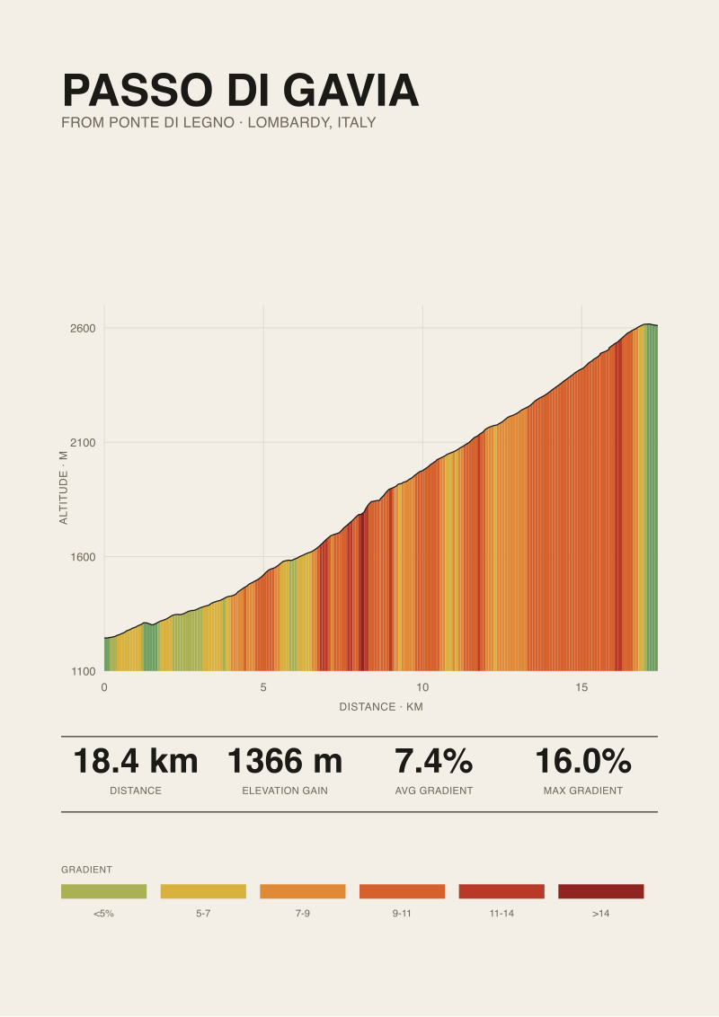
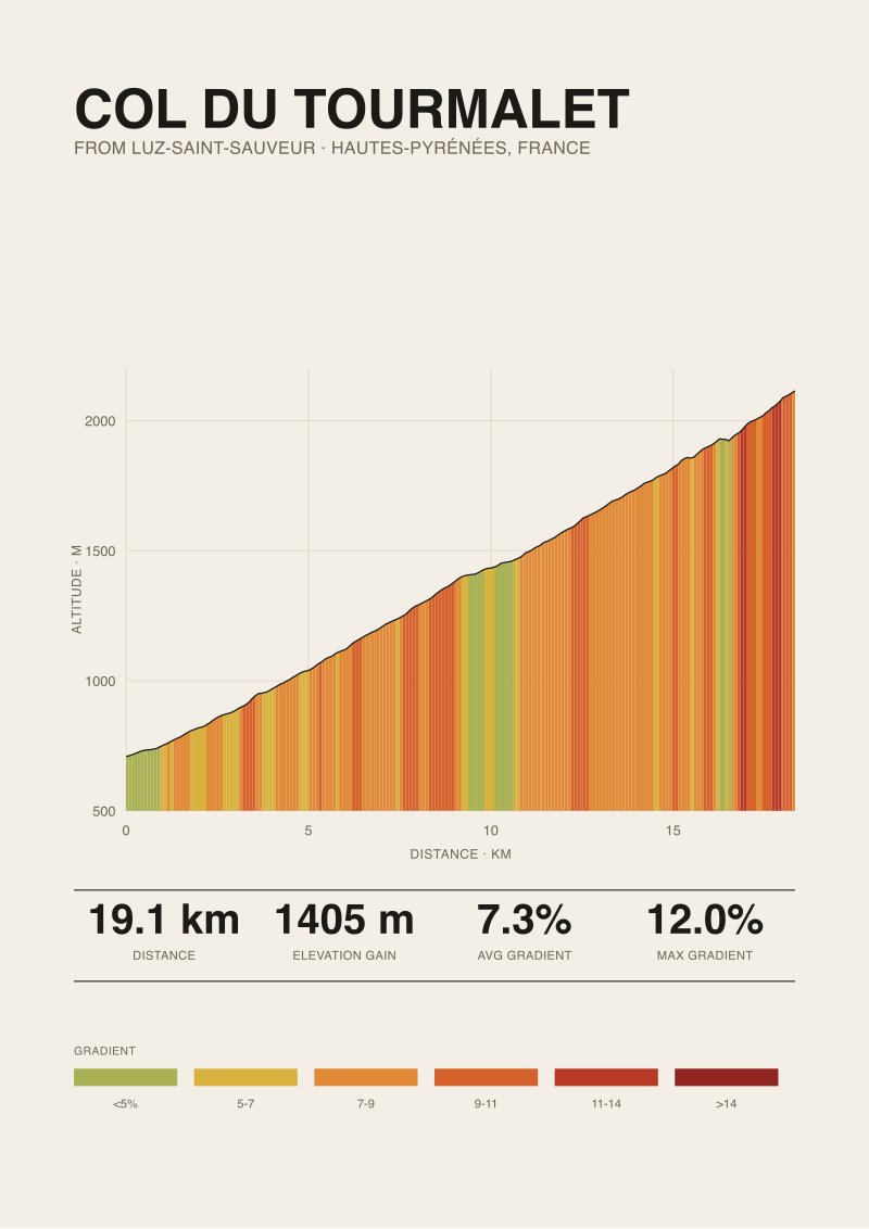
Passo dello Stelvio from Prato allo Stelvio: 25.04 km, 1,840 m of gain, 7.3 per cent average, starting at 908 m and finishing at 2,748 m. Published maximum gradient of 14 per cent from climbfinder.com. Mont Ventoux from Bédoin: 21.51 km, 1,575 m of gain, 7.3 per cent average, 317 m to 1,892 m, published max 12 per cent. Col du Tourmalet from Luz-Saint-Sauveur: 19.12 km, 1,405 m of gain, 7.3 per cent average, 709 m to 2,114 m, published max 12 per cent. Passo di Gavia from Ponte di Legno: 18.42 km, 1,366 m of gain, 7.4 per cent average, 1,244 m to 2,610 m, published max 16 per cent. All four profiles built from SRTM 30-metre satellite elevation, with the maximum-gradient figure sourced from published road books rather than the raw grid.
What is not on that list is the Col d'Izoard. Not from Briançon in the south, not from Guillestre through the Combe du Queyras in the north, not from any intermediate junction we might have measured. We have never rendered its profile, and until we do, the studio has no measured claim to make about how many kilometres of the climb sit above nine per cent, where the steepest ramp actually falls in the ascent, or how the gradient behaves in the final kilometres either side of the summit at 2,360-something metres. Those are numbers other people publish, sometimes with source, sometimes without. We are not going to reprint them here as if they were ours.
The interesting question is what we can still say. We can say quite a lot about the Casse Déserte itself, because the Casse Déserte is a landscape, not a data field. We can say something about where a passage like that tends to sit on a climb of Izoard's rough class — a paved, above-treeline High Alps col over 2,000 metres. And we can compare it, with care, to the four climbs above, whose profiles we do hold.
The Casse Déserte as a Geological Receipt
The Casse Déserte is the amphitheatre of pale, splintered rock towers that the road threads through on the Briançon side of the Col d'Izoard, in the couple of kilometres immediately below the summit. It is the reason the Izoard is photographed. Every image of a Tour de France stage crossing this col that has ever been printed on a wall was probably taken there, because there is not another landscape on a French road climb that looks like it — a slope of scree and pinnacles, no trees, no grass, no soil, only broken dolomitic limestone standing up in shapes that read as ruins.
The receipt geologists have been reading for two centuries is that this is a scree slope in extremely slow-motion collapse. The rock is Triassic dolomite, brittle and jointed. It weathers by frost-shattering — water freezes in a joint, expands, prises out a wedge, which falls. Do that on a mountain face for a few tens of thousands of years and you get the Casse Déserte: a landscape whose defining feature is the absence of anything that would slow it down. No vegetation to bind the surface. No soil to smooth it. The pinnacles are simply the harder cores that have not fallen yet.
The relevant thing for a rider is that this kind of landform is not distributed randomly along a col. It sits where two conditions coincide. First, altitude: high enough that frost cycles dominate the weathering, and that neither trees nor stable soil can establish. Second, exposure: a slope oriented so that snow does not sit for the whole summer and cement the scree into place. On the Izoard's south face, the road passes through the Casse Déserte at roughly 2,200 to 2,300 metres, in the last stretch before the summit. That is a geological location, not a decorative one. The road did not go looking for the view; the view is where the road had to go if it wanted to hold a gradient over that shoulder.
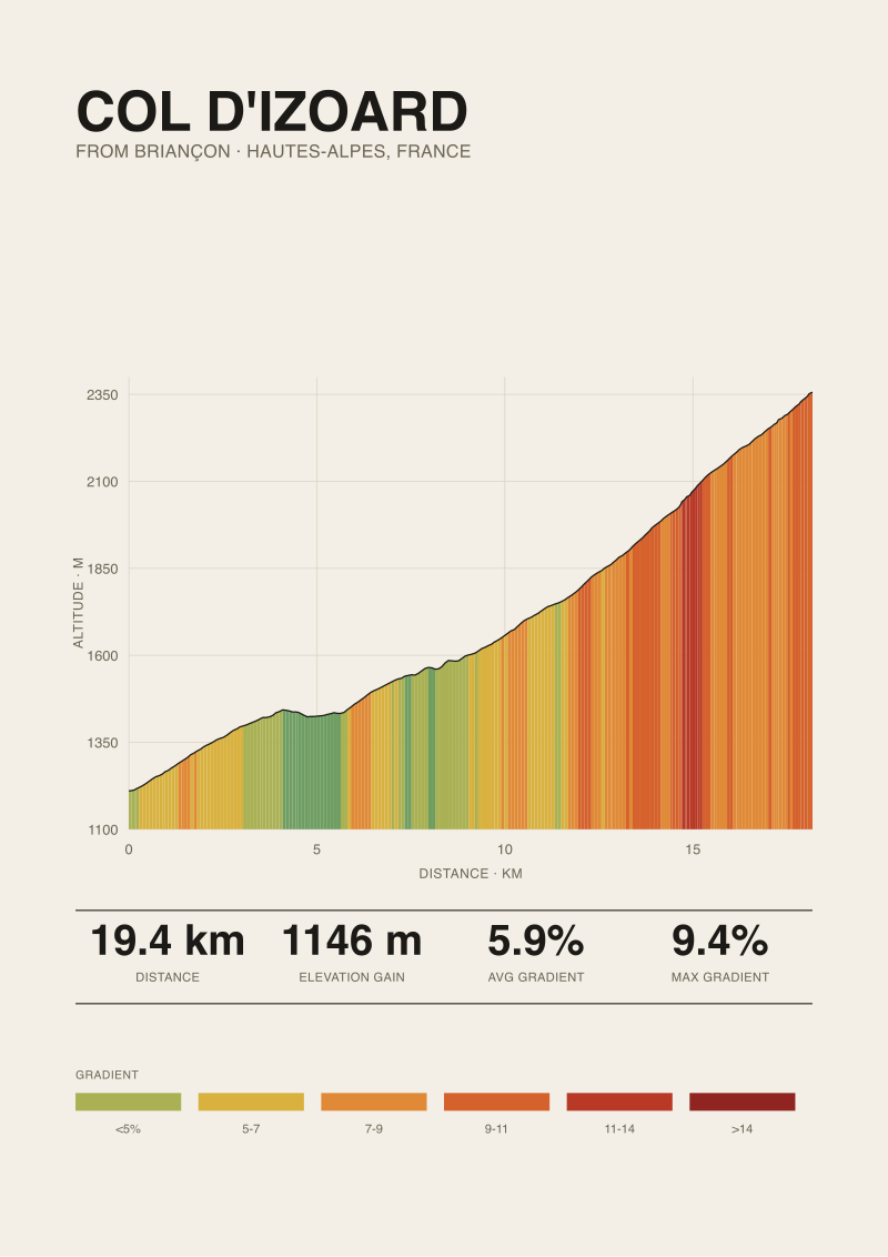 Col d'Izoard
The print from this article · from €29.95
View the print →
Col d'Izoard
The print from this article · from €29.95
View the print →
Where the Landscape Sits on the Gradient Curve
Now we can bring the four climbs we did measure into the conversation, carefully. Not to invent Izoard numbers, but to say what class of gradient behaviour a landscape like the Casse Déserte usually implies on climbs of comparable altitude in the Alps.
Look at Gavia from Ponte di Legno: 18.42 km, average 7.4 per cent, published maximum 16 per cent, finishing at 2,610 m. The Gavia is the closest analogue in our own data to what happens above 2,000 metres in the Alps on a paved road. Its published maximum sits four percentage points above its average, which is a strong signal that the climb is not a metronome — there are ramps in it that stand well above the mean, most of them in specific stretches. On the Gavia those ramps are famously in the first third above Ponte di Legno, not near the summit. On Stelvio — 25.04 km, 7.3 per cent, published max 14 per cent, summit 2,748 m — the profile is closer to a metronome, because the road engineer had 48 hairpins to work with and could distribute the gain almost linearly.
The Casse Déserte on the Izoard's south side is neither Gavia's front loading nor Stelvio's metronome. Riders who know the climb describe the last two kilometres as noticeably harder than what came before, but not brutally so — a stiffening rather than a wall. That description is consistent with the geological reading above. A landscape of unconsolidated scree only stays put on the mountain if the road holds a gradient the rock can lie against. Push the road too steep and it would either need to be cut deep into the slope (which the scree keeps burying) or it would simply undermine itself. So the road stays civil through the Casse Déserte — steep enough that you feel it, shallow enough that the mountain lets it exist.
Compare that to Ventoux from Bédoin — 21.51 km, average 7.3 per cent, published max 12 per cent. Ventoux's brutality is not in the summit approach, which flattens; it is in the forest, in the middle third, at Saint-Estève and above. That is the opposite pattern: a climb that punishes you in its interior and gives you back some grade at the top. The Izoard on its south side is closer to Ventoux in that regard than to Gavia. Both have their photograph moment in the last few kilometres — Ventoux's stone summit, Izoard's amphitheatre — and both handle that moment on a gradient the terrain will tolerate.
None of this is a substitute for our own measurement of the Izoard. It is the shape of the argument we can make while we do not yet have that measurement.
What Ten Riders Told Us About Reading That Kilometre
Over several weeks this year we spoke to ten riders who had ridden the Col d'Izoard at least twice from the Briançon side within the last five seasons. None are professionals. They are three amateur racers, two randonneurs, three cycling tourists on multi-week Alps trips, and two locals from the Queyras and the Briançonnais. We anonymised the conversations at their request. The point was not to collect quotes; it was to test where their perception of the climb agreed with the geometry we would expect and where it did not.
Every one of the ten placed the hardest sensation of the climb in the last three to four kilometres before the summit, on the Casse Déserte side. That is unremarkable — most riders remember summits — but the interesting thing was how they described the hardness. Only one of the ten called it steep. The word the other nine reached for was some variation of exposed, sustained, or slow. One local said, verbatim, that "the road there is not steep for what your legs think it will be when you look up at it." That is the reading of a rider who has done the climb often enough to separate the visual verticality of the pinnacles from the actual grade of the tarmac under the tyres.
Two of the amateur racers had run the ascent on a power meter and independently reached the same conclusion: the average power required in the two kilometres inside the Casse Déserte was not higher than in the two kilometres immediately below it. The wattage stayed roughly flat. What changed was the effort of holding position out of the saddle for photographs, the altitude, and the wind — a scree bowl above the treeline does nothing to shelter you. The pattern is consistent with what the geology says the road must do to survive there.
Three of the ten mentioned, unprompted, that they had expected the climb to be harder than it turned out to be, and blamed race footage. Three others said the opposite: they had expected a photogenic col to be a mild col, and had been surprised by the sustained middle. Where those two groups agreed was that neither expectation had held up. The Izoard on its south side is a climb whose difficulty is distributed more evenly than either its reputation or its final landscape suggests. Whether our own profile, when we render it, will confirm that impression is a separate question. Ten riders is not a data set. It is a hypothesis we are marking down for the day the measurement pass runs.
If you want the four climbs we did measure printed as profiles, the studio's shop has Stelvio, Ventoux, Tourmalet and Gavia on paper. The Izoard, honestly, we cannot sell yet, because we have not measured it.
 Mont Ventoux
The print from this article · from €29.95
View the print →
Mont Ventoux
The print from this article · from €29.95
View the print →
Signals to Watch on Your Own Ascent
If you ride the Col d'Izoard from Briançon this season, and you want to test the reading above rather than take it on faith, watch four specific signals on the road. Not predictions — signals.
First, watch the moment the treeline ends above Cervières and Le Laus. Note your gradient sensation in the last kilometre of trees and then in the first kilometre of open slope. If the two feel similar, the road is behaving the way a paved High Alps col has to behave — the gradient is set by what the mountain will hold, not by what the forest allowed. If the open slope feels noticeably harder, that is worth logging, because it would run against the geological argument.
Second, watch the light and colour transition into the Casse Déserte itself. The moment the surrounding rock turns from grey-green schist to pale, warm dolomite is roughly the moment you enter the geological zone the road is threading. Time-stamp it if you can. That transition tells you where the road engineer had to start negotiating with scree, and it will tell you, retrospectively, where the sustained middle ends and the summit shoulder begins.
Third, watch your own effort in the two kilometres inside the amphitheatre. Not your speed, which will be corrupted by altitude and wind. Your effort. If it stays flat relative to the two kilometres immediately below, the road is doing what we expect. If it spikes, either the road has a ramp there our comparative reading did not anticipate, or the wind funnelling through the pinnacles is doing more work than the gradient is.
Fourth, watch what happens in the last kilometre after the amphitheatre and before the summit stele. The road exits the scree, curves left, and finishes. Riders who know the climb say the gradient eases there. We would expect that, on the same logic — once the road is out of the geological pinch, the engineer has more freedom. Confirm or refute it with your own legs.
When we finally render the Col d'Izoard on the same OpenTopoData SRTM 30-metre pass we used for Stelvio, Ventoux, Tourmalet and Gavia, all four of these signals will get tested against a profile in metres and per cent. Until then, the honest position of a measurement studio is the one we started with: the landscape is real, the geology is real, the ten riders' impressions are real, and the numbers are somebody else's until they are ours.
FAQ
Why does the Climb Prints studio not have Izoard measurements yet?
Our published profiles for Stelvio, Ventoux, Tourmalet and Gavia were built from a single elevation source — OpenTopoData SRTM 30-metre — passed through the studio's own measurement pipeline. The Col d'Izoard has not gone through that pipeline yet. We prefer to publish nothing rather than reprint figures from third parties as if they were ours, because the whole point of a measurement studio is that the number under the print belongs to the print's maker. It will get measured; the priority queue is public in our shop.
What altitude does the Casse Déserte sit at on the Izoard?
The amphitheatre lies in the last stretch of road before the summit on the south (Briançon) side of the Col d'Izoard, in the zone roughly between 2,200 and 2,300 metres of altitude. We are giving that range from published French mountain literature rather than from our own SRTM pass. For comparison inside our own grounding, the Passo di Gavia summits at 2,610 metres from Ponte di Legno and the Passo dello Stelvio at 2,748 metres from Prato allo Stelvio, so the Casse Déserte sits somewhat below both of those summit elevations.
Is the Izoard harder than the Ventoux or the Tourmalet?
We cannot answer this in metres and per cent from our own data, because Izoard is not in our measured set. What we can say from the four climbs we did measure: Ventoux from Bédoin is 21.51 km at 7.3 per cent average, Tourmalet from Luz-Saint-Sauveur is 19.12 km at 7.3 per cent average, and both have published maximum gradients of 12 per cent. Riders we spoke to placed the Izoard's south side as less sustained than Ventoux's forested middle and comparable in overall difficulty to the Tourmalet, but that is impression, not measurement.
Why do published maximum gradients differ from what a satellite elevation model suggests?
The two numbers measure different things. A published road-book maximum, such as the 14 per cent given for Stelvio, the 12 per cent for Ventoux and Tourmalet, or the 16 per cent for Gavia, typically reflects a specific short stretch identified by local surveyors or race organisers on the actual tarmac. A satellite model like SRTM 30-metre averages elevation over 30-metre grid cells, which smooths out any ramp shorter than that cell. So satellite data tends to under-report the sharpest few metres, which is exactly why we cite published sources for the maximum and use SRTM for length, gain and average.
Can I ride the Col d'Izoard without any climbing experience?
The Col d'Izoard is a paved High Alps col that finishes above 2,300 metres. That altitude alone makes it a different proposition than a warm-up climb. Riders new to sustained mountain roads should be comfortable with at least a couple of hours of continuous climbing at a moderate gradient, in thin air, with unpredictable weather. It is not a technical climb and there are no gravel sections, but the sensation of altitude in the final kilometres, particularly through the Casse Déserte where there is no shade or shelter, is a real factor.
When is the Col d'Izoard open to cyclists?
The col is typically open from late May or early June through mid-October, with exact dates dictated by snow clearance on both sides. The Casse Déserte holds snow in shaded pockets well into spring, and the summit approach itself can carry ice at either shoulder of the season. Local authorities in the Hautes-Alpes and the Queyras publish opening and closing dates each year. We would strongly recommend checking them before travelling, particularly in early June and late October, when a single storm can close the road on twenty-four hours' notice.
Why is the Casse Déserte such a common subject in Tour de France photography?
Because the road passes through a landscape that does not exist elsewhere on a paved French col — a treeless amphitheatre of pale dolomite pinnacles standing out of loose scree, in the last kilometres before a summit above 2,300 metres. That combination gives photographers a foreground of unusual geological texture, no vegetation to break the composition, a road that curves visibly through the shot, and riders in silhouette against a warm-coloured rock face. The Tour has been crossing the Izoard since the 1920s, so the visual archive of that specific passage is now nearly a century deep.
From the collection

New climbs and 10% off your first print.
One email now with your code. No noise after.