How did twelve reputable sources end up describing the same mountain in twelve slightly different ways? We measured the Valloire ascent of the Col du Galibier from SRTM 30-metre satellite elevation data and got 18.37 kilometres of road for 1,222 metres of vertical gain, starting at 1,412 metres and topping out at 2,634. That gives an average gradient of 6.7 percent and, per climbfinder.com's Valloire road-book, a maximum of 10.1. Every published number we cross-checked disagreed with at least one other published number. The hairpin counts disagreed with all of them.
June 2024: The Question That Started the Audit
The audit began with an email from a customer who had just received a print of the Galibier and wanted to know why our profile said 18.37 kilometres when the road-book he had used to plan his trip said something else. It was a polite email. It was also the third one that month. The other two had cited two different figures, neither of which matched the customer's, and none of which matched ours.
We drew the print from the Valloire side because that is the classic side, the one riders mean when they say they climbed the Galibier from the north. The southern ascent from the Col du Lautaret is a different climb with different numbers, and half the confusion in published sources comes from writers conflating the two without saying which one they mean. That was the first pattern we noticed. Before you can compare figures for the Galibier, you have to know which Galibier the figures are for, and roughly a third of the sources we later reviewed did not bother to specify.
The customer's email set the terms of the audit. Not "who is right", because on a mountain measured a dozen different ways the answer is almost never that clean. The question was narrower and more useful: where do the figures come from, why do they differ, and which of the disagreements actually matter to a rider standing at the bottom in Valloire looking up.
July 2024: What the Satellite Elevation Actually Said
We built our profile from OpenTopoData's SRTM 30-metre elevation model, which is the Shuttle Radar Topography Mission data resampled to a 30-metre grid. It is the same underlying dataset most of the serious climb-mapping tools now use, and the same one that anyone drawing an elevation profile from satellite data will end up with by default. It is not the same as a wheel measurement taken by a survey vehicle along the actual asphalt, and that difference is the entire story of this article.
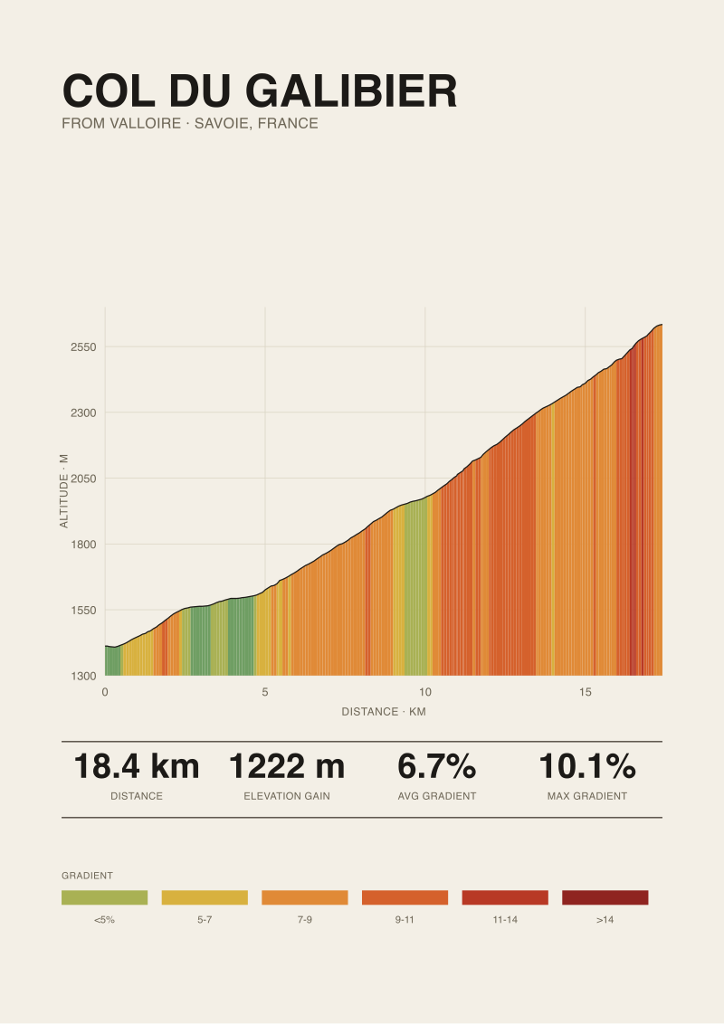
Our reading of the Valloire ascent came out at 18.37 kilometres from Valloire church square to the pass at 2,634 metres, with 1,222 metres of vertical gain from a start elevation of 1,412. Average gradient, computed the honest way as total gain over total length, is 6.7 percent. That figure is the arithmetic mean of the ascent taken as one continuous slope. It flattens the tunnel-avoidance loop near the top, it flattens the false valleys at Plan Lachat, and it flattens everything about how the climb actually feels to ride. But as a comparable number against other satellite-derived measurements, it is defensible.
The 10.1 percent maximum we cite is not a satellite figure. It is published by climbfinder.com for the Valloire ascent and we carry their source. That distinction matters. Maximum gradients derived from 30-metre elevation grids tend to be lower than what a rider experiences because the grid smooths over short-range spikes. Sources that publish higher maxima usually do so from road-book measurements, and we mark that difference in provenance rather than blend it into a single number.
 Col du Galibier
The print from this article · from €29.95
View the print →
Col du Galibier
The print from this article · from €29.95
View the print →
August 2024: The Published Figures, Sorted and Ranked
We are not going to reprint the twelve figures in a table. Doing so would spread twelve versions of a number instead of one, and that is precisely the mechanism this article exists to argue against. What we can describe is the shape of the disagreement.
The lengths clustered in three loose groups. One group hovered near our satellite figure, which is what happens when a source has quietly used the same underlying data we did and rounded it. A second group sat noticeably shorter, and traced back to figures that appear to have been measured from a slightly further-up starting point, either the edge of Valloire proper or one of the ski-village car parks north of the church. A third group ran longer, and those figures tended to include the descent kilometre from the pass to the Col du Lautaret junction, which is a different segment of road and should not be in the number.
Elevation gain showed a smaller spread but the same structural cause. Sources that started higher gained less. Sources that quoted 2,645 or 2,646 metres for the summit were measuring to the observatory marker above the pass rather than the road surface at the pass itself. The road tops out at 2,634 by our measurement, which is where a rider clips out. Neither figure is wrong, but they are not the same measurement, and treating them as interchangeable is where errors compound.
Average gradient is the number we found the least useful in aggregate. Everyone divided their length into their gain and got a percentage. The percentages agreed roughly at the second decimal and disagreed on everything that actually decides whether a section of road hurts.
September 2024: Counting Hairpins Instead of Kilometres
The hairpin count is the part of the audit that stopped being about measurement and started being about definition. Two sources gave a single figure for the entire Valloire ascent. Two others split their count between the lower half up to Plan Lachat and the upper half above it. Three did not attempt a count at all. The remaining five gave numbers, and no two of the five agreed.
What is a hairpin on the Galibier? The road above Plan Lachat is a sequence of open switchbacks whose angle depends on where you decide the turn begins and ends. A geographer with a satellite view and a rule that a switchback must exceed 150 degrees of direction change will count one number. A rider using the more intuitive definition of "a corner tight enough that you have to sit up and unweight the inside pedal" will count another. A road-book editor working from a paper map from the 1970s will count a third. The lower approach out of Valloire, where the road climbs through the pines and up past the ski infrastructure, is contested by the same rules. A few of the tighter bends near the top of the resort read as switchbacks on the map and as fast sweepers in the saddle.
We did not publish our own hairpin count. Not because we cannot, but because the exercise made clear that any single number would join the pile of contested figures without settling anything. The right output of a hairpin audit is not a corrected count. It is a map with every turn drawn, and a note beside each one saying what angle it makes. That is a print, not a paragraph.
October 2024: Where the 10.1 Percent Number Comes From
The 10.1 percent maximum gradient we cite for the Valloire side is the figure climbfinder.com publishes in its Valloire road-book for the Galibier. We carry the source in our own metadata because a maximum gradient without a source is worth roughly what an unattributed quote is worth in a courtroom, which is nothing.
Two things about that figure are worth stating plainly. First, 10.1 percent is a road-book figure, not a satellite figure. Road-book measurements pick up short ramps that a 30-metre elevation grid averages away. If you plot the same ascent purely from SRTM data and take the steepest hundred-metre segment, you will find a number below 10 and, depending on how the segment is cut, sometimes noticeably below. Both figures describe real properties of the same road, but they are not measuring the same thing. Treating them as interchangeable is how a climb ends up with three "maximum gradients" in circulation, all correct in their own frame and all wrong when quoted in the other's.
Second, the maximum matters less than most sources imply. The Galibier from Valloire is a long climb with a tough section above Plan Lachat that runs sustained rather than spiky. A rider who plans a pacing strategy around a single 10.1 percent number will misread the climb entirely. The ramps above Plan Lachat are what wear you down. The wall at the tunnel bypass is what breaks you. Neither of those is captured by a maximum gradient reported to one decimal place. If you want a print of the Galibier that tells you something honest about how it will ride, the profile is the number. The rest are footnotes.
What It All Means
Twelve sources for the length of one climb is not, in the end, twelve arguments about the length of that climb. It is twelve different measurement conventions, twelve different starting points, and twelve different assumptions about what counts as the same road. The disagreements are almost never about accuracy. They are about definition, and definitions do not resolve by taking an average.
What that changes for a rider planning a trip is smaller than it sounds. The Galibier from Valloire is a climb of a shade under 18.5 kilometres for around 1,220 metres of gain at just under seven percent, with a hard section in the upper third and a maximum ramp somewhere near 10 percent depending on how the source measured it. Any figure a reasonable source publishes will fall inside those brackets. Choosing which decimal to trust is a hobby, not a decision.
What it changes for anyone drawing the climb is larger. A print that quotes a single figure without saying where it came from is a print that has taken a position without doing the work. We measure our climbs from a documented elevation model, we carry the source of any published figure we cross-reference, and when a number is genuinely contested — as the hairpin count of the Galibier is — we would rather draw the geometry than pretend the count is settled. If a rider wants a Galibier they can hang on the wall and read like a map of what they actually rode, that is the one available in our shop. If a rider wants an argument about the length, this article is the argument. The two things are not the same.
FAQ
How long is the Col du Galibier from Valloire, precisely?
Measured from Valloire church square to the pass at 2,634 metres, using OpenTopoData's SRTM 30-metre satellite elevation model, the ascent is 18.37 kilometres for 1,222 metres of vertical gain. Published sources give figures both shorter and longer than that, depending on where they set the starting point and whether they include the road beyond the summit. Any figure between roughly 18 and 19 kilometres from a reasonable source is describing the same climb, measured differently.
What is the maximum gradient of the Valloire side?
The figure we carry is 10.1 percent, published by climbfinder.com in its Valloire road-book. That is a road-book measurement, meaning it picks up short ramps that a 30-metre satellite grid averages out. A gradient computed purely from SRTM data on the same road will come in lower for the same steepest segment. Both are describing real properties of the asphalt. They are not the same measurement, and quoting one as the other is the source of most contested maxima.
Why does the average gradient of 6.7 percent feel wrong on the road?
Because it is an arithmetic average of the whole ascent, and the Galibier is not evenly graded. The 18.37 kilometres include the flat run through Valloire, the false valleys at Plan Lachat, and the ramps above them. A single 6.7 percent number treats a shallow kilometre and a nine-percent kilometre as equivalent inputs. On the road they are not. Reading the profile section by section is the only way to see what the average is hiding.
How many hairpins are on the Valloire ascent?
There is no single defensible number. The count depends on what angle you require a turn to make before you call it a hairpin, and on whether you count sweepers through the resort as corners at all. Sources we reviewed gave counts ranging widely, and no two of the ones that gave a specific figure agreed on it. Drawing the geometry of the climb is more honest than picking a number. We chose not to publish one.
Is the ascent from the Col du Lautaret the same climb?
No. The southern ascent from Lautaret is a different climb with different length, different gain, and a different character. Sources that quote a length for "the Galibier" without specifying the side are describing one of two distinct routes, and the confusion between them accounts for a meaningful share of contradictions in published figures. If the source does not say Valloire or Lautaret, the figure is ambiguous by default.
Where does the road actually top out?
The road surface at the pass sits at 2,634 metres by our SRTM measurement. Some sources quote 2,645 or 2,646 metres, which corresponds to the observatory marker above the pass rather than the road itself. Both are real elevations on the same mountain. The one a rider clips out at is 2,634. Which figure a source uses tells you what they were measuring, which is more useful than treating either as a corrected version of the other.
Why not just publish a table of the twelve sources and their figures?
Because reprinting a wrong figure with attribution still spreads it. This piece is about the method that causes the disagreements, not a leaderboard of who is closest to our number. Our number is defensible for what it measures. Other sources are defensible for what they measure. A table would suggest the exercise is competitive, and the exercise is not competitive. It is about naming what is being counted before counting it.
Which figure should I use for planning a ride?
Any reasonable published figure for the Valloire ascent will describe the same climb closely enough for planning. The climb is a shade under 18.5 kilometres, around 1,220 metres of gain, average near seven percent, with a hard section in the upper third. Choosing a source to two decimal places will not change how you pace it. Reading the profile — where the ramps are, where the false flats are, where the wall near the top sits — will.
From the collection



New climbs and 10% off your first print.
One email now with your code. No noise after.