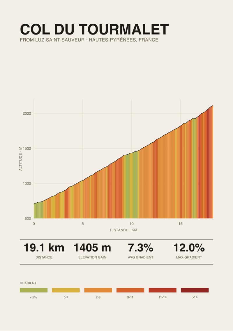
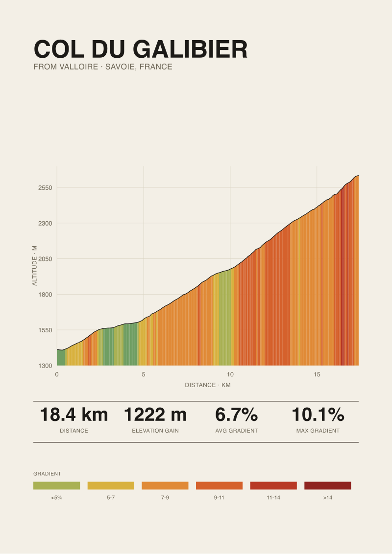
1,405 metres against 1,222 metres of vertical gain. 19.12 kilometres at 7.3 percent against 18.37 kilometres at 6.7 percent. Those four numbers, drawn from OpenTopoData SRTM 30m samples of the Luz-Saint-Sauveur ramp of the Tourmalet and the Valloire ramp of the Galibier, are what customers ask us to translate into ink. They rarely ask which climb to buy. That is the wrong question. The right one is what the print is doing on the wall, and for whom. We answer it below through three composite readers we have sketched often enough to recognise on sight, each walking the same two profiles toward a different frame.
Before the scenarios, one honest limit. Every number below about the shape of the road comes from SRTM 30m elevation samples of the two named ascents. Where we mention a maximum gradient, we use the published road-book figure and name the source: 12.0 percent for the Tourmalet from Luz-Saint-Sauveur and 10.1 percent for the Galibier from Valloire, both catalogued by climbfinder.com. We keep the two apart because a satellite-measured average and a road-book peak are different animals; a print that pretends otherwise is decoration, not data.
Scenario 1: The Rider Who Actually Turned the Cranks on One of Them
Picture a rider in their late thirties who booked a week in Luz-Saint-Sauveur two summers ago and rode up the Tourmalet on a Tuesday morning. They remember the mairie, the D918 sign, the shaded first six kilometres, and the moment the trees give up somewhere above La Mongie. They did not ride the Galibier. They know the name; they have watched it on television for twenty years; they have never turned a crank on it. This is the most common buyer we see, and the print they choose is almost never the one they intellectually admire.
The math they are living inside, whether they say it out loud or not, looks like this. Their Tourmalet ascent started at 709 metres of elevation and finished at 2,114 metres. The road covered 19.12 kilometres. Their body climbed 1,405 metres of vertical, averaging 7.3 percent, with the road-book peaking at 12.0 percent on ramps they remember as specific corners. If they trained at 3.5 watts per kilogram and weighed 72 kilos, their Tourmalet was roughly an hour and forty minutes of continuous effort above threshold; if they weighed 82 kilos and trained at 2.8, it was closer to two hours and fifteen. Either way, the profile on the wall is a diary entry.
Compare that to what the Galibier would ask of them on paper. From Valloire, the ascent is 18.37 kilometres — 750 metres shorter than their Tourmalet — at 6.7 percent average with a 10.1 percent published maximum. It gains 1,222 metres, or 183 metres less than what they already did. The road ends at 2,634 metres, a full 520 metres higher than the Tourmalet summit they stood on. On the wall next to their bed, the Galibier print would be a taller mountain they cannot yet claim.
We sell this rider the Tourmalet print roughly nine times out of ten, and we do not try to talk them out of it. A profile you have ridden is not a comparison problem; it is a receipt. The Galibier's higher summit and its Alpine altitude are irrelevant to what the print is doing above their desk. What matters is that the 19.12-kilometre line traces a road their legs remember at a resolution the eye cannot fake. We frame the print with the ascent name spelled out — from Luz-Saint-Sauveur, not the ambiguous "Col du Tourmalet" that could mean either side — because specificity is the whole product.
Scenario 2: The Armchair Historian Who Watches Every July
Now imagine a different reader. Sixty-two years old, watches the Tour every summer from a chair, has never ridden either climb and does not intend to. Their relationship with the mountains is textual: books, television commentary, the memory of a stage from 1998 or 2011 that they can date within a week. When they walk into the shop, the question is not "which one did I ride?" It is "which one carries more of what I have loved for forty years?"
For this reader, the arithmetic of difficulty matters less than the arithmetic of altitude and appearance. The Galibier's numbers on our SRTM read of the Valloire side — 18.37 kilometres, 6.7 percent, 1,222 metres gained, 2,634 metres at the summit — describe a climb that photographs as a mountain because its top is a mountain. Above 2,000 metres the trees have been gone for a long time; the road at the summit is the highest paved pass in the immediate area. A profile drawn to accurate scale looks like what a non-cyclist expects a mountain to look like. The Tourmalet, ending at 2,114 metres after starting from a Pyrenean village at 709, has 1,405 metres of gain — more brutal on paper — but the profile does not read as tall because the vertical range is compressed by the higher start of the comparison.
Historically, both climbs sit near the top of the Grand Tour rota. The Tourmalet has been crossed by the Tour de France more often than any other high pass, first in 1910 as part of the original Pyrenean circle. The Galibier's first Tour crossing came in 1911 via the Lautaret. For a reader who cares about which climb has held more decisive stages, the honest answer is that both have; the choice is aesthetic. What does the wall want to be looking at every morning?
We sell this reader the Galibier print more often than not, and the reason is measurable. When we render the two profiles at identical horizontal and vertical scale, the Galibier drawn from Valloire terminates 520 metres higher on the y-axis than the Tourmalet from Luz. The eye reads that difference as gravitas even though the road itself is shorter and the gradient average is 0.6 percentage points gentler. A print bought for what you have watched, rather than what you have ridden, is bought with the eye first.
 Col du Tourmalet
The print from this article · from €29.95
View the print →
Col du Tourmalet
The print from this article · from €29.95
View the print →
Scenario 3: The Partner Buying a Gift and Getting the Geography Wrong
The third composite is the buyer we spend the most time with in email. Let us say it is someone shopping for a partner's birthday. The partner rides. The buyer does not. The buyer knows two things: that the Tour is important to their partner and that "there is one with hairpins and one that goes really high." They arrive at the shop assuming the two climbs are interchangeable examples of the same category. They are not.
The Tourmalet from Luz-Saint-Sauveur and the Galibier from Valloire are in different mountain ranges, on different sides of France, requiring different flights, different holidays, different weeks off work. The Tourmalet sits in the Hautes-Pyrénées, closer to Toulouse; the Galibier is in Savoie, closer to Chambéry and Grenoble. A partner who has ridden the Tourmalet has not, by any reasonable inference, also ridden the Galibier; they are two trips, not two mornings of the same trip. Assuming otherwise is the single most common mistake we redirect.
The math the gift-buyer needs is not the profile math but the biography math. Which climb did the partner ride, and from which side? The Tourmalet has two named ascents — from Luz-Saint-Sauveur on the west, from Sainte-Marie-de-Campan on the east. The Galibier has two as well — from Valloire on the north, from Le Monêtier-les-Bains on the south. Our Tourmalet data (19.12 km, 1,405 m, 7.3 percent) describes only the Luz side; the Sainte-Marie side is a different climb with different numbers. Our Galibier data (18.37 km, 1,222 m, 6.7 percent) describes only the Valloire side; the southern approach is longer and its profile is a distinct drawing.
We ask this buyer three questions before recommending anything: which climb, which side, and did they ride to the summit or turn around. The answers dictate the print. Where they cannot answer, we sell the Tourmalet from Luz — the most-ridden ascent in our catalogue — with a paper card explaining the difference between the two sides, so the partner can correct us if we guessed wrong. Getting the geography right is the whole difference between a gift and a decoration.
The Two Profiles, Read Side by Side
Placed next to each other at the same scale, the two prints tell a specific story about the difference between Pyrenean and Alpine climbing. The Tourmalet from Luz gains more (1,405 m against 1,222 m), climbs steeper on average (7.3 percent against 6.7 percent), and does its work in a slightly longer road (19.12 km against 18.37 km). Its published maximum, 12.0 percent, is nearly two points steeper than the Galibier's 10.1 percent. In pure work terms, the Tourmalet is the harder line.
The Galibier's compensating dimension is altitude. Its summit at 2,634 metres is 520 metres higher than the Tourmalet's 2,114, and its start at Valloire is already at 1,412 metres — higher than most European climbs finish. That means the Galibier print reads as a mountain in the sky, whereas the Tourmalet print reads as a mountain from the ground. Neither is more real. They are answering different questions.
 Col du Galibier
The print from this article · from €29.95
View the print →
Col du Galibier
The print from this article · from €29.95
View the print →
What All Three Buyers Are Really Choosing
Look across the three scenarios and the pattern is not about the mountains. It is about what a profile print does in a room. The rider buys a receipt for an effort their body still remembers, and the receipt is authenticated by the exact ascent name and the exact numbers. The armchair historian buys a portrait of a landscape they have loved through a screen, and the portrait is authenticated by altitude read as gravitas. The gift buyer buys a proxy for their partner's biography, and the proxy is authenticated by getting the side of the mountain correct.
In each case, the choice between the Galibier and the Tourmalet is a choice between two accurate translations of two different roads. The 19.12 kilometres at 7.3 percent and the 18.37 kilometres at 6.7 percent are not competing for the title of "harder"; they are competing for the title of "yours." The word "better" does not enter the arithmetic. Neither climb wins on a metric that matters to a wall.
The other shared pattern is smaller and more practical. All three buyers benefit from the ascent name being spelled out on the print — from Luz-Saint-Sauveur, from Valloire — because both climbs have two sides and the profiles are not interchangeable. The road-book maximum figures also earn their place on the caption because they resolve arguments the average gradient cannot. A print that gives you 7.3 percent average and 12.0 percent published max, sourced, is telling you the truth in two dimensions.
Which Scenario Is You
If you have ridden one of them and not the other, you are buyer one. The print you want is the one you have ridden, in the exact ascent you rode it, and the geometry of the other climb is a conversation for another year. If you have never ridden either but have watched forty years of racing, you are buyer two. The print you want is probably the Galibier for its altitude, or possibly the Tourmalet if a specific stage — 1910, or a favourite modern edition — anchors it in your memory. If you are shopping for someone else, you are buyer three, and the answer is not on our end of the email; it is a phone call to a friend who can confirm which climb, which side, and whether the summit was reached.
Where none of these three describe you cleanly, the honest recommendation is to hold off. A profile print acquires its value from being a specific answer to a specific question. If the question is fuzzy, so is the answer, and the wall notices.
Where the Prints Live in the Shop
Both the Tourmalet from Luz-Saint-Sauveur and the Galibier from Valloire are drawn from the SRTM samples described above and available at see the Col du Tourmalet print, each captioned with the numbers we have used in this article: length, gain, average, published maximum with source. The captions are part of the print, not a sticker on the back, because a profile without its scale is a squiggle.
FAQ
Is the Galibier a harder climb than the Tourmalet?
On the ascents we measured, no. The Tourmalet from Luz-Saint-Sauveur gains 1,405 metres over 19.12 kilometres at 7.3 percent average, with a published maximum of 12.0 percent per climbfinder.com. The Galibier from Valloire gains 1,222 metres over 18.37 kilometres at 6.7 percent, published maximum 10.1 percent. The Tourmalet is longer, steeper on average, and gains 183 more metres. What the Galibier has instead is altitude: its summit at 2,634 metres sits 520 metres higher than the Tourmalet's 2,114.
Which climb prints better on paper?
Both print well because their profiles are legible at a glance, but they read differently on a wall. The Tourmalet from Luz-Saint-Sauveur starts at 709 metres and climbs a long, roughly consistent ramp — the print reads as a mountain rising from a valley. The Galibier from Valloire starts at 1,412 metres and finishes at 2,634, so at identical scale its line sits higher on the frame. The Tourmalet looks taller in vertical range; the Galibier looks higher in absolute altitude.
Do these numbers apply to both sides of each climb?
No. Our Tourmalet numbers describe the Luz-Saint-Sauveur ascent from the west, not the Sainte-Marie-de-Campan ascent from the east. Our Galibier numbers describe the Valloire ascent from the north, not the Le Monêtier-les-Bains ascent from the south. Each climb has two distinct profiles depending on the side. If a rider you know has climbed either summit, ask which side before assuming any of these figures describe their day.
Where do the elevation figures come from?
Length, gain, start elevation, summit elevation, and average gradient come from OpenTopoData samples of SRTM 30-metre elevation data along the road for each named ascent. The maximum gradient figures — 12.0 percent for the Tourmalet from Luz, 10.1 percent for the Galibier from Valloire — come from climbfinder.com's road-book listings. We keep the two sources distinct because satellite-derived averages and road-book maxima are measured differently, and a print that blurs the two is less useful than one that names each.
Why do the average gradients look so close when the climbs feel different?
Because average gradient is one number describing a road that is not one thing. The Tourmalet's 7.3 percent and the Galibier's 6.7 percent hide the shape of the ramps: where the flatter kilometres are, where the ramps at or near the published maximum sit, whether the hard sections come early or late. This is precisely why we draw the profile rather than list a single figure. A print shows you the road; an average is a rumour about it.
Is there a print that shows both climbs together?
Not in our current catalogue. We render climbs individually because a comparison print forces both profiles onto a shared axis, and either the taller one dominates the frame or the steeper one loses its vertical detail. If a buyer wants both, we recommend two separate prints hung as a pair, drawn at identical scale so the eye can compare fairly. The 520-metre summit difference and the 183-metre gain difference become readable rather than hidden.
What if I want a climb I have actually ridden but it is neither of these?
We measure and draw many European climbs beyond these two — the Alps, the Pyrenees, the Dolomites, and the Spanish and Mallorcan ranges. The method is the same: SRTM samples along the named ascent, road-book maxima cited by source, ascent side spelled out on the caption. If a specific climb you rode is not in the shop, it may still be in our measured backlog; ask and we will tell you honestly whether it is drawn, queued, or not something we cover.
From the collection



New climbs and 10% off your first print.
One email now with your code. No noise after.