Mont Ventoux from Bédoin is 21.51 kilometres long. It climbs 1,575 metres. Its average gradient is 7.3 percent. Those are measurements — pulled from OpenTopoData's SRTM 30-metre grid, calculated against a profile in our archive. Alpe d'Huez, by contrast, has 21 hairpins. That is the number the postcards print, the number television commentary reaches for, the number readers ask us about. It is a hairpin count. It is not a climb specification. And the gap between what the mountain is and what the marketing measures is the whole story of how road cycling's most famous ascent gets described.
What the Numbers Actually Say
The 21 refers to switchbacks numbered in descending order from Bourg-d'Oisans, painted on the road, celebrated on jerseys. It is a count of turns. Turns do not tell you how far you climb, how high you finish, or how steep the road tilts between them. A tight spiral staircase has more turns than any Alp; nobody would call it a climb.
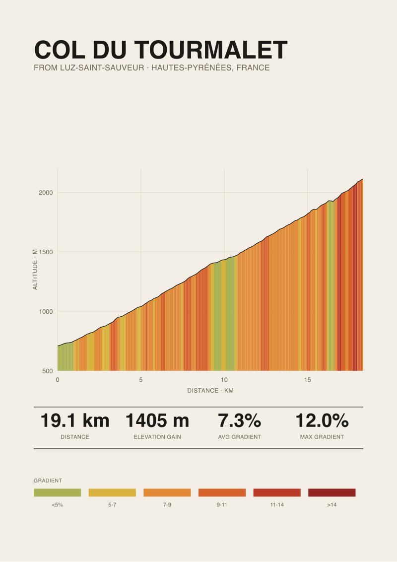
Compare what a climb specification actually contains. Mont Ventoux from Bédoin: 21.51 km, 1,575 m of gain, 7.3 percent average. Passo dello Stelvio from Prato allo Stelvio: 25.04 km, 1,840 m, 7.3 percent. Col du Tourmalet from Luz-Saint-Sauveur: 19.12 km, 1,405 m, 7.3 percent. Passo di Gavia from Ponte di Legno: 18.42 km, 1,366 m, 7.4 percent.
Four climbs, four averages within a tenth of a point of each other, four different rides. Stelvio is nearly seven kilometres longer than Gavia. Ventoux climbs 209 metres more than Tourmalet. Gavia and Tourmalet finish at radically different altitudes — 2,610 metres versus 2,114 metres. All of that variation is invisible if you compress the description to a single number.
Now put "21 hairpins" next to any of those three-part specifications and notice what happens. The specification tells you what to expect: how many hours, how much altitude, how the effort accumulates. The hairpin count tells you what the road looks like from a helicopter.
This matters because riders make decisions from the number they hear. Somebody who reads "Ventoux, 21.51 km at 7.3 percent" is being told, correctly, to plan for roughly an hour and a half to two hours of steady climbing depending on pace, with no meaningful respite from the gradient. Somebody who reads "Alpe d'Huez, 21 hairpins" is being told a piece of cinematography, not a piece of information. The postcard was designed to sell postcards. It succeeded. It did not do the reader any favours.
What Nobody Mentions
Our climb specifications come from a specific source: elevation grids from OpenTopoData's 30-metre SRTM sampling, calculated against the exact ascent line in our archive. That is a satellite-derived measurement — you can pull it, reproduce it, argue with it. It is the same reason we can state Stelvio's 25.04 km rather than rounding to "about 24" or "about 26" depending on which travel guide we read.
The maximum gradients in our records come from a different source. For Stelvio the published maximum is 14 percent; for Ventoux and Tourmalet, 12 percent; for Gavia from Ponte di Legno, 16 percent. All four are drawn from climbfinder.com's road-book compilations. These are the numbers the paving surveys and road books cite. They are not directly comparable to a satellite average — satellite grids sample every 30 metres and smooth what happens between; road books record what a wheel actually feels on a specific ramp.
The result is a two-source structure that nobody mentions in the marketing. Ventoux averages 7.3 percent measured, tops out at 12 percent published. Gavia averages 7.4 percent measured, tops out at 16 percent published. On paper, Ventoux and Gavia sit a hair apart. In the legs, one road tilts to twelve and the other bucks to sixteen. Those are different climbs pretending to be the same category.
"21 hairpins" hides this entire distinction. The hairpin count is a piece of geometry; the gradient story is a piece of engineering. A well-graded switchback pattern was designed precisely to keep the roadbed within a manageable slope — that is what switchbacks are for. The count of them is inversely related to how brutal the road felt to build, not to how brutal it feels to ride. A road with more hairpins is usually a road with a more merciful average. The postcard number is celebrating the mercy while implying the difficulty.
We flag this every time we render a print of a climb whose published maximum diverges from its measured average. It is not a caveat readers ignore. It is often the reason they buy the specific profile in the first place: they want to see where the road actually turns brutal, not where the tourist board says it does.
 Mont Ventoux
The print from this article · from €29.95
View the print →
Mont Ventoux
The print from this article · from €29.95
View the print →
The Real Cost
Work out what a rider actually needs to plan a day, and the hairpin count fails on every axis.
Altitude, first. Stelvio finishes at 2,748 metres. Gavia finishes at 2,610 metres. Tourmalet finishes at 2,114 metres. Ventoux, from Bédoin, finishes at 1,892 metres. That range — 856 metres between highest and lowest — is enough to change what a rider brings, what they wear, and what their lungs do in the final third. Nobody rides Stelvio's last five kilometres the way they ride Ventoux's, because Stelvio's last five kilometres are above 2,500 metres. Number of hairpins: irrelevant.
Starting altitude, second. Gavia begins at 1,244 metres above sea level. Ventoux begins at 317 metres. That is a 927-metre difference in where the effort starts. A rider standing at Ponte di Legno is already above the summit of every Belgian climb; a rider standing at Bédoin has the entire Provençal plain under their wheels before the road tilts. The Gavia rider will be cold in the neutral zone. The Ventoux rider will overheat before the forest. Nobody plans clothing from a hairpin count.
Duration and shape, third. Stelvio at 25.04 km is a two-hour effort for most trained amateurs — call it an hour forty for very strong riders, over two for the rest. Tourmalet at 19.12 km with 435 fewer metres of gain shaves that considerably. Gavia at 18.42 km looks similar to Tourmalet on paper, then reveals a published maximum of 16 percent that Tourmalet does not have. Duration and shape are not encoded anywhere in the count of switchbacks.
Pacing, fourth. Ventoux's 12 percent published maximum lives in the forest section, roughly the middle third of the climb. Gavia's 16 percent lives in specific ramps that riders learn to name. The pacing plan for a climb whose worst gradient is front-loaded is not the pacing plan for a climb whose worst gradient is at the top. The hairpin count is silent on this. It is silent on everything a rider would need to know to prepare.
The real cost of the 21-hairpins framing is not that it is wrong. It is that it displaces the numbers that would help. A reader who leaves an Alpe d'Huez article knowing only "21 hairpins" has been given a souvenir, not a briefing. The souvenir is charming. The briefing is what the climb deserves.
If You Only Remember One Thing
Ventoux and Tourmalet average the same gradient — 7.3 percent on both — over lengths that differ by 2.39 km and gains that differ by 170 metres. Two climbs, one shared average, meaningfully different days out. Any framing that reduces a mountain to a single number is discarding the numbers that let a rider tell those two climbs apart.
7.3 percent is a specification. It compresses length and gain into a rate. Twenty-one hairpins is a decoration. It compresses nothing; it just counts. The number that should decide whether you actually understand a climb before you ride it is the average gradient across its measured length. That is the number Alpe d'Huez's marketing has spent decades not telling you. The 21 is the answer to the wrong question.
If you want any of the four climbs above rendered as a data print — the profile itself, drawn from the same elevation grid these numbers come from — we sell them at see the Mont Ventoux print.
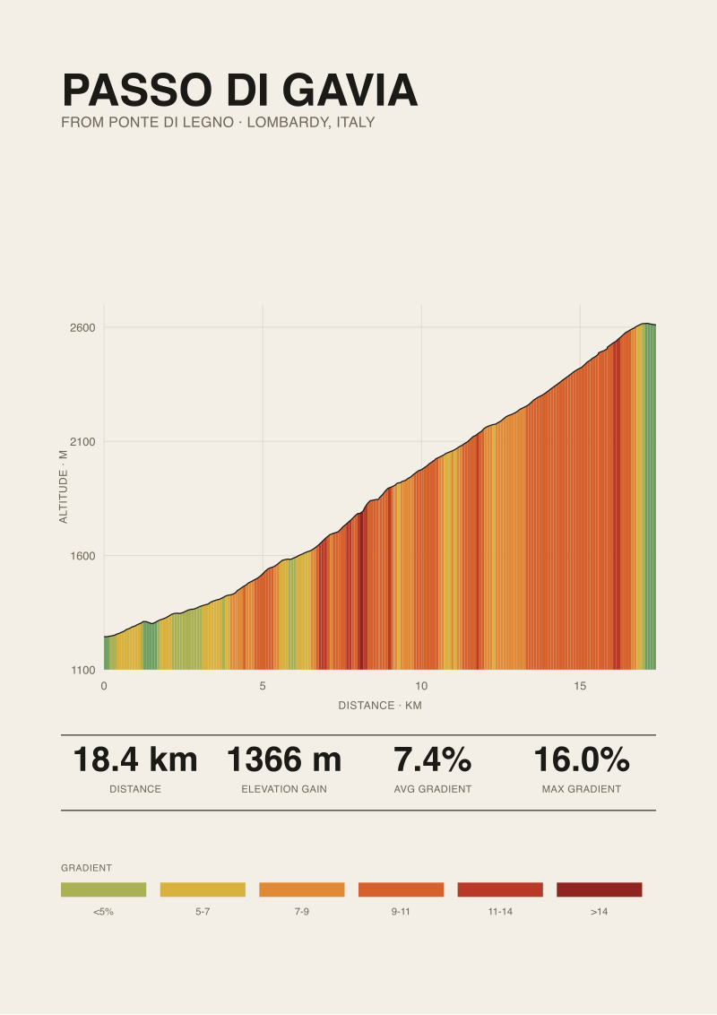 Passo di Gavia
The print from this article · from €29.95
View the print →
Passo di Gavia
The print from this article · from €29.95
View the print →
FAQ
Why does the Climb Prints desk cite length and gradient but not maximum gradient for Alpe d'Huez?
Length, gain, and average gradient come from a reproducible satellite grid — OpenTopoData's SRTM 30-metre sampling calculated along the exact ascent line. Maximum gradient is different: it depends on a road-book source measuring a specific ramp at ground level. When our archive does not yet hold both sources for a given climb, we prefer to name what is unknown rather than paste in a number we cannot stand behind.
Which of the four climbs cited in this piece finishes at the highest altitude?
Passo dello Stelvio from Prato allo Stelvio, at 2,748 metres. Passo di Gavia from Ponte di Legno tops out 138 metres lower at 2,610. Col du Tourmalet from Luz-Saint-Sauveur finishes at 2,114 metres, and Mont Ventoux from Bédoin at 1,892. The 856-metre span between highest and lowest summits changes what riders wear, what they carry, and how their lungs behave in the final kilometres.
Are climbs with the same average gradient effectively the same difficulty?
No, and the four climbs cited here are the cleanest possible demonstration. Ventoux, Stelvio, and Tourmalet all average 7.3 percent; Gavia averages 7.4. Yet Stelvio at 25.04 km climbs 1,840 metres, while Tourmalet at 19.12 km climbs 1,405. Same rate of ascent, wildly different totals. Average gradient tells you the slope; length and total gain tell you the day.
Why does the published maximum for the Gavia reach 16 percent when the average is only 7.4?
Because averages and maxima measure different things. The 7.4 percent average is the total gain (1,366 m) divided over the total length (18.42 km) — a rate. The 16 percent published maximum, drawn from climbfinder's road-book data for the Ponte di Legno ascent, records the steepest ramp on that road. A climb with a modest average can still host a very steep short section, and the Gavia is the classic example.
Which climb in the desk's records has the lowest starting elevation?
Mont Ventoux from Bédoin, at 317 metres above sea level. That is nearly a kilometre lower than the start of Passo di Gavia from Ponte di Legno (1,244 m). A low start means a long approach through valley temperatures before the road tilts — a factor riders often underestimate on Ventoux specifically, where the transition into the forest section arrives with legs already warm.
Does a higher hairpin count mean a harder climb?
Usually the opposite. Switchbacks exist to keep a roadbed within a slope that vehicles can climb without cog railways. A road that needed many switchbacks was steep terrain that had to be tamed; the switchbacks are the taming. So a headline hairpin count is often a marker of the engineering that made the road ridable, not a marker of how brutal the finished gradient feels. Count them for the photograph, not for the plan.
What elevation data source does Climb Prints use, and why does it matter?
We use OpenTopoData's SRTM 30-metre grid — a public satellite elevation dataset sampled every 30 metres. It matters because it is reproducible: any reader can pull the same grid, run the same profile against the same ascent line, and check our numbers. It is why our specifications sit as 25.04 km rather than "about 25", and why the profile on any print we sell can be traced back to a specific dataset rather than a marketing rounding.
From the collection


New climbs and 10% off your first print.
One email now with your code. No noise after.