Alpe d'Huez is the more famous climb, and it is also the less interesting one to put on a wall. Hear us out. From Bourg-d'Oisans the road covers 15.97 km and gains 1,048 m at an average of 6.6 percent, with a published maximum of 13 percent. From La Vega, the Angliru covers 13.22 km and gains 1,247 m at 9.4 percent average, with a published maximum of 23.5 percent at Cueña les Cabres. Two climbs, two shapes, one wall. The cycling internet keeps telling you the choice is about difficulty. It is not.
Fame and shape are different variables. A print is a shape hung on a wall. Whatever the algorithm and the merchandising world have taught you to want, the honest question is which of these two profiles is the more interesting drawing when the road is stripped down to its elevation.
We measure climbs before we draw them, which means we have both roads in front of us as line art rather than as legend. Seen that way, the received wisdom about these two mountains starts to look strange. Alpe d'Huez is treated as the archetype and the Angliru as its more brutal younger cousin. That framing is wrong twice. It is wrong about Alpe d'Huez, which is the more measured of the two roads, and it is wrong about the Angliru, which is not a harder version of anything. Two shapes. Two arguments. One decision.
The Bourg-d'Oisans Consensus Is Wrong, and the Profiles Prove It
Pick any of the popular climb-comparison pieces from the last ten years and you will find the same paragraph about Alpe d'Huez. Twenty-one hairpins. Fourteen kilometres. Tour de France legend since 1952. A gradient described as "punishing" or "relentless" or, in the more excitable places, "brutal". The number attached to that adjective is almost always the average, 8.1 percent, which is the figure printed on the road signs and repeated in every guidebook.
Our measured profile from Bourg-d'Oisans gives a different number: 15.97 km, 1,048 m of gain, and an average of 6.6 percent. That is not a small discrepancy. It is the gap between a climb the tourist boards can sell as one of the hardest roads in cycling and the climb the elevation data actually shows, which is a long, well-graded alpine ascent that would be considered a strong but unremarkable HC in the Pyrenees if it did not have the Tour behind it.
The difference is not fraud. The 8.1 percent figure is calculated from the first hairpin, which is where the road turns properly upward and where the signage starts counting. Our measurement starts in Bourg-d'Oisans itself, at 773 m, and includes the approach to that first ramp. Both numbers are honest. They just answer different questions. The one everyone quotes answers the question "how steep is the interesting part of the climb". The one on our print answers the question "what shape does the road actually draw between the valley floor and the ski station at 1,820 m".
Once you look at the profile as a shape rather than as a slogan, the character of Alpe d'Huez becomes clear. The steepest section is at the bottom. The road settles into something close to a straight diagonal for most of its length. The hairpins are numbered down from 21 to 1, and the gradient hovers between 7 and 9 percent through most of them, with a published maximum of 13 percent that shows up briefly and is not where the climb is decided. It is a fair road. It rewards a rider who can sit at threshold for around forty minutes and does not punish anyone for a bad opening kilometre because there is a lot of road left to fix a mistake.
That is the correct description of Alpe d'Huez, and it is also why the print of Alpe d'Huez, drawn from the measured data, is a beautiful but relatively quiet object. A gently rising diagonal from 773 m to 1,820 m with a small kick at the base and a shallow flare at the top. If your visual imagination of it involves jagged spikes and wild vertical drama, that imagination was built by television camera angles and by the compressed profile diagrams the Tour organisation prints in the roadbook, both of which distort the vertical axis to make the road look more violent than it is. The line, drawn to true proportion from SRTM elevation data, is calmer than the reputation.
The consensus that Alpe d'Huez is the definitive test of a climber is a marketing artefact. It is the definitive test of a rider who can hold high sustained power for forty to fifty minutes in the shape of a road that mostly does one thing. That is a real test. It is not the only test, and once you draw the two profiles side by side, it is very clearly not the more visually interesting of the two shapes on offer here.
Angliru Is Not a Harder Alpe d'Huez, It Is a Different Object Entirely
The Angliru is usually introduced with a comparison. It is described as "steeper than Alpe d'Huez", or "the Spanish Alpe d'Huez", or, in the most confused version, "what Alpe d'Huez would be if it were harder". Every one of those framings misreads what the climb is. The Angliru is not a version of anything. It is a different category of object.
Start with the measured numbers. From La Vega, the road is 13.22 km long. It gains 1,247 m. Its average gradient is 9.4 percent. Its published maximum, at Cueña les Cabres, is 23.5 percent, sourced from Vuelta documentation and from climbfinder's road data. Compare those to Alpe d'Huez: the Angliru is roughly 2.75 km shorter, gains 199 m more, averages 2.8 percentage points steeper, and reaches a maximum gradient that is 10.5 percentage points higher. Those are not tuning differences. Those are the numbers of a different genre of road.
The clearest way to see what that means is to look at the shape rather than the summary statistics. Alpe d'Huez draws a line. The Angliru draws a staircase with a landing. The first six kilometres from La Vega climb at a manageable four to six percent, the kind of gradient a good amateur can process without much drama. Then the road turns and the profile changes character completely. The Cueña les Cabres section, roughly between kilometres nine and eleven, does not sit at 15 percent, it lives there, with ramps at 20 and briefly 23.5 percent that are not spikes on the graph but sustained walls. After it, the road eases toward the summit at 1,560 m as if apologising.
There are two things that follow from this shape, and both matter for the print decision. The first is that the average gradient of 9.4 percent describes almost nothing about how the climb feels or how it looks drawn. An average is the wrong summary for a road with a variance this large. The 6 percent opening and the 20 percent middle both contribute to the same 9.4 percent figure, and if you rode the climb using that number as your mental model you would blow up somewhere around Cueña les Cabres wondering what happened. The published maximum, 23.5 percent, tells you more about the climb than the average does, which is a rare property.
The second is that the profile is unusually photogenic in line-art form. It has three legible acts. Approach. Wall. Recovery. A designer could not have shaped a more legible piece of terrain if the goal were to fit a memorable silhouette into a rectangular frame. The wall in the middle registers instantly as the thing the print is about, and the opening and closing act as visual runway for it. Alpe d'Huez, drawn honestly, is a single-act shape. The Angliru is a three-act shape with a villain in the middle. As drawings, that is not a subtle distinction.
None of this is a statement about which climb is harder to ride, incidentally. Harder is a rider-specific question. A time-triallist with a diesel engine will find Alpe d'Huez the harder of the two because it does not let up. A lighter rider with good short-power capacity will find the Angliru objectively terrifying but survivable, because the walls are short and the road recovers. The question of which climb hurts more depends on the rider. The question of which climb draws a more interesting profile does not. The Angliru wins that comparison decisively, and it wins it because of the shape, not because of the summary numbers.
Which is why calling the Angliru "the Spanish Alpe d'Huez" is not just imprecise, it is category confusion. The two roads solve completely different problems. Alpe d'Huez asks a rider to sustain. The Angliru asks a rider to survive a specific two-kilometre event embedded in a longer climb. Merging them into a single comparison axis, where one is simply a harder version of the other, is the sort of framing that only makes sense if you have not looked at either profile.
 Alpe d'Huez
The print from this article · from €29.95
View the print →
Alpe d'Huez
The print from this article · from €29.95
View the print →
The Print You Hang Is a Statement About What You Think Cycling Is
Here is where the decision stops being about the two climbs and starts being about the person looking at the wall. A print of a road is a small argument about what makes that road worth remembering. Two people can look at the same profile and see different things. The choice between Alpe d'Huez and the Angliru is not a choice between famous and less famous, or fair and unfair, or easy and hard. It is a choice about which of those arguments you want to make in your own room.
Alpe d'Huez as a print is an argument about the sport's continuity. The road has been in the Tour since 1952. Its 21 hairpins have decided general classifications and lost them. The names on the corner signs are half the story of grand tour climbing since the sixties. When you hang the profile, you are hanging a monument to the version of cycling that is measured in decades of race craft, in tactical patience, in the kind of climb where the rider who wins is usually the rider who was going to win from the base. The shape of the line matters less than what the line has hosted. It is the archive climb.
The Angliru as a print is an argument about the sport's rupture. The road was not on any grand tour until 1999. It was invented, essentially, as an answer to a question the Vuelta was asking about how to make a climb decisive rather than performative, and the answer it gave, in the form of Cueña les Cabres, was to build a section of road that ordinary tactical patience cannot survive. When you hang the profile, you are hanging a monument to the version of cycling in which the terrain, not the team, sets the terms. The shape of the line matters enormously because the shape is the argument. It is the ambush climb.
Both are legitimate arguments about what the sport is for. Neither is more correct than the other. But they are not interchangeable, and the framing of "which is the harder print", which is the framing most of the internet lands on when it discusses this pairing, misses what a print of a road actually is. A print is a shape and a claim. The shape is the elevation profile. The claim is what the elevation profile is doing on the wall.
If you already ride, and you have ridden neither, our editorial position is that the Angliru is the more interesting drawing because the shape carries more information about itself. The three-act structure reads instantly from across the room. The wall in the middle is legible without a legend. Someone who has never heard of the road can look at the profile and understand within about two seconds that a specific and unusual thing happens in the middle of it, and can then be told the number, 23.5 percent, and register the number as consistent with what they are looking at. That is a rare property in a piece of terrain. Very few climbs on the WorldTour calendar have profiles that self-explain the way the Angliru's does.
If you have ridden Alpe d'Huez, none of the above applies. The correct print is the one of the road you turned yourself inside out on, because the shape has become tied to a memory of your own weight against gravity on a specific day. That is the version of the argument the profile makes for you personally, and it is the only version that matters. Our shop exists mostly for that case, which is why every profile in it is drawn from measured elevation data at true proportion rather than compressed for drama. The line has to be honest for the memory to be honest.
This started as a piece about which of two famous climbs makes the better print, and it turned into a piece about how badly the standard comparison framing serves either of them. Alpe d'Huez is not a hard road misrepresented as easy, it is a fair road misrepresented as brutal. The Angliru is not a harder Alpe d'Huez, it is a different genre of climb sharing a category label with it for lack of a better one. The next question, once you have picked which shape belongs on your wall, is why the cycling internet keeps flattening every European climb onto a single hardness axis in the first place, and what a category system built around profile shape rather than difficulty ranking would actually look like. That question is where this piece hands off.
FAQ
Which climb is objectively harder to ride, Alpe d'Huez or the Angliru?
Neither is objectively harder because "hard" is a rider-dependent variable. Alpe d'Huez, at 15.97 km and 6.6 percent average from Bourg-d'Oisans, punishes riders who cannot sustain threshold power for forty-plus minutes. The Angliru, at 13.22 km and 9.4 percent average from La Vega with a published maximum of 23.5 percent at Cueña les Cabres, punishes riders who cannot survive short walls above 20 percent. A diesel-engine time-triallist will find Alpe d'Huez the more painful road. A light climber with good short-power capacity will find the Angliru the more terrifying one.
Why does the Alpe d'Huez signage say 8.1 percent when the measured average is 6.6 percent?
Both figures are honest, they just measure different roads. The 8.1 percent number is calculated from the first hairpin, where the tourist signage starts counting and where the road turns sharply upward. Our 6.6 percent figure covers the full 15.97 km from Bourg-d'Oisans at 773 m to the summit at 1,820 m, including the approach ramp to that first corner. If you want to know the gradient of the interesting bit, use 8.1. If you want the shape of the road that gets drawn from valley floor to ski station, use 6.6.
What actually happens at Cueña les Cabres on the Angliru?
Cueña les Cabres is the section of the climb between roughly kilometre nine and kilometre eleven where the gradient reaches its published maximum of 23.5 percent, per Vuelta documentation and climbfinder's road data. It is not a single ramp but a sustained wall, with sections above 15 and 20 percent for hundreds of metres at a time. Riders on the Vuelta are usually in a fully compact 34x32 or 34x34 gear and moving at walking pace through it. It is where the climb is decided.
Are the numbers on your prints from Strava or from official road books?
Neither. We measure elevation from OpenTopoData SRTM 30 m satellite data along the actual road geometry, then draw the profile at true proportion without vertical exaggeration. Where a published road-book figure exists for the maximum gradient — for example the 23.5 percent Vuelta number for Cueña les Cabres or the 13 percent climbfinder figure for Alpe d'Huez — we list it separately and cite the source. Measured average and published maximum are different data types and deserve to be labelled as such.
Why do the Tour de France profile diagrams look so much steeper than your prints?
Because Tour de France roadbook profiles use heavy vertical exaggeration. The horizontal axis is compressed and the vertical axis is stretched, which turns a 6.6 percent average diagonal into what looks like a shark's tooth on the page. It is a stylistic choice, not an error, and it is designed to make the climbs read dramatically at small sizes in a printed roadbook. Prints drawn at true proportion look calmer because they are honest about the actual angle a road climbs at, which is almost always less steep than television or roadbook graphics suggest.
If I have only ridden one of the two, should I hang the one I rode or the one that draws better?
Hang the one you rode. A print of a climb you have physically been up is a memory anchored to a shape, and the shape becomes personally meaningful in a way no analysis of drawing quality can override. The "which draws better as a piece of line art" argument in this piece is only useful when you are choosing between two roads you have no personal history with. If Alpe d'Huez is a place you turned yourself inside out on a specific summer, that is the correct print for your wall regardless of what the Angliru's silhouette does across the room.
Is the Angliru really only in the Vuelta since 1999?
Yes. The climb was first raced in the 1999 Vuelta a España after being scouted specifically as an answer to the question of how to make a stage race decisive on terrain the peloton could not neutralise tactically. That is a very short history compared with Alpe d'Huez, which first appeared in the Tour in 1952. The recency is part of the argument for what kind of print the Angliru is: it is not archive terrain, it is designed terrain, and the profile drawing reflects that intentionality.
What is the elevation range of each climb?
Alpe d'Huez from Bourg-d'Oisans starts at 773 m and finishes at 1,820 m, for 1,048 m of gain across 15.97 km. The Angliru from La Vega starts at 314 m and finishes at 1,560 m, for 1,247 m of gain across 13.22 km. The Angliru gains almost 200 m more over roughly 2.75 km less road, which is the arithmetic behind the steeper average and the reason the profile compresses more vertical into a narrower horizontal frame when drawn to true proportion.
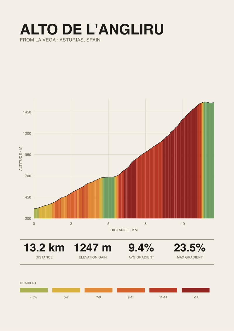 Alto de l'Angliru
The print from this article · from €29.95
View the print →
Alto de l'Angliru
The print from this article · from €29.95
View the print →
From the collection


New climbs and 10% off your first print.
One email now with your code. No noise after.