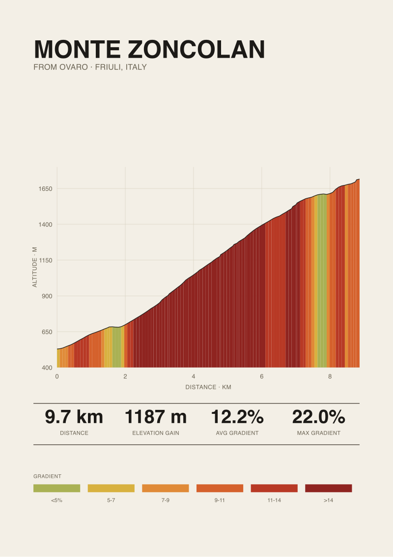
There is a pattern we notice every time we pull a well-known climb into our measurement pipeline: three sources will quote three different lengths, and none of them will explain why. Monte Zoncolan from Ovaro is the current example on our desk. Our SRTM 30-metre elevation trace returns 9.74 km with 1,187 metres of gain, from a 529-metre start to a 1,716-metre summit, averaging 12.2 percent. Published road books round differently, start from different signs, and treat the hairpins as either landmarks or measurement anchors. The 22 percent maximum, cited by climbfinder.com and Giro route documents, is where the disagreements sharpen into something worth counting hairpin by hairpin.
The Length Disagreement Pattern on Famous Climbs
The pattern is not a Zoncolan problem. It repeats on every climb famous enough to have been measured by more than one party, and it always resolves into the same three-way split: a road book, a climbing database, and a race organiser each publish a figure that is close enough to look like agreement and far enough apart to matter. For Monte Zoncolan from Ovaro, we hold three lengths in front of us and a fourth of our own: 9.74 km measured against a 30-metre SRTM digital elevation model. The gap between the numbers is not noise. It is a difference in what each source decided to measure.
The reason road books and databases disagree is that "the climb" is not a physical object with agreed boundaries. It is a decision. Someone chooses a start line — a road sign, a town centre, the last flat metres before the gradient breaks upward — and someone chooses a finish, which is usually less contested because the summit at 1,716 metres is a real place. The start is where the arguments live. On Zoncolan from Ovaro, the plausible start points sit within a few hundred metres of the 529-metre elevation our trace begins at, and every hundred metres of chosen start moves the length by about the same amount and the average gradient by a fraction of a percent.
What makes Zoncolan a useful case is that the disagreement is not hidden. Riders who have done the climb twice from Ovaro will tell you the last five kilometres are unambiguous — you are inside the ramps, the tunnels, the exposed section above the treeline — but the first four are a negotiation between a warm-up and a climb. Different sources have made that negotiation differently, and the length figure they publish is a receipt for the choice. We prefer to keep the choice visible: 9.74 km from an elevation trace beginning at 529 metres, ending at 1,716 metres, gaining 1,187.
The Hairpin Counting Problem, and Why It Isn't Trivial
The hairpin question sounds like it should be easier than the length question. A hairpin is a hairpin: the road doubles back on itself, the switch is legible from a satellite image, you count the U-turns and you write the number down. In practice the count is not stable either, and the reason is the same reason lengths disagree. A hairpin is a decision about what counts as one.
On Zoncolan from Ovaro, the road above roughly the four-kilometre mark stacks switchbacks aggressively, and it is inside that stack that the counting fractures. Some sources count every visible turn where the road reverses direction, including the tight bends inside the exposed upper ramps. Others count only the numbered hairpins — the ones the road authority has signed as tornante N with a plate — which is a smaller number because not every reversal earns a plate. A third convention counts only hairpins that sit inside a gradient regime above a threshold, say 10 or 12 percent, on the argument that gentler turns are just curves in a road that happens to be climbing. Three conventions, three counts, all defensible.
The interesting question is not which count is correct. It is which count carries information. A hairpin count that includes every reversal tells you the geometric complexity of the ascent — how many times you have to stop pedalling straight and start pedalling around a bend, which matters for pacing and for how much time you spend in the inside line where the gradient spikes. A count restricted to signed hairpins is a bookkeeping figure that maps to route furniture, useful for describing landmarks but not for describing effort. A count restricted to the steep-regime turns is closer to a difficulty proxy, because on Zoncolan the inside of an upper hairpin is where the maximum gradient of 22 percent lives, and each of those turns is a small event inside the larger climb.
A hairpin count is not a fact about a mountain; it is a receipt for the counting convention the source chose, and most sources never tell you which one they used.
 Monte Zoncolan
The print from this article · from €29.95
View the print →
Monte Zoncolan
The print from this article · from €29.95
View the print →
The Satellite Profile vs the Road Book Gap
Our 9.74 km comes from an elevation trace built on OpenTopoData SRTM 30-metre data, which means each sample point along the road corresponds to a 30-by-30 metre cell of the Earth's surface with a single elevation value attached. That is a coarse enough grid that the very short, very steep sections — the ones cyclists remember as "the wall" — get smoothed. Our average of 12.2 percent is an honest arithmetic over the full 9.74 km. The 22 percent maximum we cite is not from our own trace; it is the road-book figure published by climbfinder.com and the Giro route documents for the Ovaro side. We name that source explicitly because our profile alone cannot resolve a 22 percent ramp — the sampling grid is not fine enough.
That is the honest limit of a satellite-derived climb profile, and it is the reason road books remain useful. A road book is written by someone driving or riding the road with a wheel measurement and a slope reading, and the maximum gradient they report is a moment on the road, sometimes a moment lasting only 20 or 40 metres. Our trace does not see those moments; it sees the average of the 30-metre cell they sit inside. On a climb like Zoncolan, whose reputation rests on those moments, the road book adds information the satellite cannot.
The other direction of the gap is equally real. Road books tend to round lengths to convenient figures — 10.1 km, 10.5 km, sometimes just 10 km — and they anchor to physical signs on the road, which move over the years and which are chosen by local road authorities for reasons that have nothing to do with climb metrology. The satellite trace does not round and does not care about signs. It gives you 9.74 km because that is what 9.74 km of road passes through in three-dimensional space between the elevations you asked it to measure. Where the two methods disagree, they usually disagree in the direction you would predict from their respective blind spots: road books over-round and drift with signage, satellites under-resolve the peaks.
The practical consequence is that any argument about Monte Zoncolan's length or hairpin count that does not name its measurement basis is an argument about vocabulary rather than about the mountain. Sources that quote 10 km and sources that quote 10.5 km are not necessarily wrong; they are anchored differently. Our 9.74 km is not the correct figure. It is a specific figure with a specific method attached, and the method is the reason we trust it as our own baseline while accepting that a rider paying a road sign will read something else.
What 9.74 km From Ovaro Actually Measures
Nine point seven four kilometres, 529 metres to 1,716 metres, 1,187 metres of gain, averaging 12.2 percent. Those five numbers are what our SRTM 30-metre trace returns for the Ovaro ascent of Monte Zoncolan, and they hang together as a single reading of the road. The average gradient is not a headline figure; it is what falls out of the ratio between gain and length when both are honestly measured. 1,187 divided by 9,740 is 0.1219. That is 12.2 percent to the tenth, and it is why we lead with that number rather than a rounder one.
What the reading measures is the ascending road itself, sampled along its centreline in three dimensions. It does not measure the maximum gradient — we cite 22 percent from climbfinder.com and the Giro route documents because our data cannot resolve it — and it does not measure the total number of hairpins because that count depends on which convention you use. It measures the corridor from the town of Ovaro to the summit at 1,716 metres, and it measures it in a way that another party with the same digital elevation model and the same corridor definition would replicate to within the noise of the sampling grid. That is the property we care about: reproducibility. A number that another measurement pipeline can return again from the same inputs.
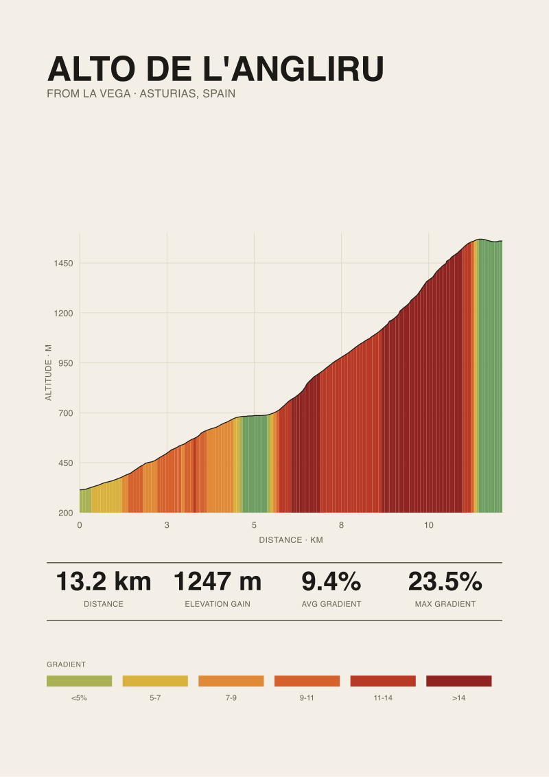
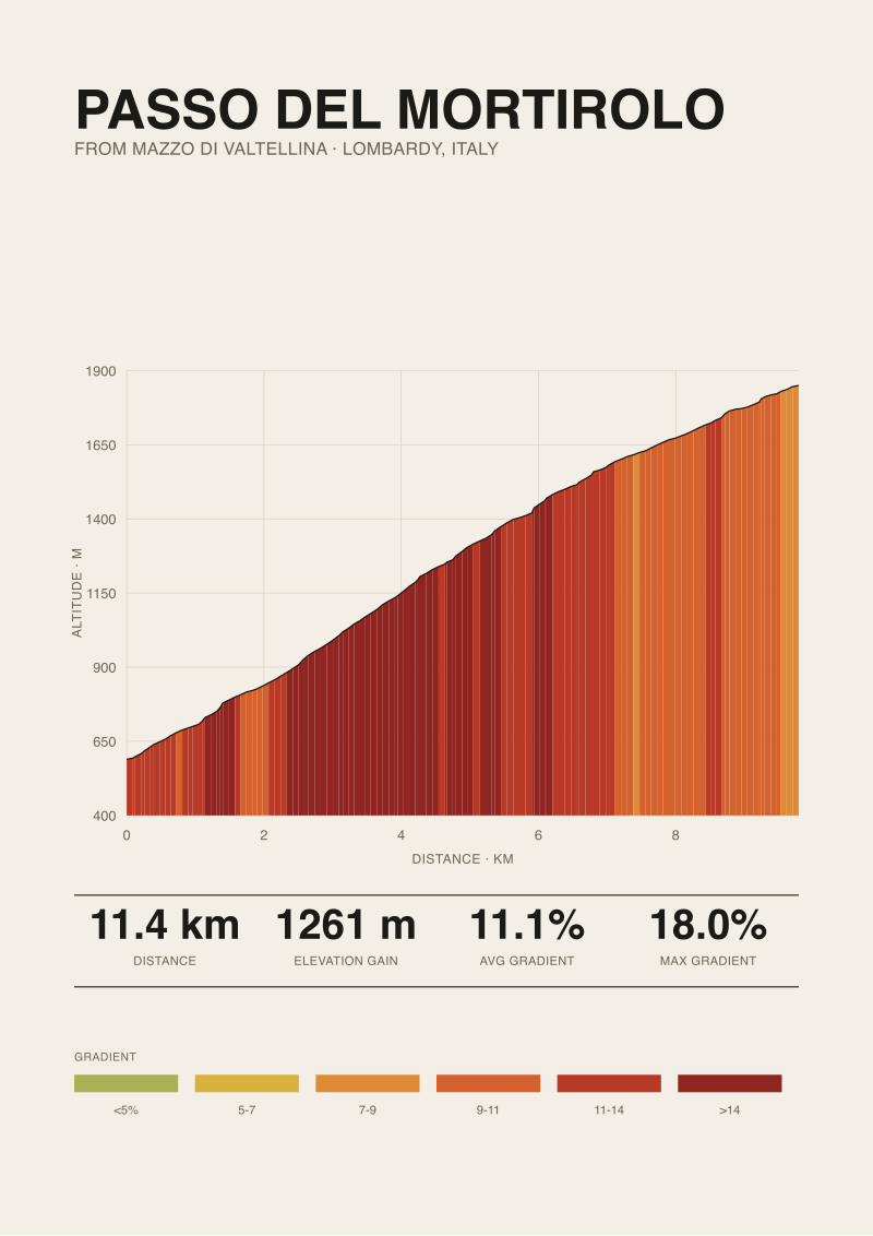
The Zoncolan from Ovaro is famous for the last five kilometres, and our numbers do not tell you what those five kilometres feel like at 22 percent inside a tunnel. They tell you what the whole climb amounts to on paper, which is the only useful frame for comparison against other climbs on other mountains. When we set Zoncolan next to Angliru or Mortirolo in a comparison print, the frame we set them in is exactly this frame: length, gain, start, summit, average, and the published maximum with its source. Five numbers and a citation. It is the smallest set that lets a rider or reader hold two climbs in their head at once without one of them being flattered by rounding.
 Alto de l'Angliru
The print from this article · from €29.95
View the print →
Alto de l'Angliru
The print from this article · from €29.95
View the print →
So What Do You Actually Do
If you read a Zoncolan length figure in an article or a forum thread, the first useful question is not whether the figure is right but where it was measured from. Nine point seven km from Ovaro to the summit, 10.1 km from a road sign a couple of hundred metres below, 10.5 km from the town square — these are all defensible if the author names the anchor. Sources that do not name the anchor are asking to be trusted rather than checked. On a climb this famous, that is worth pushing back on. Ask the anchor.
If you are counting hairpins yourself — from a map, a satellite image, or a memory of riding it — decide first which convention you are using. Every reversal, signed tornanti only, or reversals inside a steep-regime cutoff. Whichever you pick, apply it consistently across every climb you plan to compare. A cross-climb hairpin comparison written in three different conventions is a comparison of the writers' choices, not of the mountains. Our own house convention is to count the signed hairpins where the road authority has posted them and to note the additional unsigned reversals separately when they matter to the ride.
If you are planning a trip around Zoncolan, treat the length and the maximum as complementary readings rather than competing ones. Nine point seven four kilometres at 12.2 percent average tells you what to prepare for over the whole hour. The 22 percent maximum, from Ovaro, tells you where inside that hour the pacing decisions become non-negotiable. Neither number alone describes the climb. Both together, with sources named, is what an honest print of this mountain has to carry — and it is why we keep the sources visible on the profile rather than smoothing them into a single figure that hides how it was made. A print of Zoncolan from our shop prints those five numbers and the citation on the same sheet as the profile, for exactly this reason.
From the collection


New climbs and 10% off your first print.
One email now with your code. No noise after.