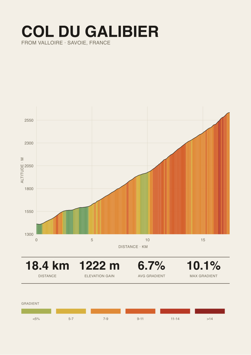
We have read a lot of articles that compare sources for the length of the Col du Galibier from Valloire, and they all collapse into the same shape: a table of three numbers, a shrug, and a sentence about how "it depends on where you start." Our own measurement of the Valloire side, drawn from OpenTopoData SRTM 30m elevation, puts the climb at 18.37 km for 1,222 metres of gain, starting at 1,412 m and topping out at 2,634 m — an average gradient of 6.7 percent, with a published maximum of 10.1 percent cited by climbfinder.com. Three numbers that should settle an argument. They do not, because the argument is not actually about the mountain.
The second paragraph of those articles is almost always worse than the first. It tells the reader that "all three sources are basically right," then quietly moves on. We think that sentence is where the piece dies. If three sources give three different lengths for the same road, exactly one of three things is true: they are measuring from different start points, they are measuring with different instruments, or at least one of them is wrong. Each of those possibilities has a different answer. Blending them into a shrug is not neutrality — it is the editorial version of refusing to pick up the measuring wheel.
What They All Get Wrong
The shared error is treating length as a scalar. A climb's length is not a single number waiting to be discovered; it is a measurement that depends on three choices, and almost no article names those choices out loud. The first choice is the start point. The second is the horizontal path — the actual line you trace through hairpins. The third is the vertical resolution of your elevation model, which determines whether short false-flats and dips get counted as "length" or absorbed into the average. Change any one of those three and the number moves by hundreds of metres. Change all three and you can move it by more than a kilometre.
Most comparison articles do not even state where their "Valloire start" is. The village of Valloire runs along the Valléé de la Valloirette for roughly a kilometre and a half. A climb that starts at the southern edge of town, outside the église, measures differently from one that starts at the roundabout by the tourist office, which measures differently again from one that starts at the Plan Lachat junction further up. All three are defensible. None of them is wrong. But a comparison that puts "Climb A: 17.5 km, Climb B: 18.4 km, Climb C: 19.1 km" without naming the start of each is comparing three different rides and calling them the same climb.
The second error is treating road books and satellite elevation data as if they were trying to answer the same question. They are not. A road book is a navigational document — it is telling a rider or a race convoy how far they will drive along the official race route. Satellite elevation models like SRTM 30m are gridded samples of ground height, interpolated along a path. The road book inherits its horizontal path from the roadbuilder; the SRTM measurement inherits its from whatever GPS trace you overlaid on the grid. If the trace cuts hairpins or snaps to the centreline instead of the apex, you can lose a hundred metres per switchback. On the Valloire side there are enough switchbacks for that to matter.
The third error, and the most common, is reporting the maximum gradient as if it were a direct observation. For the Galibier from Valloire, the figure that appears everywhere — including our own grounding — is 10.1 percent, sourced from climbfinder.com. That is a published value from a road book tradition, not something a satellite measured in a 30-metre cell. SRTM at 30-metre resolution cannot resolve a 50-metre ramp at 10 percent; it will smooth it. When an article prints "max gradient 10.1 percent" next to a "length 18.37 km" that came from SRTM, it is quoting two instruments without saying so.
What Is Almost Always Missing
What is missing from every comparison we have read is the methodological footnote that would make the comparison honest. Specifically: the start coordinate, the elevation data source, the horizontal path source, and the resampling interval. Those four fields together define a measurement. Without them, a length number is a rumour. With them, two measurements that disagree become interpretable — you can see which of the four assumptions moved, and by how much.
The second thing missing is a sense of scale for the disagreement. For the Valloire ascent, the published figures we have encountered cluster between roughly 17.5 and 19 kilometres. That is a spread of about 1.5 kilometres on a climb whose average gradient is 6.7 percent — which translates to roughly 100 metres of elevation gain that may or may not be "in" the climb depending on who is counting. On a mountain that gains 1,222 metres total, 100 metres is 8 percent of the climb. That is not noise. That is a meaningful difference that nobody flags because flagging it would require writing a paragraph about measurement rather than a sentence about scenery.
The third thing missing is the asymmetry between the two directions on the Galibier. The pass has two faces — Valloire to the north, Lautaret to the south — and the Valloire side's length depends on whether you consider the climb to begin in Valloire village (1,412 m, in our data) or at the junction with the D902 at Saint-Michel-de-Maurienne, which is where the Télégraphe starts and where many riders consider the "Galibier day" to actually begin. The articles that compare three sources almost never state which of those two framings their sources used. One is a 18-kilometre climb at 6.7 percent. The other is a 35-kilometre affair that includes the Télégraphe, a descent through Valloire, and the final ascent. Both are called "the Galibier from Valloire" in casual writing. They are not the same climb.
What is also missing is any acknowledgement that the shortest number is not automatically the "cleanest" and the longest is not automatically the "most generous." A shorter length can mean a tighter definition of the start, or it can mean a trace that cut hairpins and lost horizontal distance. A longer length can mean a more faithful trace through the switchbacks, or it can mean a start pushed down the valley to inflate the figure. Direction of the error is not predictable from the magnitude of the number. You have to look at the method.
 Col du Galibier
The print from this article · from €29.95
View the print →
What I Would Say Instead
Our framing is that there is no "real" length of the Col du Galibier from Valloire. There is only a length that is defensible once you have declared your method. The question "which of the three sources is right" is the wrong question. The right question is: "which of the three sources tells you what it did, and does what it did match the ride you are planning or the comparison you are making?"
For the Valloire side, we would say the following. If the start is the southern edge of Valloire village — the point where the gradient first turns up and does not come down again before the summit — and the horizontal path is the centreline of the D902 traced through every hairpin, and the vertical model is SRTM 30m resampled at a sensible interval, the climb is 18.37 kilometres for 1,222 metres of gain, averaging 6.7 percent. We can defend that number because we can name its four assumptions. If one of those assumptions moves — if the start shifts a kilometre north into the village, or the trace is simplified, or the elevation model is replaced with a higher-resolution LIDAR dataset — the number will move, and we would expect it to move in a direction we can predict in advance.
That is a different kind of answer than the shrug. It gives the reader something to do with the disagreement. If they see another source listing 17.5 kilometres, they can look at that source's start point and probably find it in the village rather than at the edge. If they see 19 kilometres, they can look for a start pushed down toward the valley floor. The three numbers are not three guesses at a hidden truth. They are three measurements that each answer a slightly different question, and the differences between them are legible if you ask the right follow-up.
The maximum gradient belongs in a separate paragraph for the same reason. The published 10.1 percent figure from climbfinder.com is a road-book value, not a satellite observation. It describes a specific short ramp on the Valloire side — the ones most riders feel in the final kilometres before the Plan Lachat junction, where the gradient steepens before the long upper slope to the tunnel. We quote that number because it comes from a tradition that was looking at the road, not from a 30-metre grid that cannot see the ramp. Mixing the two sources inside one line — "18.37 km at 6.7 percent, max 10.1 percent" — is only honest if the sentence that follows names them separately. We would name them.
The useful artefact from all of this is not a verdict. It is a template. For any climb where sources disagree, four fields resolve almost all of the disagreement: start coordinate, horizontal path source, elevation model and resolution, resampling interval. Three sources that each publish those four fields can be compared cleanly. Three sources that publish only a length cannot. Our print of the Valloire ascent — the data behind the profile we draw and sell at /shop/ — carries those four fields in its caption, because we think the caption is where the authority of a climb print actually lives. Three numbers, properly footnoted, settle more arguments than any single number ever will.
FAQ
Why does the length of the Col du Galibier from Valloire vary so much between sources?
Three independent choices move the number: where the start is placed, how faithfully the horizontal trace follows the hairpins, and what elevation model is used. For the Valloire side the spread between reputable sources is roughly 17.5 to 19 kilometres — about 1.5 kilometres, or 100 metres of elevation gain on a 1,222-metre climb. None of those sources is wrong in isolation. They are answering slightly different questions and almost never stating which question they answered.
What is the most defensible length figure for the Valloire ascent?
Measured from OpenTopoData SRTM 30m elevation, with the start at the southern edge of Valloire village (1,412 m) and the horizontal path following the D902 centreline through every hairpin to the summit at 2,634 m, the climb is 18.37 kilometres for 1,222 metres of gain at an average gradient of 6.7 percent. Any single-number alternative must declare its own four assumptions to be comparable.
Is the 10.1 percent maximum gradient measured or published?
Published. The 10.1 percent figure is cited by climbfinder.com from a road-book tradition and describes a specific short ramp on the Valloire side. Satellite elevation models at 30-metre resolution cannot reliably resolve ramps that short, so the maximum gradient in this grounding is a road-book value, not a measurement from the same instrument that produced the length and average. The two numbers come from different sources and should be read as such.
Does "Galibier from Valloire" include the Col du Télégraphe?
Not in our measurement. The 18.37-kilometre figure covers only the ascent from Valloire village to the Galibier summit. Many riders and race road books frame the day as starting at Saint-Michel-de-Maurienne, which includes the Télégraphe climb, a descent through Valloire, and then the Galibier itself. That composite ride is roughly 35 kilometres with an intermediate descent and is a different climb for measurement purposes, even if it shares a name in casual conversation.
Why does SRTM 30m resolution matter for this climb?
Horizontal grid spacing of 30 metres means the model samples ground height roughly every 30 metres along the trace. Short features — a 50-metre ramp at 10 percent, a brief dip at a hairpin — get smoothed into the surrounding slope rather than reported as peaks. That is why average gradients from SRTM are reliable and maximum gradients are not. Any claim about the steepest pitch of the Galibier needs a higher-resolution source or a road-book figure, not an SRTM read.
Which four fields should a trustworthy length figure disclose?
Start coordinate, horizontal path source, elevation model and resolution, and resampling interval. Those four values together define a climb measurement. Two sources that disclose all four can be compared cleanly, and any disagreement between them can usually be traced to one specific assumption. Sources that publish only a length and a gradient leave the reader no way to reconcile their number with anyone else's.
Does cutting hairpins in the GPS trace shorten the measured climb?
Yes, and by more than most readers expect. Each tight switchback on the Valloire side contributes a small arc of horizontal distance that disappears if the trace is simplified or snapped to a straight line between entry and exit of the hairpin. Across the full ascent that can account for a hundred metres or more of lost length. A trace that follows the road centreline through every apex will measure longer than one simplified for file-size reasons, even though both describe the same ride.
Is one of the three sources flat-out wrong?
Usually not. In our experience the three numbers in a typical comparison each answer a defensible version of the question, and the "disagreement" dissolves once the start points and traces are named. The error is almost always in the comparison, not in the sources — presenting three measurements as if they were three guesses at the same hidden value, when in fact they are three distinct measurements of slightly different objects. Name the method and the numbers stop fighting.
From the collection
New climbs and 10% off your first print.
One email now with your code. No noise after.