There is a pattern the desk sees every spring: the inbox fills with route plans labelled "first Alps trip" that include Mont Ventoux and the Col du Tourmalet alongside the Passo dello Stelvio and the Passo di Gavia. Ventoux sits in the Vaucluse, 1,892 m of Provençal limestone. Tourmalet is in the Hautes-Pyrénées, 2,114 m of a different mountain range entirely. Of the four climbs first-timers most commonly stack together, only two — Stelvio at 2,748 m and Gavia at 2,610 m — are actually in the Alps. The pattern is not ignorance. It is category drift, and it changes what a first trip should look like.
The Category-Drift Pattern: When Ventoux and Tourmalet Get Filed Under "Alps"
Category drift is what happens when a genre expands to absorb anything that vaguely resembles it. In road cycling, "the Alps" has quietly come to mean "any European high climb with switchbacks, a summit café, and a Tour de France or Giro d'Italia stage in its résumé." The physical range has almost nothing to do with it anymore. The result is that route plans arrive with Mont Ventoux — a limestone dome in Provence, 250 km south-west of the closest Alpine massif — sitting in the same itinerary as the Passo dello Stelvio, which is in the Ortler Alps of South Tyrol and is by any strict definition Alpine.
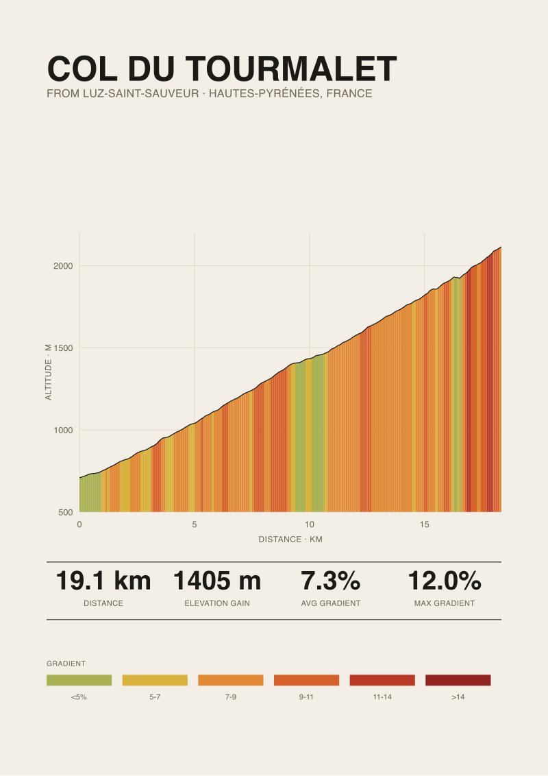
The Col du Tourmalet gets pulled in the same way. Tourmalet climbs 1,405 m over 19.12 km from Luz-Saint-Sauveur, topping out at 2,114 m in the Hautes-Pyrénées. It is a Pyrenean climb in the way that a Cabernet is a Bordeaux — the terroir is not incidental to what the climb is. Pyrenean climbs are typically shorter than the classic Alpine giants, sit at lower absolute altitudes, and have a different weather pattern shaped by the Atlantic rather than by the Alpine convergence. Filing Tourmalet under "Alps" throws away the geography that makes it interesting.
We are not being pedantic for its own sake. The categorical mistake matters because the planning follows the category. A first trip designed as "Alps" — meaning Stelvio at 2,748 m and Gavia at 2,610 m, both above 2,500 m at the summit — is a different logistical animal from a first trip built around Ventoux (1,892 m summit) and Tourmalet (2,114 m). Weather windows differ. Acclimatisation matters or does not. Gear lists diverge. When a plan mixes both categories under one label, one of the two gets under-prepared for. Usually it is the Alpine half, because the Provençal and Pyrenean climbs feel like the "real" targets on paper and the Alpine numbers get treated as more of the same.
The Average-Gradient Trap: Why 7.3% Means Four Different Climbs
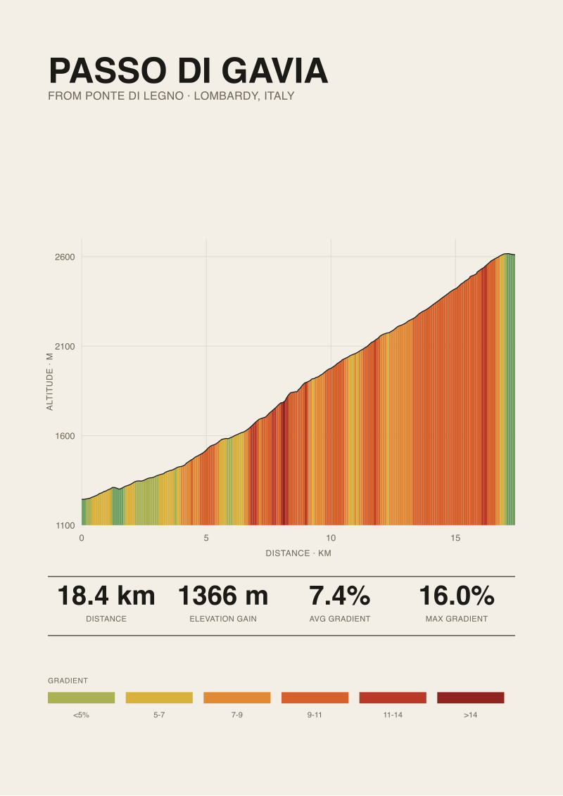
Here is a fact that ought to be more disquieting than it usually is. Measured from Prato allo Stelvio, the Stelvio averages 7.3%. Measured from Bédoin, Ventoux averages 7.3%. Measured from Luz-Saint-Sauveur, Tourmalet averages 7.3%. Gavia from Ponte di Legno averages 7.4%. Four climbs, four averages within a tenth of a point. If average gradient told you what a climb felt like, these four would be the same ride.
They are not the same ride, and the number that betrays the average is the maximum. Climbfinder publishes 14% for Stelvio, 12% for Ventoux, 12% for Tourmalet, and 16% for the Ponte di Legno side of Gavia. A four-point spread in maximum gradient across climbs with identical averages tells you that the shape of the profile is doing all the work the average has hidden. A climb that averages 7.3% by staying at 7.3% for twenty kilometres is a metronome. A climb that averages 7.3% by holding 5% for long stretches and then punching 14 or 16% out of a ramp is a series of ambushes.
The average trap gets worse when a first-timer uses it to seed pacing. On the Stelvio you can more or less settle in — the profile from Prato has 48 numbered hairpins and the gradient behaves. On Gavia, the same average conceals ramps in the lower half where the pitch bites hardest against tired legs at a point in the ride where the altitude has not yet started to hurt. On Ventoux, the average is a lie of composition: the forest section from Saint-Estève is a wall for six kilometres, then the gradient eases marginally through Chalet Reynard, then the exposed summit stretch does something the number cannot describe, which is take away shelter, shade, and any sense of scale.
Four climbs with the same average gradient are not the same climb; they are four different bets on where the pain arrives.
 Passo dello Stelvio
The print from this article · from €29.95
View the print →
Passo dello Stelvio
The print from this article · from €29.95
View the print →
The Altitude Blind Spot: First-Trip Plans Undercount the Metres Above 2,000
Riders who have never climbed above 2,000 m at speed tend to plan as if the top of a climb were just the last kilometre of the middle of a climb. It is not. The physiology changes, the weather changes, and the margins for error compress in ways the profile chart does not draw. This is where the four-climb comparison stops being polite.
Ventoux tops out at 1,892 m. That is below the 2,000 m line. A rider who has done Ventoux and files it as "high-altitude experience" has, strictly, no high-altitude experience. Tourmalet at 2,114 m puts 114 m above 2,000 into the legs — most of it in the final push toward the summit, where the road opens up and the wind takes over. Gavia at 2,610 m puts 610 m above the line. Stelvio at 2,748 m puts 748 m above. The gap between what a Ventoux climb teaches you and what a Stelvio summit demands is not a rounding error; it is more than 850 m of vertical difference at the top, most of it in the range where thin air, sudden weather, and cold hands with poor braking become the actual problem.
The category-drift pattern hides this. When Ventoux and Tourmalet get shelved next to Stelvio and Gavia under the label "Alps", the altitude blind spot is baked in. A first-timer arrives with Ventoux-shaped experience and Stelvio-shaped ambitions. The Stelvio summit is often ten to fifteen degrees Celsius colder than the base at Prato allo Stelvio (908 m), and the descent, particularly on the switchbacks north of the summit, is one of the least forgiving in Europe for cold, cramped hands. Gavia's 2,610 m summit sits above snowfields well into June in normal years, and the road on the Ponte di Legno side spends most of its length above 1,500 m — the climb starts at 1,244 m, so the entire 1,366 m of gain happens in air that is already thinner than any point on Ventoux.
The Length-Anchoring Error: Chasing Kilometres, Ignoring Where the Climb Starts
The last pattern is the one that quietly makes the other three worse. First-trip plans get built around length. Stelvio is 25.04 km from Prato and gets sorted as "the long one". Ventoux is 21.51 km from Bédoin — "second longest". Tourmalet is 19.12 km from Luz-Saint-Sauveur. Gavia is 18.42 km from Ponte di Legno. Kilometre length becomes the sorting key, and the plan gets sequenced around it: shorter climbs earlier in the trip, the long one at the end.
The problem is that length in kilometres is measured from where the climb starts, and the four climbs start at wildly different altitudes. Stelvio from Prato begins at 908 m. Ventoux from Bédoin begins at 317 m. Tourmalet from Luz-Saint-Sauveur begins at 709 m. Gavia from Ponte di Legno begins at 1,244 m. The elevation gain corrects for this — 1,840 m for Stelvio, 1,575 for Ventoux, 1,405 for Tourmalet, 1,366 for Gavia — but only if the reader reaches for gain rather than length. Most plans do not.
Chasing kilometres puts Gavia in the "short and easy" bucket. It is neither. Gavia gains 1,366 m in 18.42 km at a 7.4% average and does that gaining almost entirely above 1,500 m, punctuated with published ramps to 16% on the Ponte di Legno side. Its length is the least honest number in the set. Meanwhile Ventoux, which has more elevation gain (1,575 m) than Gavia and starts in the warmth of Provence at 317 m, tops out lower than Gavia begins. Reading these climbs on kilometre length alone gets the whole trip's difficulty curve wrong, because it hides where the vertical work sits on the altitude line.
 Mont Ventoux
The print from this article · from €29.95
View the print →
Mont Ventoux
The print from this article · from €29.95
View the print →
So What Do You Actually Do
Plan the trip around gain and summit altitude, not around length in kilometres or around the word "Alps". If a first trip is meant to be genuinely Alpine, that means Stelvio from Prato allo Stelvio (908 m start, 2,748 m summit, 1,840 m of gain over 25.04 km) and Gavia from Ponte di Legno (1,244 m start, 2,610 m summit, 1,366 m of gain over 18.42 km). Both climb into altitude ranges that Ventoux and Tourmalet do not reach. Both live at the top of the risk column for weather and cold on the descent. Neither is optional gear-wise: full-finger gloves, a rain shell that packs small, and enough calories to eat on both climbs and both descents.
If a first trip is really a European-climbing trip and the label "Alps" is being used loosely, then be honest about it. Build the trip around one Alpine target — Stelvio is the reasonable choice for a first-timer because the Prato ascent behaves and the hairpins are numbered like a countdown — and use Ventoux or Tourmalet as the mid-range test the week before. Do not stack Stelvio and Gavia in the same 48-hour window on a first trip. The published maximum of 16% at Gavia's lower ramps arrives in air that is already thinner than the base of any of the other three, and doing that with Stelvio in the legs is not the trip a first-timer wants written up.
Watch three signals on any route plan before it is booked. First, look at where each climb starts, not just how long it is: a start elevation above 1,000 m is doing quiet work the profile chart does not draw. Second, count metres above 2,000 m at the summit — anything past 500 m into that band changes the cold and the weather calculus, and Ventoux at 1,892 m does not qualify. Third, when the published maximum gradient and the average diverge by more than seven percentage points — as they do at Gavia (7.4% average, 16% published max) and Stelvio (7.3% and 14%) — the profile is hiding ramps, and the pacing plan needs to be rewritten around them rather than around the average.
We render these four climbs as prints because we spent the time measuring them first, and the measurements are the reason we can tell first-timers that only two of the four are actually in the Alps. If the plan wants to hang one on the wall as the memory of a first trip, choose the one whose numbers you understood before you rode it. The studio's shop has all four.
From the collection

New climbs and 10% off your first print.
One email now with your code. No noise after.