25.04 km, 1,840 metres of gain, an average of 7.3% — that is Passo dello Stelvio from Prato allo Stelvio, measured off 30-metre satellite elevation, and it is the shape of climb most riders imagine when they book a European cycling week. Mallorca does not offer that climb. The island's road book contains nothing that stacks 1,800 metres in a single ascent, and our own measured library currently holds Stelvio, Ventoux, Tourmalet and Gavia — not Sa Calobra, not Puig Major, not Coll de sa Batalla. This guide routes riders by asking three questions, in order, and it names what our data cannot yet tell them.
Question 1: Is This Your First European Climbing Trip, or Your Fifth?
This is the fork that decides whether Mallorca is the correct island for the week you are about to book, or a mismatch dressed up as a rite of passage. The question is not about fitness. It is about calibration — whether you already have a personal benchmark against which a European road climb reads as a specific number rather than a general feeling.
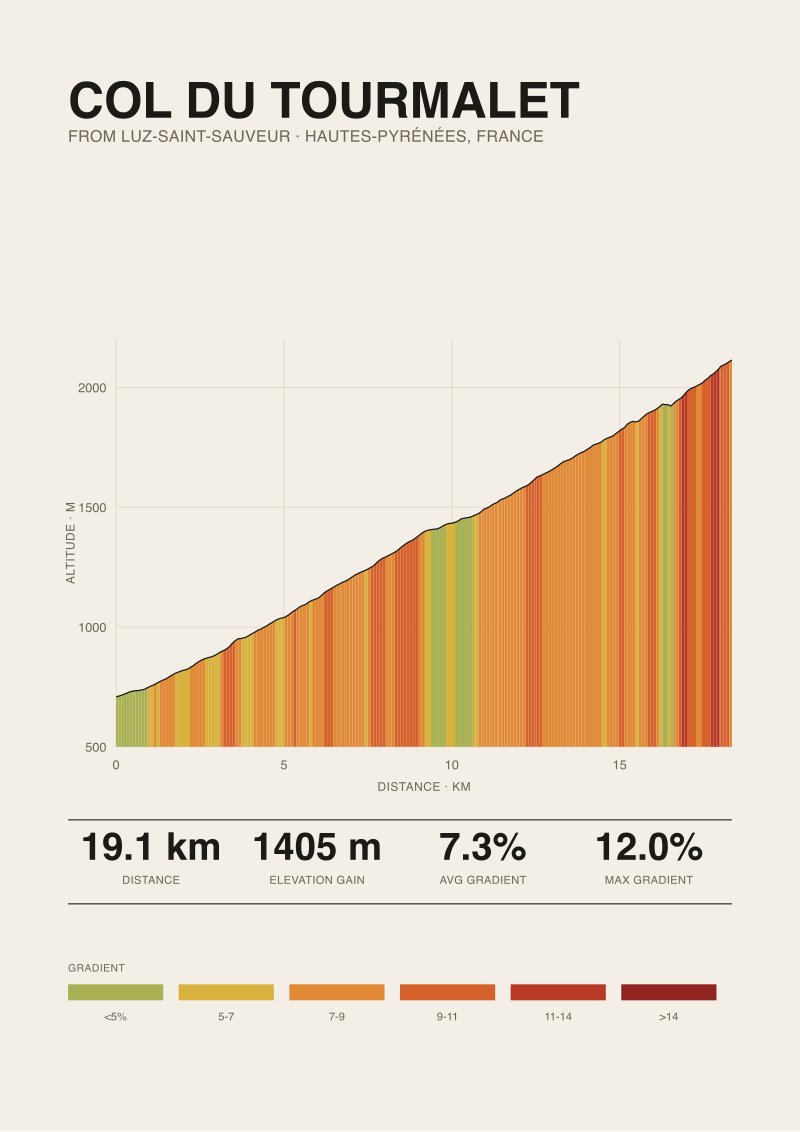
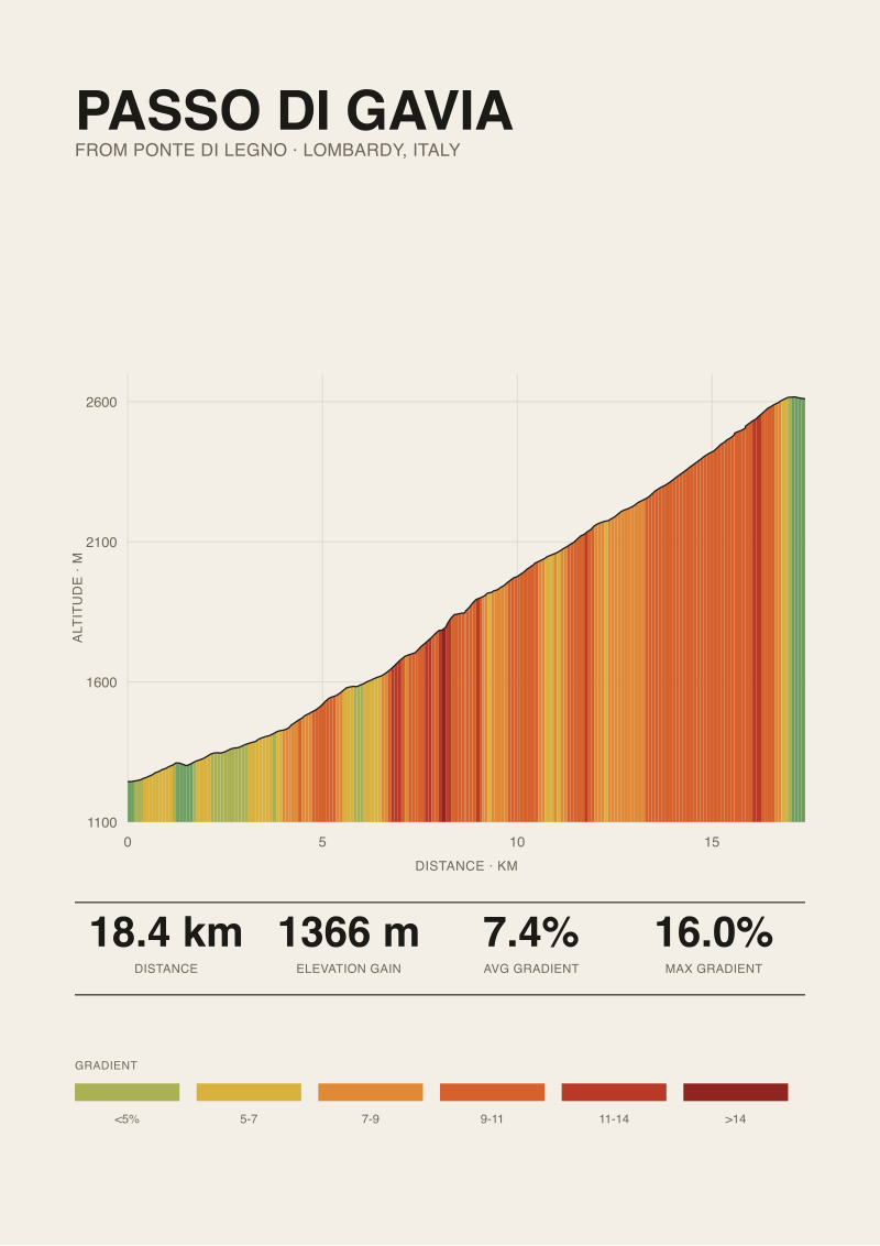
The measured library we hold is unambiguous about what the Alps and Pyrenees ask of a rider. Stelvio from Prato allo Stelvio: 25.04 km, 1,840 metres of gain, summit at 2,748 m. Ventoux from Bédoin: 21.51 km, 1,575 metres, summit at 1,892 m. Tourmalet from Luz-Saint-Sauveur: 19.12 km, 1,405 metres, summit at 2,114 m. Gavia from Ponte di Legno: 18.42 km, 1,366 metres, summit at 2,610 m. Four climbs; four sustained hours near threshold; four summit altitudes where the air itself begins to change the equation.
If Yes — this is your first European climbing trip
Mallorca is the correct answer, and the reason is scale. The island's marquee climbs — the ones every road book names — sit in a length band that lets a rider learn how a sustained European gradient actually behaves without simultaneously learning altitude, weather exposure and psychological length. Coll de sa Batalla, Puig Major from the Sóller side, the Coll d'Honor: these are climbs a rider can repeat inside a single week and refine, rather than survive once and never revisit. We do not yet have our own measured profiles for those roads and we will not quote lengths and gradients we have not measured. What we will say is that the widely published figures place all of them well inside the length of Ventoux and below the summit altitude of Tourmalet. That is the point. A first trip should teach the shape of the climb, not the shape of a bad day.
If No — you already have Alpine or Pyrenean climbs in the legs
Then Mallorca is a different tool, and the honest framing is that it is a volume island, not a climb island. It rewards riders who want 1,500 to 2,500 metres of daily gain distributed across three or four ascents rather than concentrated in one. If your reference climb is Stelvio, no single Mallorcan road will replicate its 1,840-metre stack. If what you actually want in November is base miles with real gradient breaks — 20-minute efforts rather than 90-minute ones — the island does that better than almost anywhere in Europe at that latitude. Book it for what it is.
Question 2: Does the Ride Turn on Length, or on Gradient?
The two variables are not interchangeable and the confusion between them is the single most common reason riders arrive at a European climb miscalibrated. Length is duration under load. Gradient is the intensity of that load at any given moment. A 7.3% average across 25 km — the Stelvio number — is not four times a 7.3% average across 6 km, even though the arithmetic suggests it. Fatigue is not linear, and neither is the physiological cost of holding a given power for an hour versus fifteen minutes.
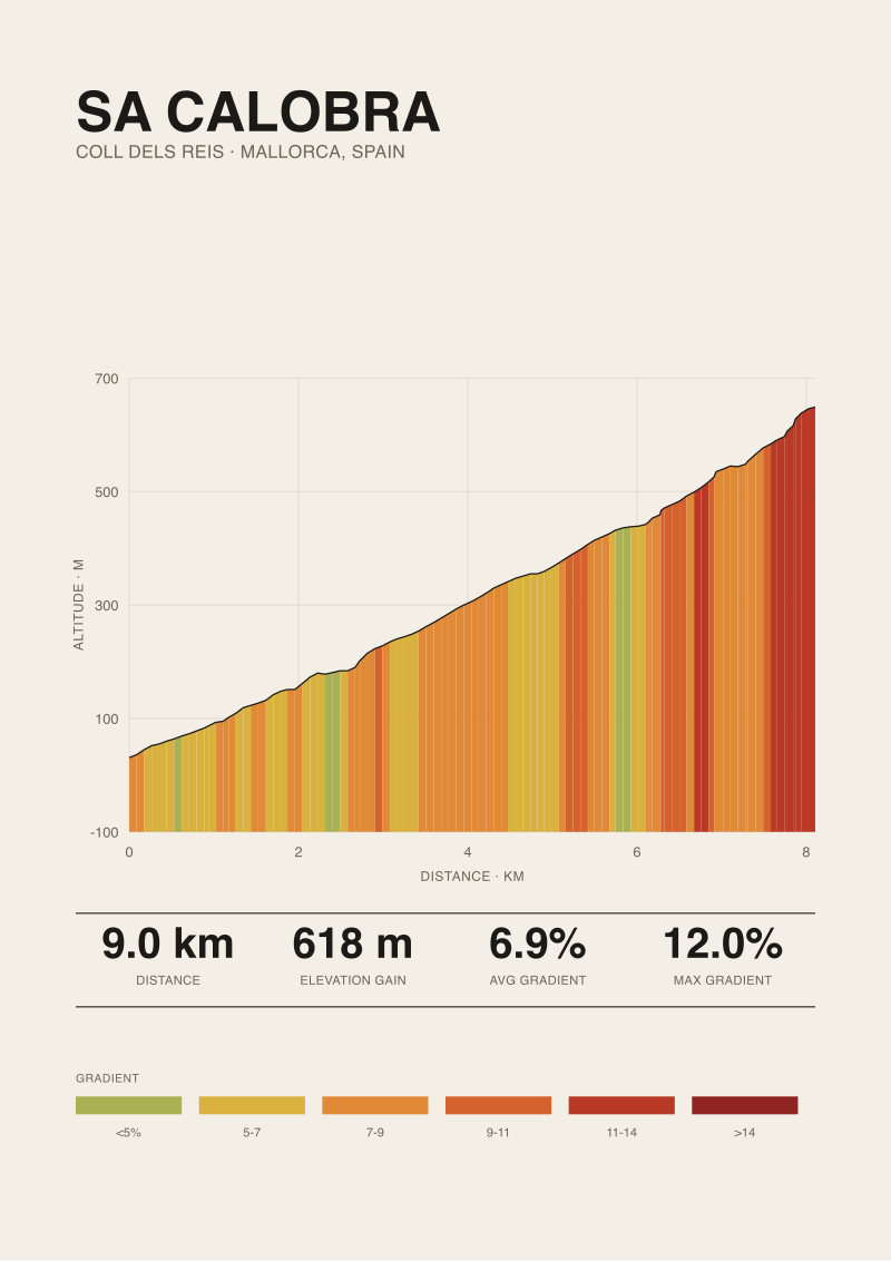
Mallorca's road book, judging from the published figures for its principal climbs, sits closer to the gradient side of that split than to the length side. The averages published for climbs like Sa Calobra and Puig Major from the northern approaches are in the same rough band as our measured Alpine climbs — mid-to-high single digits — but the total lengths are shorter. That produces a different ride. A rider can push closer to threshold for the whole climb without the altitude and duration penalty that Alpine ascents impose in the final third.
If the ride turns on length
Mallorca will feel short. This is not a criticism of the island; it is a description of the geography. If your training plan calls for a 90-minute continuous climbing effort, you will need to stitch ascents together with valley road between them, and the ride ceases to be a climb and becomes a route. That works. Coll de sa Batalla into Puig Major into Sóller is a standard stitch that many riders use for exactly this reason. But the effort profile is interval-shaped, not sustained-shaped, and a rider preparing for Ventoux or Tourmalet should know that distinction before they book.
If the ride turns on gradient
Mallorca is well matched, with one caveat we will name plainly. Our measured library does not yet contain any Mallorcan climb, so we cannot tell you where the steepest ramps sit within any given ascent, only that published road-book figures suggest maxima in the low double digits — comparable to Ventoux's 12% published maximum, well below Gavia's 16% published maximum from Ponte di Legno. If your objective is to spend real time above 8% on repeatable roads with predictable surface, the island delivers. If your objective is to test yourself against isolated 15%+ ramps, the Dolomites or the Asturias are the correct destination and Mallorca is not.
 Passo dello Stelvio
The print from this article · from €29.95
View the print →
Passo dello Stelvio
The print from this article · from €29.95
View the print →
Question 3: Are You Riding in April, or in July?
Season is the third fork because it changes which climbs are available, how long a rider can spend on them, and which risks dominate the day. This is the question where Mallorca's advantage over the high Alps and Pyrenees is at its clearest, and it is worth stating in specific terms rather than in the vague language of "good weather".
The measured climbs in our library are altitude climbs. Stelvio summits at 2,748 m; Gavia at 2,610 m; Tourmalet at 2,114 m; Ventoux at 1,892 m. Passes at those altitudes have narrow riding windows. Stelvio is typically closed to traffic well into late spring; Gavia the same; Tourmalet's higher slopes carry snow that can linger. Ventoux is lower and rideable earlier, but the summit's exposure to the Mistral is not a weather footnote — it is a route-planning variable. Mallorca's climbs sit at altitudes where none of that applies. The season is longer and the failure modes are different.
If April
Mallorca is the correct European road-cycling destination and there is not a close second. The high passes we have measured are either closed or unreliable; the Pyrenean and Alpine climbs that are open have unpredictable surface conditions above 1,500 m. The Mallorcan climbing season is already fully open, temperatures on the climbs are moderate, and the failure mode a rider needs to plan for is wind on the exposed sections and rain rather than snow or ice. Book Mallorca in April, book the Alps in July.
If July
The calculus inverts. Every measured climb in our library is at its best in July; the passes are open, the surface is predictable, and the descents are safe at speed. Mallorca in July is rideable but the heat window shortens the practical riding day to early morning and late afternoon, and the climbs — being lower and less shaded than the Alpine equivalents — offer no altitude relief from the temperature. This is not an argument against Mallorca in summer; the island still works. It is an argument that a rider who has the July calendar free and a choice between islands and mountains should choose mountains, and use Mallorca for the shoulder seasons its geography was built for.
If You Answered Everything: The Routing Table
Eight answer combinations, one recommendation each. The recommendation cell is the one thing we would say to a rider who read the three questions above and answered them honestly.
| Q1: First trip? | Q2: Length or gradient? | Q3: April or July? | Recommendation |
|---|---|---|---|
| Yes | Length | April | Book Mallorca; stitch three climbs into a single 90-minute continuous effort with valley road between them. |
| Yes | Length | July | Book the Alps or Pyrenees; a first sustained European climb is best learned on one, not assembled from three. |
| Yes | Gradient | April | Book Mallorca; this is the closest match between your objective, your calibration and the calendar. |
| Yes | Gradient | July | Book Mallorca if heat tolerance is high; otherwise a shoulder-season Alps trip beats a hot Mallorca week. |
| No | Length | April | Book Mallorca for base volume and treat it as preparation, not the objective; the length climb comes later. |
| No | Length | July | Book Stelvio, Tourmalet or the Ventoux–Bédoin ascent; the length you want is measured and available. |
| No | Gradient | April | Book Mallorca; ride the northern climbs at intensity and save the isolated steep ramps for a Dolomites week. |
| No | Gradient | July | Book Gavia or the Asturias; published maxima above 15% require terrain Mallorca does not offer. |
The table is deliberately narrow. Three questions cannot resolve every rider's calendar, budget, and travel logistics, and we make no claim that they do. What they resolve is the question that most rider forums answer badly, which is whether Mallorca is the correct European island for a specific rider in a specific week. Everything downstream of that — which hotel, which rental, which coffee stop at the top of Coll de sa Batalla — is beyond the scope of a data guide.
This piece does not cover the specific gradient profiles of Sa Calobra, Puig Major or Coll de sa Batalla, because our measured library does not yet include Mallorcan roads and we will not quote figures we did not derive. It does not cover ferry logistics from Barcelona or Valencia, which are a travel-desk question and not a climb-intelligence one. And it does not cover indoor training substitutes for any of the four climbs discussed, because the whole argument of this desk is that a climb has a shape and that riding it is not the same as approximating it. When our Mallorca profiles are measured, we will publish them, and the prints of the climbs we have already drawn will be joined by the island's own.
 Mont Ventoux
The print from this article · from €29.95
View the print →
Mont Ventoux
The print from this article · from €29.95
View the print →
FAQ
How does Mallorca compare to Stelvio for a rider training for a long climb?
It does not, and that is the honest answer. Stelvio from Prato allo Stelvio is 25.04 km with 1,840 metres of gain across a 7.3% average, summitting at 2,748 m. No single Mallorcan road stacks that continuous vertical, and the island's summit altitudes are far lower. A rider training for Stelvio can use Mallorca for base volume and for tolerating sustained mid-single-digit gradients, but the specific challenge of a 90-plus-minute continuous ascent at altitude has to be replicated somewhere with the actual terrain — the Alps, the Pyrenees, or the higher Dolomites.
Why does the guide not quote lengths and gradients for Mallorcan climbs?
Our measured library currently holds Stelvio, Ventoux from Bédoin, Tourmalet from Luz-Saint-Sauveur, and Gavia from Ponte di Legno, all derived from OpenTopoData SRTM 30 m elevation. We have not yet measured Mallorca's roads to the same standard. Rather than repeat road-book figures whose measurement basis we cannot vouch for, we route the reader by relative shape — length versus gradient, altitude versus sea level, sustained versus interval — and reserve specific numbers for the climbs where we own the measurement.
Is the Ventoux maximum gradient really 12%?
Climbfinder publishes 12% as the maximum for the Bédoin ascent of Ventoux, and that is the figure we cite for the published road-book maximum. Our own measurement of the climb, drawn from 30-metre satellite elevation, gives a length of 21.51 km and 1,575 metres of gain — an average of 7.3%. Satellite-derived maximum gradient depends heavily on the sampling interval and does not always agree with road-book figures, which is why we separate the two sources in our data rather than collapsing them into a single number.
When is the earliest a rider can plan a European climbing week?
April, if the destination is Mallorca. The Alpine passes in our measured library summit between 1,892 m and 2,748 m, and at those altitudes early-season conditions are not reliable — Stelvio and Gavia in particular are often closed or partially closed well past the calendar's turn to spring. Ventoux is lower and opens earlier but is exposed to the Mistral. Mallorca's climbs are at altitudes where none of these constraints apply, which is why the island effectively opens the European road-cycling season each year.
What does "average gradient" actually mean on a measured profile?
It is the total elevation gain divided by the horizontal distance, expressed as a percentage. Stelvio's 7.3% average across 25.04 km is 1,840 metres of gain over that distance. The number is honest but incomplete: it does not tell a rider where the steepest ramps sit, how long the flat or descending sections are that mathematically pull the average down, or how the gradient behaves in the final kilometres where fatigue costs the most. A profile drawn from the data shows those things; an average alone hides them.
Does the guide recommend a specific route order for a Mallorca week?
No, and the omission is deliberate. Route ordering depends on the base hotel, the group's daily volume tolerance, the wind forecast for a given week, and whether the rider is chasing kilometres or specific climbs. The three questions above resolve whether Mallorca is the correct destination and what the ride there should optimise for. Turning that into a day-by-day plan is the work of a local guide or a route-planning tool with live wind and traffic data, not a climb-intelligence desk.
How do satellite elevation and published road-book figures differ?
Satellite elevation — the OpenTopoData SRTM 30 m source we use — samples the terrain on a 30-metre grid and computes gain from that. Road-book figures are typically derived from surveyed profiles or from cyclometer averages compiled over many ascents. The two agree closely on total length and total gain for most well-known climbs. They diverge more on maximum gradient, because a 30-metre satellite grid smooths short, steep ramps that a wheel-based measurement captures. When the divergence matters for the argument, we name both figures and their sources.
Will Climb Prints publish measured profiles of Mallorca's climbs?
Yes, when we have measured them to the same standard as the four climbs in the current library. Until then, we would rather route riders by relative shape and structural comparison than publish figures we did not derive. The prints in the shop today are of the climbs whose profiles we own end-to-end; when the Mallorca profiles are measured, they will join the same shelf under the same rule.
From the collection
New climbs and 10% off your first print.
One email now with your code. No noise after.